My SR22, wich I bought a few months ago, is equipped with Avidyne and two Garmin 430Ws. These have the silver backed NavData cards.
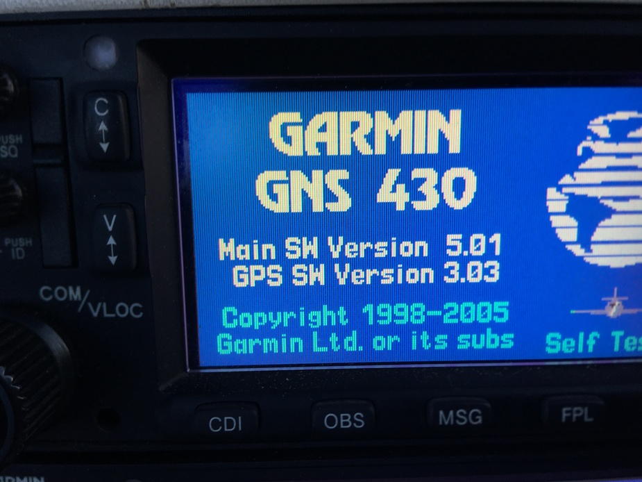
It seems that the previous owner did not think it worthwhile to update the units’ software. I think it’s very old. When the units boot up they show the main software as v.3.30 and the GPS as v3.2
The aircraft is currently in the hangar for its annual, so I’m wondering whether to update the software (which @NCYankee posted recently is now v5.2).
My specific queries to the avionics gurus are:
1. What, if any, enhancements will I get on the 430Ws by making the upgrade? and
2. When updated will the units still be able to read data from the silver NavData cards (or will I need to get the more modern orange data cards?)
Any info on this would be much appreciated.
I got the upgrade from the same version you have to version 5.0 last week, and the silver cards that came with the 2 used W units work fine. I do not know about V 5.2, i got 5.0
Main improvement besides some other are LPV and LNAV/VNAV approaches, very important IMHO.
My avionics company did the SW upgrade for free.
I just learned that you only need V5.2 if you want to connect a Flightstream 210
I recommend upgrading to version 5.2. Version 3.3 has many bugs in it and the later versions have new features, for example 100 waypoints in the flightplan up from 31 waypoints. This is helpful when you are entering long routes on airways. LP approaches also have advisory vertical guidance added. It costs the same to upgrade, why would you want to pay for an upgrade to a lower level. There are also fixes in the GPS function that I would recommend at the same time. Here is a list of improvements and fixes from version 3.3:
Version 4.01
• Added HTAWS functionality (requires an enablement card)
• Added Helicopter/Fixed Wing installer configuration options
• Added support for 2 GB Terrain Cards
• Corrected an issue where GPWS alerts (Premature Descent, Excessive Descent Rate, and Negative Climb Rate) on external annunciators were inhibited when TAWS was inhibited
• Corrected an issue where certain procedures omitted initial fix-to-FC legs or initial fix-to-FD legs from a loaded flight plan if they immediately followed a hold-to-fix leg
• Corrected an issue where TO/FROM toggle for waypoint sequencing did not occur when auto sequencing to a DF leg
• Corrected an issue where speed or course changes caused excessive map updates resulting in the Navigation Map not updating
• Approach VDI now correctly becomes invalid when the system indicates TERM
• Corrected an issue with missed approach turn direction when MAP and MAHP were same waypoint
• Modified ARINC Label 147 to output actual magnetic variation, even when in True mode
• Corrected an issue with FC or FD legs where the 430W / 530W output the “From” waypoint ident to the G500/G600 instead of the Active waypoint
• Added support for WAAS LPV approaches with 3-digit approach identifiers
Version 5.03
The GNS 400W / 500W Series Main Software version 5.00 adds a number of new capabilities and features. It contains the following changes:
• Added support for GTN crossfill (i.e. the sharing of user waypoints and transferring the active flight plan from a GTN to a GNS).
• Added support for Garmin’s GDL 88 ADS-B transceiver.
• Added support for AC 20-165 compliant ADS-B Out operation of the GTX 330 ES transponder when the GNS unit is used as a position source.
• Added support for Canadian METARs and TAFs (when available in the XM Weather package provided by the GDL 69) in the XM Weather package provided by the GDL 69.
• Increased the software design assurance level for the Terrain Page maps to level C. Main software version 5.00 meets TSO-C194 for HTAWS.
• The Procedures page now hides LNAV/VNAV-only approaches that are not authorized for SBAS.
• Corrected the issue where the text for XM METARs and TAFs was not being displayed for some airports with three-character identifiers. This issue only occurred in situations where a ‘K’ identifier and a non-‘K’ identifier are associated with different airports, such as K1A5 and 1A5.
• Corrected inconsistencies in the reference heading shown on the StormScope map page when ground speed drops below 2 mph.
• The waypoint field on the RAIM Prediction page has been changed to default to the destination airport.
• Added a new Configuration page to allow TAWS Airport Criteria to be specified. This option allows an installer to remove from consideration in the TAWS algorithms airports that can’t be used by the aircraft.
• Increased the maximum number of waypoints in a Flight Plan Route from 31 to 100.
• Added additional checks to the GNS-to-GNS crossfill interface to assure data is provided by a valid source. This change may affect the operation of non-Garmin equipment using this interface.
• Added support for the ADS-B compliant position outputs for the GDL 88 and the GTX 33ES meeting AC20-165.
Version 5.10
GNS 400W/500W Series Main Software version 5.10 includes the following changes:
• Added support for advisory vertical guidance for LP approaches (LP+V).
• Added support for displaying ADS-B traffic on the Navigation Map page when no heading source is installed or valid.
• Increased the maximum range on the Traffic page to 24 NM to support the GTS 800.
• Resolved an issue with the lateral CDI scaling as described in Service Advisory 1344, “LPV and LNAV/VNAV Approach Full Scale Deflection.”
• Resolved an issue with approaches with a glide slope of zero as described in Service Advisory 1372 “Unavailable RNAV (GPS) approaches due to lack of VDA.”
• Resolved an issue where the CDI could indicate cross-track error on the opposite side of the course when a turn was active and the cross-track was very large. This corrects the issue described in Service Advisory 1352, “Incorrect Course During Turn Transition.”
• Resolved an issue where under some circumstances locked waypoints within stored flight plans did not remain locked as intended. This corrects the issue described in Service Advisory 1363 “User-modified terminal procedure stored in Flight Plan may cause error condition.”
• Resolved an issue where changing one map setting on the Map Setup page could change other map settings.
• For units connected to GDL 88 units:
o Suppressed the “Traffic device has failed” alert message during the time when the GDL 88 reports that its GPS is initializing.
o Modified the text of the “Pressure altitude input fault and TAS/TCAS input fault” messages to describe the specific problem, rather than “GDL 88 service required.”
o Suppressed the “ADS-B transmit fail” message when the GDL 88 is not configured to transmit ADS-B data.
o Removed the GDL88 traffic test pattern from the Navigation Map page (leaving it on the Traffic page).
• Resolved an issue where traffic targets could be selected when panning across the NAV map even though the traffic overlay was not being displayed on the NAV map
Version 5.20
GNS 400W/500W Series main software version 5.20 includes the following changes:
• Added support for Garmin Flight Stream 210, providing data including flight plan (input/output) and GPS position to mobile devices over Bluetooth.
• Added support for the Vivisun tri-state HTAWS external annunciator to differentiate between the “HTAWS N/A” and “Pilot Inhibit” annunciations.
• Adjusted the width of the HTAWS Reduced Protection mode search volume to reduce nuisance alerts.
• Changed the behavior of the GDL 88 Traffic page on helicopter configurations so that the display becomes unavailable—ADS traffic targets are not displayed—when heading is invalid and ground speed is below 15 knots
• Resolved an issue affecting the Fuel On Board setting for configurations where fuel flow is provided by an external device but Fuel On Board is not.
NCY: any idea why they upgraded mine to 5.0 only?
Later ones not EASA approved?
Much has been written on the topic of EASA not approving these later versions but since I don’t have a GNS or GTN I have not followed it in detail.
That could be! Will ask tomorrow!
@Flyer59 – thanks for the confirmation that the silver data cards continue to work after the upgrade
@NCYankee – thanks for the list of enhancements from the upgrade. Seemed very worthwhile, so I had it done today (about 3 hours work the avionics shop told me). Looking forward to trying it out but have to wait until prop back from overhaul at Hartzell.
I asked my avionics company today:
They did install version 5.20, but the GPS version is 5.0
3 hours is a joke though. I paid € 67 for the upgrade from FW 3.x and that was 1 hour!
Would a SW update make sense here? Which features would be added, or none? It is a non W GNS430. Thanks!