
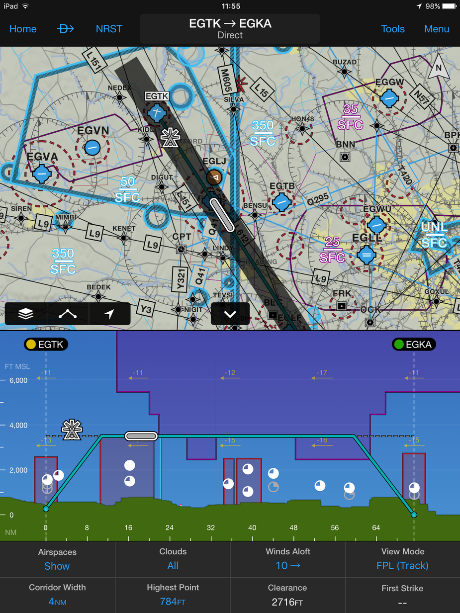
Another image of their new flight profile screen.
Thanks all 
So, let me get this right…
Garmin put a lot of effort into creating “worldwide” airport charts?
Lockheed Martin are doing Eurocontrol route generation and FP filing? FP filing alone is close to worthless in Europe. Worthless for VFR (due to the mindboggling addressing procedures) and worthless for IFR (due to 10 free per month from EuroFPL, AFPEX, Olivia, DFS, etc, etc).
The AIP charts are mostly unusable on a tablet unless you are young or use reading glasses
So even if looking only at enroute VFR charts: once you buy them all (and then you stil have covered only half of Europe), you spend north of 300 pounds / 400 Euros a year. A joke..
That’s even more than JeppFD-VFR, which by now covers probably more than Garmin, and has IMHO the best maps.
But, for many people, “convergence” is worth paying for. A % of IFR pilots (not many admittedly) chuck a few k a year at Jepp data for their panel mounted boxes. And maybe if they can do the same on a tablet…? JeppFD-VFR also gives you georeferenced airport charts, because it includes the Europe-VFR portion of Jeppview.
I think Safetaxi is much better than Jepp
Do you mean in chart readability, or some other aspect of the product? Jepp airport charts seem pretty good – this is LGAV
I am actually looking at getting some sort of airport chart moving map sorted out, but there is nothing cheap… is there?
I mean readability particularly when moving around big airports with complicated taxi procedures. You can really zoom in see hold by hold. Just IMHO of course.
They must think there is a lot of money in that – probably they are aiming at the bizjet scene i.e. upmarket versions of G1000. Avoiding runway excursions / generally not getting lost at big airports has a lot of value.
Against that, Garmin reportedly get paid by Jepp for displaying Jepp data on their products… but there has (rumour) been a big bust-up over that lately.
And they realise they will never displace Jepp for approach plates – in the only market where people actually pay for the stuff  Those who use Jepps but get them from friendly airline pilots etc would have never paid the price anyway. Most light GA would never pay the price.
And there is no real market for enroute IFR (airway charts) because almost nobody flies with them, and the barrier to entry is low due to the raw data being free.
I bought the app as soon as it was out with all its relevant subscriptions, but can’t fall in love yet and keep on using SkyDemon instead. Maybe some day …
Can you be more specific, Aeroplus?
Just to be sure, AIP are geo-referenced, all over Europe? That’s a rather major safety feature, which Skydemon doesn’t yet have ex-UK (VFR approach charts only).
Jason,
I didn’t quite get what you do with ADSB-in filing, can you please explain?
Thanks
But all the airport, airspace and nav data are included in the base subscription. You just need to pay extra if you need actual charts vs their maps which are fine or things like VFR approach plates in Germany.
I also didn’t like it at first but it works well now and will become a good integrated VFR and IFR tool if it keeps going this way.
Denopa, I get ADS-B in via a GDL39-3D but the new Garmin transponders that were just announced provide in and out and integrate with the App. Filing is different that is a new feature they are adding eventually.
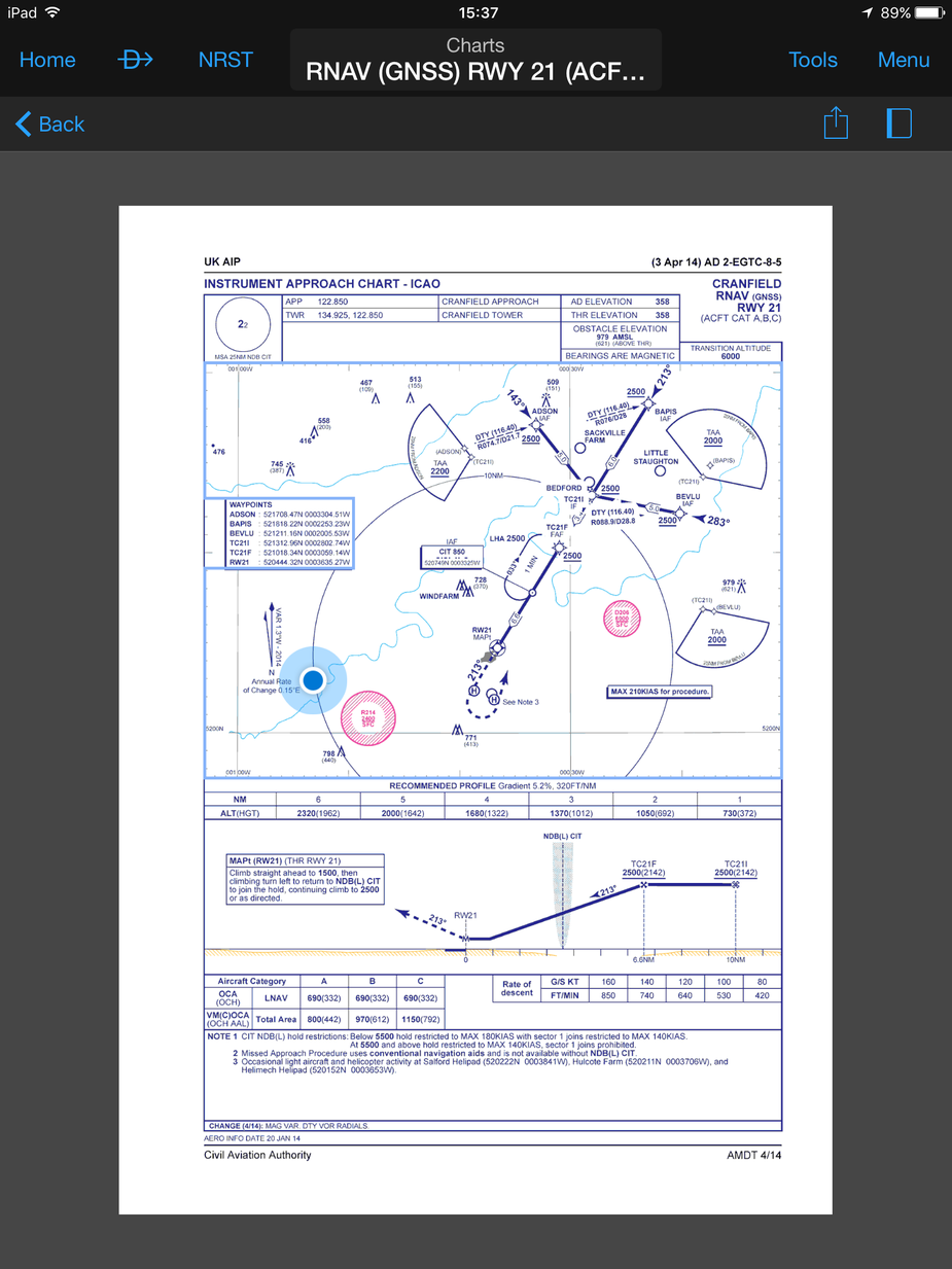
Attached is my lounge room georeferenced on the Cranfield plate….
But all the airport, airspace and nav data are included in the base subscription. You just need to pay extra if you need actual charts vs their maps which are fine or things like VFR approach plates in Germany.
The point is that, knowing Garmin, their “own” database is probably totally insufficient for real VFR flying.
It took Skydemon many years to get to a point where most of the kinks have been ironed out. VFR flying is a delicate subject and nothing short of the very best charts will do.
Bosco you are probably right I am not best placed to judge pure VFR usability however I think this will continue to improve. They are devoting huge resources to this and integrating with their cameras, watches and now panel mount transponders.
Would be interesting to have someone do a side by side test of the two for VFR flight.
Garmin obviously have very good obstacle and terrain databases but not sure how the human features material compares.
I have just never managed to fall in love with Sky Demon. It works but I don’t like using it.


