
Thank you arj1, it is a starting point but not quite what I had in mind but help with research
That CAA table is here
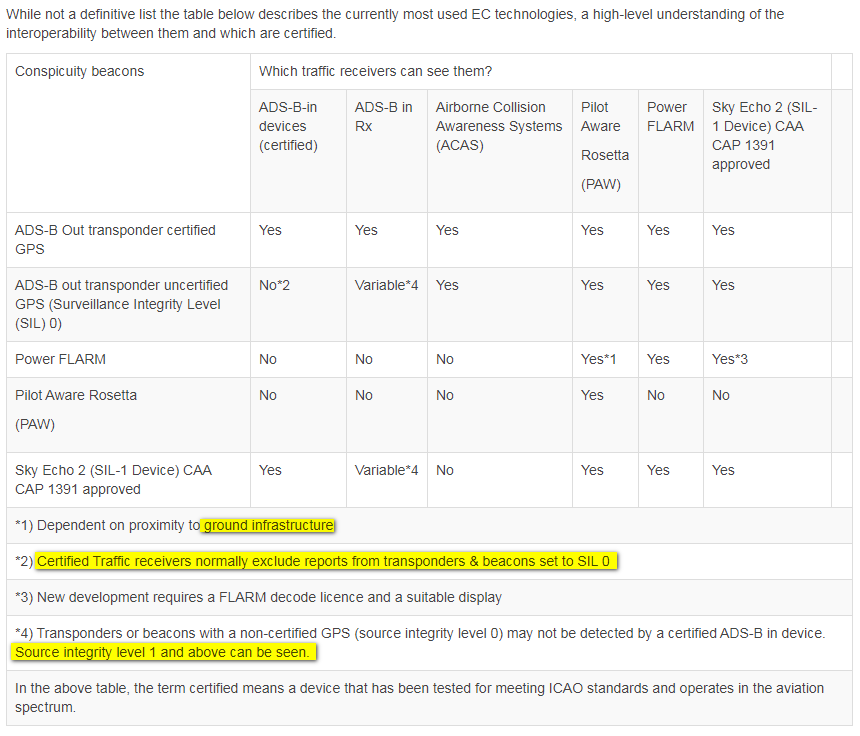
I have marked up some areas of “special interest” (where I smell some disingenuity):
1) “ground infrastructure” are ground stations; these are sparse and opinions vary on the future viability of this aspect (it’s not free to run)
2) I think this is correct except “normally” should be “always”  although actual proof will be hard to get
4) “May not” should be “will not” although actual proof will be hard to get; also SIL=1 “can be seen” is unknown with current hardware, until somebody does some tests and posts the results
The table misses out two things:
On the last one, this list was posted on a UK site as what Skyecho 2 can see
Mode-C (Bearingless)
Mode-S (Bearingless)
Mode-S / Multilaterated (3D)
OGN Glider Tracker Devices
FANET
PilotAware
but it is basically bollox. It should be
Mode-C (no bearing and no distance i.e. near-useless*)
Mode-S (no bearing and no distance i.e. near-useless*)
Mode-S / Multilaterated (3D) but with huge (FR24-sized) lateral position errors, and dependent on ground stations*
OGN Glider Tracker Devices
FANET
PilotAware (is this correct? only PAW can see PAW)
* these are good for only one thing: a climb or a descent, which is not much use under 2500ft CAS
It’s a great pity that nobody is now doing a ZAON-type box which shows some sort of bearing with Mode C/S targets and which could potentially receive all the other stuff, including Flarm on which the patent has expired and the packet format has been reverse engineered – notwithstanding that Flarm power is very low and reportedly of little use for fast powered GA against gliders.
However, such a box would still not be able to legally feed any panel mounted certified traffic display, plus you have the potential problem of merging targets which are emitting both Mode C/S and uncertified ADS-B OUT. I might have a go at that one day, but while selling it will be no problem, it won’t be possible to have it legally (openly) installed.
There just isn’t a good solution. I firmly believe that an active TAS like the Garmin/L3/Avidyne products show the biggest % of traffic, but they are expensive, at some 10k+.
The other thing which isn’t known (or nobody is posting it) is how much a jet airliner can see. They can definitely see your Mode A/C/S transponder, but can they see any ADS-B? This is quite relevant because a lot of people, especially in the UK it seems, are looking at using one of these boxes instead of a transponder (especially given the CAA’s crazy busts policy) and then if the pilot screws-up big-time and goes into some CAS, or gets close to some CAT plane in Class G (basically everything going into say the Scilly Isles, and countless provincial airports around Europe)…
The silence on a lot of this is deafening, as the saying goes.
Peter wrote:
but it is basically bollox. It should be
Mode-C (no bearing and no distance i.e. near-useless*)
Mode-S (no bearing and no distance i.e. near-useless*)
Mode-S / Multilaterated (3D) but with huge (FR24-sized) lateral position errors, and dependent on ground stations*
OGN Glider Tracker Devices
FANET
PilotAware (is this correct? only PAW can see PAW)
As far as I am aware SE2 sees ADSB out and FLARM and that is all
Peter wrote:
Can you point to the text which states that no certified ADS-B IN (i.e. Garmin Avidyne L3 Honeywell, taking the GA context) displays SIL=1 emitters?
From RTCA DO-317B Minimum Operational Performance Standards (MOPS) for Aircraft Surveillance Applications (ASA) System, the following is required for a certified device to display an ADS-B target:
2.2.4.1.2 Traffic Requirements for EVAcq or AIRB
An EVAcq or AIRB traffic track shall (2140) only be provided to the CDTI interface
when:
a1. Traffic and Ownship are on ground and traffic is reporting valid horizontal
position with a NACP of 7 or greater (< 0.1 NM).
OR
a2. Traffic or Ownship is airborne and traffic is reporting valid horizontal position
with a NACP of 5 or greater (< 0.5 NM).
AND
b. Version 2 traffic is reporting an SDA greater than 0.
AND
c1. Traffic is reporting valid horizontal velocity with a NACV of 1 or greater (< 10
m/s).
OR
c2. (Optional) Version 0 traffic is reporting valid horizontal velocity AND a
NUCP
OR
c3. (Optional) ADS-B/ADS-R (not TIS-B) traffic is reporting valid velocity, and
velocity quality can be ensured to meet 10 m/s accuracy based on derived
velocity using the ADS-B position messages.
OR
c4. (Optional), TIS-B traffic is reporting a NACV of 0. The reported horizontal
velocity and track angle for these tracks will only be used for TSAA alerting
purposes. Velocity and track angle must be considered invalid for other
applications. These tracks may be displayed as non-directional symbols.
OR
c5. (Optional) Airborne 1090 MHz ADS-B traffic is identified as a duplicate
address track. Since horizontal velocity and track angle are considered invalid,
these tracks may be processed without track estimation and displayed as nondirectional
symbols.
AND
d1. Traffic on ground is moving and a position message has been received within
the last 11 seconds.
OR
d2. Traffic on ground is static and a position message has been received within the
last 25 seconds.
OR
d3. Traffic is airborne and a position message has been received within the last 25
seconds.
A description of each of the applications follows from RTCA DO-317B:
Enhanced Visual Acquisition (EVAcq): CDTI provides traffic information to assist the
flight crew in visually acquiring traffic out the window. This application is expected to
improve both safety and efficiency by providing the flight crew enhanced traffic
awareness. Refer to DO-289 for a complete EVAcq description.
Basic Airborne Situation Awareness (AIRB): CDTI provides traffic information to assist
the flight crew in visually acquiring traffic out the window and provide traffic situation
awareness beyond visual range. This application is expected to improve both safety and
efficiency by providing the flight crew enhanced traffic awareness. This application also
provides Flight ID and ground speed of selected traffic. Refer to DO-319/ED-164 for a
description of the AIRB application.
This document modifies one aspect of the operational concept described in
DO-319/ED-164. The ASA MOPS version of the AIRB application allows for display of
ground traffic including ownship.
SIL will be used to define the probability of the reported horizontal position exceeding the radius of containment defined by the NIC, without alerting, assuming no avionics faults. Although the SIL assumes there are no unannunciated faults in the avionics system, the SIL must consider the effects of a faulted Signal-in-Space, if a Signal-in-Space is used by the position source. The probability of an avionics fault causing the reported horizontal position to exceed the radius of containment defined by the NIC, without alerting, is covered by the System Design Assurance (SDA) parameter.
As far as I am aware SE2 sees ADSB out and FLARM and that is all
I reckon that is spot on
Version 2 traffic is reporting an SDA greater than 0.
That seems to settle that one for the certified (TAS/TCAS1) boxes then; I can’t imagine they would have implemented that incorrectly.
However, where in the system is this filtering done? I recall a past discussion of this precise aspect, and recall a suggestion that it is the display device (and not the receiving device) is doing the filtering, and this might make it possible for an old (pre-dating ADS-B e.g. KMD550) display to display the whole lot. EDIT: here. Admittedly this isn’t relevant to current panel mount hardware.
Peter, i think you’re getting you stuff mixed up.
The two systems at the centre of all the fuss are Pilot Aware (Rosetta)
SkyEcho2.
These suffer massively from opinion mostly biased in which camp someone has invested.
This obviously appears also from those who have invested tens of K in TAS.
In summary
Pilot Aware is complemented with ground stations.
Within range of these it can see Mode C, Mode S,
Flarm, another PilotAware, Or ADSB.
However it only emits ‘PilotAware Signal’
Skyecho can see ADSB and Flarm.
It emits ADSB.
So based on that, you get what is the most appropriate for the situation. Everyone is different.
If like me you want to be as reliably as possible SEEN. Then use an ES ADSB transponder connected to a WAAS GPS. To be as reliably as possible SEE as many possible types and oprions get Pilot Aware.
If you don’t have/want/can’t arange ADSB, you’re better with Skyecho which will provide the ADSB for you but I can’t see it being as good as an ES TXPDR.
Then you have ro choose if seeing ADSB and Flarm is enough.
If you cant fit or afford TAS surely tjis is a good thing.
I don’t give a crap that airliners cant see my ADSB because they can see my Mode C/S surely?
And in any case at that point apart from a couple of occations I have only ever been near CAT under radar control, so it could all be switched off at that point.
NCYankee wrote:
SIL will be used to define the probability of the reported horizontal position exceeding the radius of containment defined by the NIC, without alerting, assuming no avionics faults. Although the SIL assumes there are no unannunciated faults in the avionics system, the SIL must consider the effects of a faulted Signal-in-Space, if a Signal-in-Space is used by the position source. The probability of an avionics fault causing the reported horizontal position to exceed the radius of containment defined by the NIC, without alerting, is covered by the System Design Assurance (SDA) parameter.
So SIL is used with a completely different meaning than in all other safety-critical systems engineering!? Sigh.
What is usually called SIL (System — or possibly software — integrity level) appears to be similar to what is here called SDA…
Within range of these it can see Mode C, Mode S,
It can’t (usefully); see above.
This obviously appears also from those who have invested tens of K in TAS.
Sure; myself included However I am far from the only one. Most modern “IFR” planes have these systems factory fitted. It isn’t “tens of k”, although I think the original Honeywell KTA870 traffic box did cost about 25k.
Then use an ES ADSB transponder connected to a WAAS GPS.
Agreed. I would do this with a GTX335.
Is there a coverage map of the ground stations, for various altitudes?
Half of this stuff belongs here This thread is really for the “portable” boxes. But for inter-operability this can’t be easily divided.
Despite PAW supposedly being portable, mine is less so as I’ve tied it into a switchable intercom feed, aircraft aux power and have tidied away additional twin antenna wiring.
I’m about as far from being an expert as can be but as I see it, if you were ADSB out………
I now should reliably ‘see’ you.
As I am Mode C, Mode S you should reliably ‘see’ me with superior kit.
This would work with Pilot Aware and Skyecho.
That’s all we need for the usual pinch points unser the londin TMA and general UK VFR
The last thing I need is MAC with a prominent Forum Owner.
The question of ground stations at that point is irrelevant, as only I need them for additional benefits/features from Pilot Aware. (Such as more traffic types and weather)
If understand correctly the concern
(quite rightly ) is whether your system will detect ‘ADSB only’ for when someone is without a transponder and buys only Pilot Aware or Skyecho?
I have only seen posts where it has gone into confusing detail with no definitive answer.
Which is why upgrading my transponder and supplementing with PAW was the best option for me.
I have seen a map of ground stations but will have to look for it tomorrow. As for altitude coverage surely once we’re high enough for that to be a concern would we need it?
I suppose it may be helpful for IFR airways enroute weather.


