Peter wrote:
How did the RAF integrate FLARM into their cockpits? How was the audio connected up?
Not sure about the tutor or the BBMF, but in the Tucano IIRC its a portable powerflarm unit.
Peter wrote:
Does it show azimuth on Mode S targets?
Sadly no. Just altitude and an estimate of distance.
Sadly no. Just altitude and an estimate of distance.
I wonder why they went for Mode S only, when the same info can be had from the Mode C packets. AIUI, Mode S duplicates the Mode C pressure altitude so even if you turn off the pressure altitude on say a GTX330, that data still gets sent out on the Mode S.. is that right?.
The unfortunate aspect of this is that the portion of the GA community which is most likely to hit you (the low level flyers) is also the least likely to be flying with Mode S.
However, without azimuth you don’t know which way to look. I use the active TAS all the time to look for aircraft in proximity and the azimuth info is priceless. They are very hard to spot even with that. I did a flight at the weekend with my two sons and it really showed how hard it is to see people. In one case, I even told the other pilot I was at his 9 o’clock range 1 mile (we spotted him eventually; he was indeed at our 3 o’clock, same direction and altitude) and it still took him ages to spot us, despite our background being just the sea+sky.
Peter wrote:
AIUI, Mode S duplicates the Mode C pressure altitude so even if you turn off the pressure altitude on say a GTX330, that data still gets sent out on the Mode S.. is that right?
Interesting question. Does anyone have the relevant TSO/ETSO to hand?
Peter wrote:
I wonder why they went for Mode S only, when the same info can be had from the Mode C packets.
My guess is because it’s a lot easier to filter out your own transponder. My old ZAON unit had huge issues with locking on to the installed transponder and alerting about a phantom target 0.5 miles behind…
Peter wrote:
However, without azimuth you don’t know which way to look.
Yep, it’s not great – I suspect that’s why the RAF installed TAS and FLARM in their tutors.
LXNav also offers ENL option (engine noise level) and IGC flight recorder.
Can someone explain what they are ?
The IGC flight recorder is a secure datalogger mainly used to record the flightpath of a glider, any pre-flight declaration of intent, and some ancillary data. This allows the pilot to prove that they have flown the route they chose or were assigned, and without infringing controlled airspace. From this a score can be derived for their performance, perhaps just for personal satisfation, but the security/authentication involved is sufficient for the log to act as proof in competitive or record-breaking flights, and the log file can be easily and conveniently downloaded and emailed etc for this purpose.The ENL is used to prove that the engine has not been started during the flight,or to permit adjustment of scoring if it has. They are not related to the collision avoidance aspect of Flarm but including them makes for an attractive package.
Alan
Robin_253 wrote:
PAW (Pilotaware) is another closed source and proprietary collision avoidance system.
It depends on whether you are talking about the PAW protocol (pilot3i) or the PAW device itself which may or may not include the PAW bridge.
I built my own PAW device using the components described on their web site (raspberry Pi B+ incl box, U-blox7 GPS usb dongle, ADS-B receiver antenna & usb dongle, wifi usb plug, µSD card with PAW software/licence), excluding the proprietary bridge card needed for the specific pilot3i protocol. Whole thing cost less than €100. The proprietary part, the PAW pilot3i protocol and bridge card for the Raspberry, is listed on their web site for about an additional €100. The entire package can be purchased prepackaged, incl PAW pilot3i bridge) from them for under €200.
So mine is essentially just an ADS-B-In device that uses wifi to forward data to one of the various tablet software packages such as SD, EVFR, etc. It needs a tablet-size power supply so I just bound it to a power-bank that I can either recharge on the ground or connect to a USB power supply in the aircraft. It doesn’t pick up A/C, just Mode S squitter signals.
CHF, I’m surprised you have got that working. Apart from the earliest trial systems, I’m pretty sure PAW doesn’t work unless you buy their own “bridge” card, whether you want to use their air protocol or not. In fact, nowadays they won’t even sell you an initial software licence without buying their card. In theory the radio protocol is “open” so that others can implement compatible devices from scratch but the protocol document which was published (eventually and I suspect reluctantly) on their website is clearly an incomplete work-in-progress and not really fit for purpose. So although they started off making a big fuss about how “open” their system was, I don’t think it has really ended up that way. It’s still an interesting product and the price is right.
Alan
chflyer wrote:
Is your Cirrus EASA-reg, Steve?
Yes it is. F registered.
PetitCessnaVoyageur wrote:
What is PAW ?
Could we know more about LX Nav and their products ?
PowerMouse, FlarmMouse… Sounds interesting. What kind of installation ? Which antenna ? Where do you source the power from ? How well does it work ?
What I have is the Pilot-aware Hardware placed into a small metal box. This metal box is maybe slightly larger than an A5 piece of paper. Inside is a battery pack to power the Pilotaware – it powers the PAW for around 8 hours from full charge to empty. The GPS antenna is the remote antenna, as is the ADS-B antenna. These both have magnetic feet which means they attach to the box. There is one antenna which transmits the PAW signal, this is velcroed to the B pillar. In total, only the one wire actually goes away from the box and that is this last cable to the PAW transmitter.
As the aircraft is composite, I have no issues with GPS signal blocking. The power cable to the heart of the PAW (the Raspberry Pi 2B) has an on / off switch, before starting up, I switch this on. Then my phone running Sky Demon / Sky Map connects to the Wifi Hotspot prepared by the Raspberry Pi and displays traffic on it, assuming I have activated the traffic system. Attached is a screenshot of Sky Map showing an ADS-B target (green arrow), a Mode C target (red ring, showing proximity with altitude difference) and a Mode S target (brown ring, showing proximity, altitude difference and aircraft registration). The colours of the Mode C and Mode S target show the proximity – i.e., the Mode C target was closer to me.
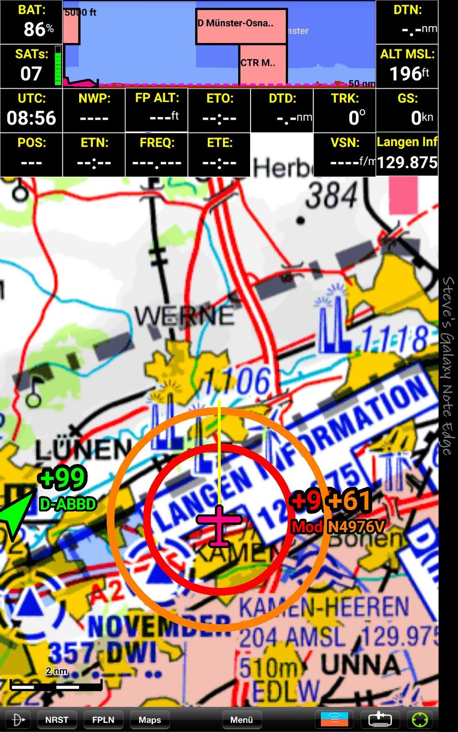
- Mode A (proximity)
- Mode C / S (proximity and altitude differential)
- Flarm (exact position)
- ADS-B (exact position)
- PAW (exact position)
equipped aircraft.
Additionally Flarm equipped aircraft will see my exact position, as will other aircraft equipped with PAW.
The total cost for PAW was around 200 quid, add to that the 700 euros for the Flarm and I have a system which is capable of showing me most aircraft which have some sort of transponder fitted. I find it amusing to be aware of the conflicting aircraft before FIS tells me…..
Peter wrote:
However, without azimuth you don’t know which way to look. I use the active TAS all the time to look for aircraft in proximity and the azimuth info is priceless. They are very hard to spot even with that. I did a flight at the weekend with my two sons and it really showed how hard it is to see people. In one case, I even told the other pilot I was at his 9 o’clock range 1 mile (we spotted him eventually; he was indeed at our 3 o’clock, same direction and altitude) and it still took him ages to spot us, despite our background being just the sea+sky.
That maybe so but the thing about collision avoidance is that in reality you never really need to know where the conflicting traffic is coming from / heading to, the only information you actually need is differential in altitude because it doesn’t matter which direction two aircraft are flying, if they are at differing altitudes, they will never collide. So for years I’ve flown with my MRX and it’s been invaluable insofar that it warns me if any (transponding) aircraft in the area are at my altitude (or similar). All I need to ensure is that I have a couple of hundred feet difference between myself and any other transponding traffic and job done. However the usual caveat about looking out for non transponding aircraft applies……
What I will agree is that aircraft are generally incredibly hard to spot. Beyond 2NM – forget it, you won’t see any GA. between 1 and 2 NM, 30% chance of spotting them, under 1NM this rises, but I have seen ADS-B traffic indicated on my screen, less than a mile away and still been unable to spot them……
It has occurred to me that Robin’s post above is most likely the reason why nobody is making a certified product which combines FLARM with “conventional TAS” i.e. Mode A/C detection with altitude and azimuth.
Commercially it would be seen as a potentially disastrous business model. It would be like Rolls Royce making jet engines and my grandmother controlling the Type Certificate for them. Only an idiot would get into a business like that.
If such a product could be made, it would be very attractive. IMHO most pilots with any significant money to spend on flying don’t really want a ton of velcro-attached / cigar-lighter-powered stuff in their cockpit, with traffic presented on an Ipad whose audio output “may” come through bluetooth direct to your bluetooth equipped headset… when none of the batteries involved have gone flat, etc…
As this thread shows, there is an “uncertified electronic conspicuity solution” for every pilot on the internet  One can have hot debates about the adoption of these… many previous threads on that already e.g. here