
When flying IFR through Europe, how would one know the needed COMMS radio frequencies for the enroute phase? For VFR I can find them on the map, also my VFR planning software prints it nicely on the PLOG. But for IFR they're much harder to find. I see some of them on the Jeppesen Enroute Chart, but they're quite obscure...
You don't. You have to rely on being passed from one ATC to another. There are just so many frequencies in use and when using one of the Jeppesen charts, you just get a random one which seldomly is the right one.
The Garmin GPS also have an ARTCC page with the frequencies but what good is a list of 25 frequencies of which one might be the correct one (if their database matches reality which it doesn't always do)?
When at loss, you can look for nearby airports and the RADAR frequency on the chart or contact FIS or as a last resort 121.5MHz.
When at loss, you can look for nearby airports and the RADAR frequency on the chart or contact FIS or as a last resort 121.5MHz.
Yeah, I'm teached to listen out on 121.5 on the 2nd radio. I'm also told to switch back to the previous frequency when lost.
I thought it would be nice to have the frequencies prepared, and when handed over you just have to make the standby freq active... But apparently it doesn't work like that in real world IFR :-)
I thought it would be nice to have the frequencies prepared, and when handed over you just have to make the standby freq active... But apparently it doesn't work like that in real world IFR :-)
It's rather complex and very dynamic. Some areas might be under military ATC at certain times, other places have additional sector frequencies during rush hours and then everything depends on your present altitude. It's often not predictable what frequency you are going to get.
Yeah, I'm teached to listen out on 121.5 on the 2nd radio.
I don't think there is anything in the regulations suggesting you to monitor 121.5. I never do it. What good could it do? If somebody needs my help, ATC know where I am and how to reach me.
I'm also told to switch back to the previous frequency when lost.
Yes, I started my IFR career with Collins VHF that don't memorize the previous frequency. That sucks.
My standard technique for no contact is to look for nearby towered airports and either contact them or their RADAR frequency if listed on the IFR approach plate (and I happen to have access to it).
The other day when I flew to Egypt, I had three frequencies for Cairo ATC, none of which worked at FL095. 
In Europe, one is always assigned the next frequency when flying IFR in CAS because the whole flight is "controlled".
Your Eurocontrol flight plan got transmitted to all units along the route, plus dep/dest airports. So, in theory, you get seamless handovers.
One problem is if ATC forgets about you (which is rare but does happen) and you fly out of the current unit's range. In that case you have a theoretical "lost comms" scenario under which you are entitled to continue flying the filed route (with some national variations on the theme) but it's not exactly wise to immediately set 7600. I don't recall what I did last time this happened but I think I would call up the regional FIS frequency. Usually you get an airliner relaying an ATC call for you giving you the next frequency. 10 years ago, this kind of "lost comms" used to happen a lot in France on weekends but that was VFR which is a completely different situation.
The funny thing about IFR is that you could just jump in the plane and take off, without having a plog or anything else. You need to know what to do after takeoff (the departure clearance, so you need the SIDs etc) but after that ATC give you each waypoint. I do know people who seriously claim to fly that way...
Others take off with the plates and a waypoint list emailed to their phone by the flight plan filing site (e.g. EuroFPL). No charts...
The problem is that very occassionally you get given an airway name to follow, and then
The problem is that very occassionally you get given an airway name to follow, and then
... You buy a Garmin650/750!
The problem is that very occassionally you get given an airway name to follow, and then
The solution is simple: you only need ICAO level 4 English, i.e. be able to spell your name. If you're playing stupid enough, they will eventually guide you using headings
The funny thing about IFR is that you could just jump in the plane and take off, without having a plog or anything else. ... Others take off with the plates and a waypoint list emailed to their phone by the flight plan filing site (e.g. EuroFPL). No charts...
I have JeppFD on the iPad which knows about airways but that's the only thing I carry. RocketRoute generates a plog and emails it to my phone/iPad but I rarely use it, only to compare the file flight plan to the clearance. Once the relevant waypoints are in my GNS430 and as a backup in the yoke mounted Garmin 695, they become my plog with continuous ETA and LFOB calculations. The plog is based on your Eurocontrol flight plan and one very rarely flies the planned route.
The solution is simple: you only need ICAO level 4 English, i.e. be able to spell your name. If you're playing stupid enough, they will eventually guide you using headings
That may not work in Spain, where ATC are often ICAO English Level -1
Personally I like to have a view of the general area I am flying through, showing airway intersections, and regional FIS frequencies.
I do often keep the 121.5 frequency standby and you would be amazed how often you would hear ATC trying to contact an airline that they lost in the handover. ATC will go on the guard frequency 121.5 and call them. You hear them calling the lost aircraft quite often. It is also how I was instructed during my instrument rating training to do.
I recently flew to Pontoise and could not get the pilot controlled lights to go on while descending on the ILS to a still pitch dark airport. I tried several frequencies such as the tower frequency and in the process lost the frequency of the controller I talked to just before being cleared to land and ... forgot to write that frequency down. So, then I just moved over to the 121.5 frequency and asked if there was anyone on guard and got the frequency to establish contact again. No big deal.
I never use a plog as indeed the flight is dynamic with directs offered to you often already right after takeoff. I fill in the full flightplan with all the waypoints and airways in the Garmin Perspective and have it also at hand on my iPhone/iPad. That's it. While planning I get the full route length/duration time including the forecasted winds aloft for each route segment from my flightplan filing software. The directs give me a shorter route and since I modify the flightplan loaded in the Garmin Perspective while flying I end up knowing how long I still have to fly.
Here is a little IFR flight, FL120, which I did the other day - Shoreham EGKA to Coventry EGBE
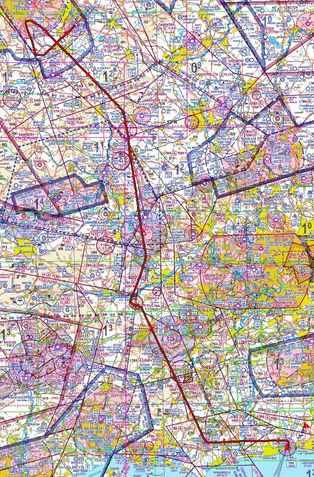
The departure clearance was just "after departure, left turn to Goodwood, remain OCAS, squawk 5454, contact London Control 133.175".
The frequencies used enroute were
133.175
134.125
121.275
133.075
118.050
IIRC, the last one was Birmingham and the others were London Control. All were issued over the radio. AFAIK none could have been looked up.
Track in thick red. The last bit was vectoring to the ILS at EGBE.


