I hope you decide to come Patrick! Previous ones were great fun! 
I might NOW make this trip. Our aircraft PA28 Arrow IV N2136E was previously booked by another, but has become available for me.
Anybody interested in RHS (maybe cost share of some %) from EGCF (Sandtoft) or pick-up Belgium / Germany (make it a fuel stop).
Last time I went that way (Mali Losinj) I stopped EDTY Schwabisch Hall (nice) for fuel and made a night stop in an equal nice nearby modest hotel and crossed the following day at the Austrian end.
I now have SkyDemon on iPad (plus Garmin aera 795 & panel 430) and may consider a GAFOR route. This may negate a fuel stop.
Not flown an Alps GAFOR route before and am nervous about them. Sure there is no reason to be, but I am.
Duration is 6.5 hours to ‘most touch-down’.
IAS is 140 kts.
Very early planning / thinking stage at the moment even approaching this twelfth hour.
I prefer a day eitherside for these trips, say flying out Thursday 3 and returning Mon 7 or even Tue 8.
My plan is to fly there Friday 4th Sep i.e. a day before (at a guess) most of the others.
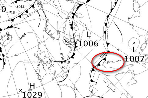
The MSLP chart isn’t out yet but the Thursday 3rd Sep one is and it shows a possible low cloud over LJPZ

Of course the one thing which is more or less sure is that this forecast is wrong 
Are you planning the GAFOR routes @WarleyAir because you want to fly lower i.e. no oxygen?
Thinking ATPIT rather than a definite ‘plan’, however, as it happens, I have no oxygen.
There is a ‘set’ belonging to the group, but it’s stuck in a box uncared for and guess needs some TLC, not to mention filling and testing.
I was going to get this done way back, but didn’t get onto it !!
Last time (Mali Losinj) I crossed at the Austrian end but had to go to a v high FL to stay ‘on-top’.
I was a bit concerned and kept a close watch on myself (if indeed one can pre-empt hypoxia).
The other thinking is that the more direct route GAFOR offers may avoid a fuel stop.
But not sure I want to put a near six hours leg in, not to mention cutting it fine on fuel.
GAFOR routes ‘show’ on my new SkyDemon, but if I ‘lose’ that, the other Garmin devices do not show them.
Really don’t want to be in a GAFOR valley and lose GAFOR guidance!!!
Going VFR via eastern Austria is a long way – can’t do that on full tanks unless really good tail winds – and can’t bank on that.
Can those who plan to arrive post here or email me please?
It will be easier to coordinate when we get there.
I already have a number who contacted me by email.
Do Slovenia and Croatia publish any VFR charts? The only ones I have are the Jepp 2013 ones, and the various airport charts.
WarleyAir wrote:
Really don’t want to be in a GAFOR valley and lose GAFOR guidance!!!
It’s really not that difficult! The first time I flew through the Alps I had an even faster aircraft than yours (PA32R). If you are well prepared and the weather is reasonably good, you have nothing to worry about. You could even set user waypoints on your 430 as a backup. In fact, in your situation, I would probably use the 430 as the primary means of navigation and the iPad as backup!
It depends on whether you are flying the canyons below a cloudbase. In that case you would not want to turn into the wrong canyon…
I went into some of this here but then I have topo maps on a GPS. Obviously the locals/regulars know the area and don’t need any of this…
Also there isn’t a canyon which allows the Alps to be crossed at a low level, say a few thousand feet.
Both Croatia and Slovenia publish VFR charts regularly. Croatian is around 20€ (IIRC) and Slovenian used to be given for free.
I downloaded the slovenian one for free from their web, the croatian ones as well if I remember right.
I found the Slovenia VFR chart here
It doesn’t download. The URL is here but that isn’t a PDF and doing a “save link as” tries to save an .htm.
That was in Firefox. Chrome just hangs.
Can anyone download it and dropbox it to me, please? There are also the explanatory notes which don’t download either.