This is on a TB20 with propeller TKS. Of course I will never say I have any idea which TB20 it was.
For a 5kt speed loss:
For a 10kt speed loss:
The important thing is that a 10kt speed loss is equivalent to a huge loss in the rate of climb available at that altitude, so going up is not an option.
As expected, the pictures match the experience some people have had on a TB10 for the same speed loss.
I wonder what the corresponding pictures are like for a PA28, C182, M20J, M20R and the Cirrus.
How long in what kind of cloud?
A strip of ice on the leading edge of a fat wing probably provides little drag at a constant AoA (angle of attack). The drag to reducxe speed by 10kts must be mainly from antennas, tailplane etc. However if you increase the angle of attack, to climb for example, the drag must increase substantially. It also exposes different parts of the airframe to ice build-up. So I suppose the answer is to maintain constant AoA by increasing power, and then by slow descent.
If I’m getting light icing I always check the tailplane first (I can just see the end of it) as the buildup is more obvious as a proportion of it’s thickness. I’m more nervous of tail icing than wing icing.
The first looks like a freezing rain shower, the second like a Stratus cloud, no rain. We can play guess the cloud the ice is come from ;-)
…I wonder what the corresponding pictures are like for a PA28, C182, M20J, M20R and the Cirrus.
I would see 10-15 kts for the second picture in my M20J…..the difference is that my leading edge is much sharper than the relatively fat TB wing so I get that build up very rapidly…..not to mention what is happening on the even sharper tail plane…
I think the speed loss is not antennae etc as TedP surmizes, but rather mainly due to disruption of airflow causing reduced lift (at the normal AoA) thereby requiring an increased AoA to maintain altitude….and it’s associated aerodynamic drag
TB20 vs Mooney wings: Link
> The first looks like a freezing rain shower, the second like a Stratus cloud, no rain. We can play guess the cloud the ice is come from ;-)
I reckon the first was in a particularly wet Cumulus cloud, agreed on the second… Peter?
So where does pic2 scale between light rime to severe icing?
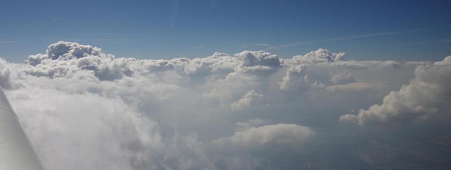
Pic 1 was picked up in 2 minutes in these cloud tops, at FL110 and -3C
Pic 2 was picked up in about 2 minutes in thick IMC, at FL150 and -5C.
No turbulence and no rain.
I think most people would call this “light icing” but you do need to have a viable Plan B which has to be either a descent into warm air or you know the IMC will end pretty soon. Icing is virtually assured (maybe not immediately) in thick IMC and -5C or so is the “best” place to get it.
Interesting you had no turbulence in the tops of that TCU. You would expect it to be quite turbulent…