Northwest of Mont-Blanc, it is airspace Echo up to FL175 as long as you are less than 3000 feet AGL.
Southeast of Mont-Blanc (Italian side), it is airspace Golf up to FL195.
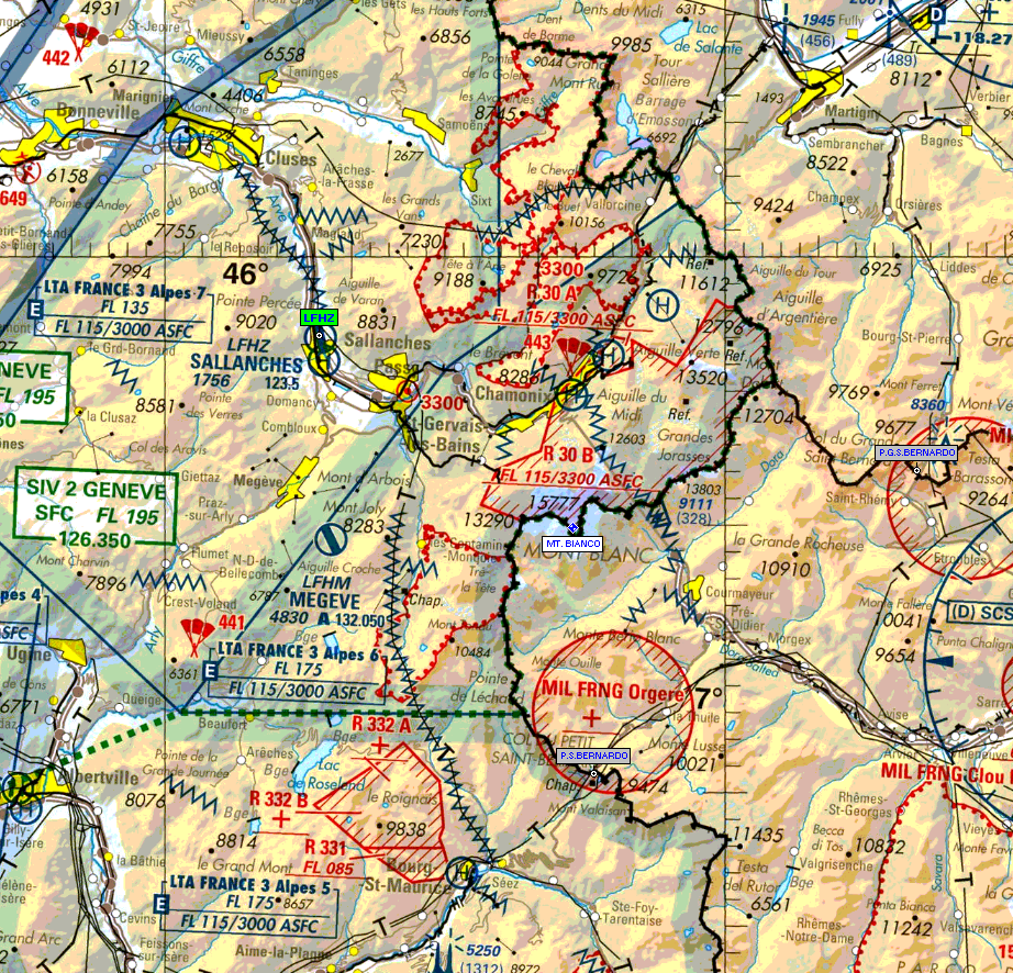
Thanks. I have this 2018 chart from France
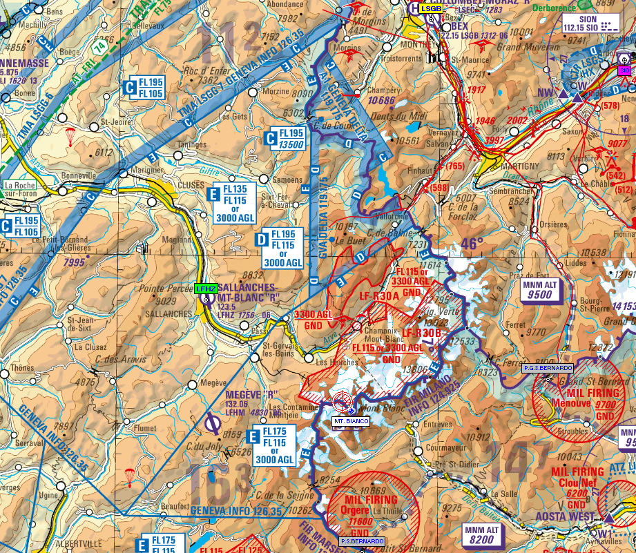
and this 2018 chart from Switzerland
What concerns me are those restricted areas, and whether the summit can be reached in practice from say DJL, FL160, without risk of some major diversion.
Current IFR chart from Jepp showing nearest intersections
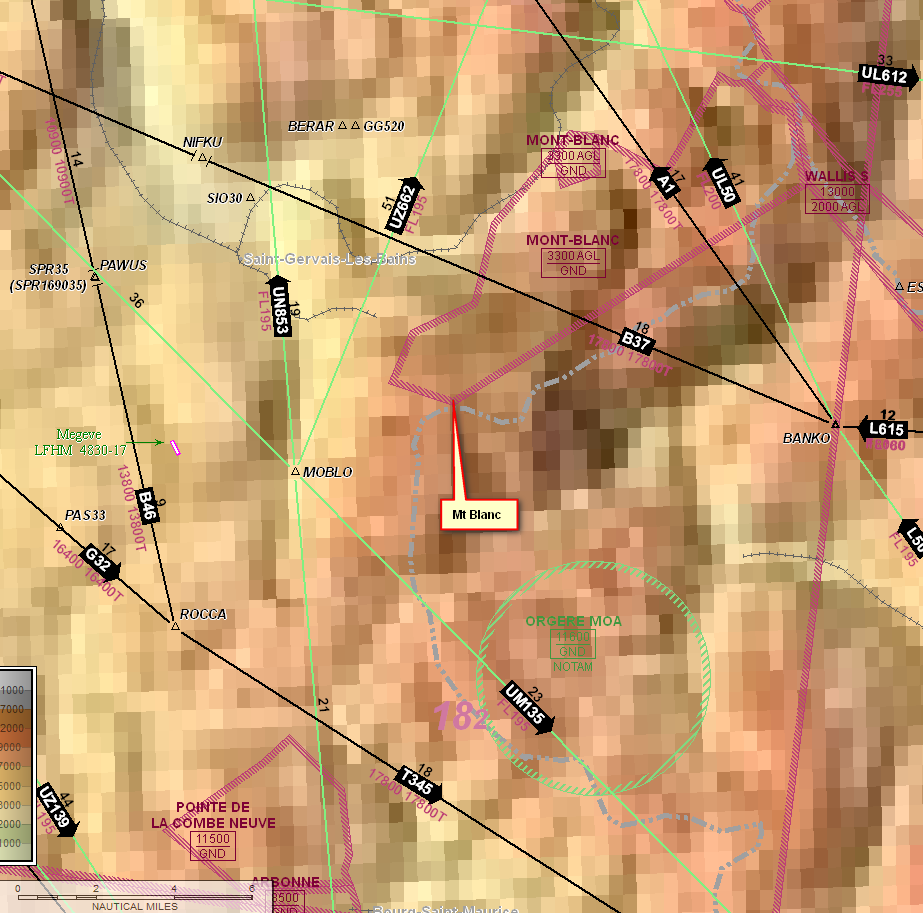
and this one shows DJL top left
This route validates
EGKA N0145F040 SFD VFR DCT KUNAV DCT ABB/N0151F090 DCT BILGO/N0151F090 IFR B3 VATRI G40 ARSIL B13 SOMDA A6 DJL A1 LISMO VFR DCT MOBLO DCT LISMO IFR DJL/N0151F090 A6 SOMDA B13 ARSIL G40 VATRI B3 BILGO H20 XORBI H40 NEBRU/N0150F120 H40 ABB VFR N20 KUNAV DCT WAFFU EGKA
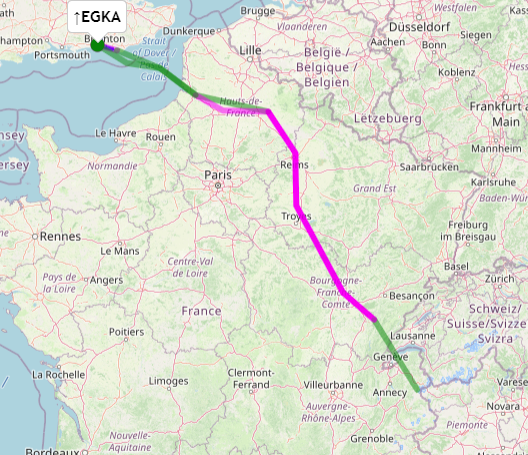
Shorter than the last one:
889.5 NM (direct: 0.0 NM, overhead n.a.") 
6hrs and a bit.
What is not to like?
The gotcha will be with that VFR section and what ATC will actually let me do. Does anyone here have any ATC connections? I wonder if @Guillaume knows.
It‘s tough understanding these airspaces with paper charts. And worse if they are outdated. But you can see the label for the relevant French LTA sector below Megeve airfield.
And same for restricted areas and so on. Zoom in using your preferred app and then tap on them to get the details. As mentioned, in the immediate vicinity of Mont Blanc, there is just one, and applies only to ultralight gliders. Also, R30B is not active this season. And R30A is very small.
Can one trust one of the tablet apps to have accurate data, where probably no GA pilot (who is likely to be a customer, and speaks English, and might be willing to report errors) has ever been?
I guess every tablet chart is more “safe” than a paper chart. SkyDemon has actually quite a good feedback community in Germany and Switzerland. I never found real major errors in the app, only small ones and they were fixed quite fast.
Peter wrote:
Can one trust one of the tablet apps to have accurate data, where probably no GA pilot (who is likely to be a customer, and speaks English, and might be willing to report errors) has ever been?
I think flying VFR leg O/R DJL-MtBlanc on SkyDemon “is safe”, IMO you should be more worried about the VFR leg O/R ABB-EGKA
You will not be the only guy there for sure, so open your eyes !
Thanks. I have this 2018 chart from France
and this 2018 chart from Switzerland
The (updated) Swiss map can be found here as well:
Thanks; I keep this thread updated with these links.
In 2018, somebody joined up the tiles into a big file and I run that on my tablet when flying in the covered countries. I ought to ask him for a more recent version
Can someone in French or Swiss ATC please advise whether that routing from DJN to Mt Blanc will be possible at all?
Or does anyone have a phone number for ATC which I can call tonight?
Thank you very much