Peter wrote:
Unless I can plot the elevations along the proposed departure route, I would circle around the airport. The valley is huge.
Peter, I am sure Aosta will be happy for you to climb in circles in the overhead. That is SOP in Alpine valley airports. At Sion these is even a “low performance” IFR departure under which you take off, climb in the downwind leg and turn back inbound once reaching about 6,000 ft. They are also v happy to allow climbs overhead VFR to gain altitude before heading out over nearby passes. I am sure Aosta will be similarly accommodating.
Can’t be 8000ft max as Grand St Bernard is 8200ft pass altitude, and your proposed pass is higher than that. Plus 1000ft for clearance.
Maybe plan a “tech stop diversion quarantine exempt” for 1min to look at webcams at Annecy or Annemasse? or further south in Italy if in doubts?
I don’t understand this strategy, for a TB20.
One plans this only in good wx.
A stable high pressure system.
Look at the airport webcams the day before.
Check them again the morning of the flight.
Fly there.
If overcast (actually very unlikely if one did the above) descend to the local MSA.
If still in IMC, fly back to Shoreham. Might refuel in say Colmar – hopefully the police won’t grab you; it is 24hr PN for immigration. Maybe Strasbourg, or even Le Touquet.
It is also possible to get someone to keep checking the webcam and send you texts about the cloud cover.
Can’t be 8000ft max as Grand St Bernard is 8200ft pass altitude, and your proposed pass is higher than that
In that case that website calculator is wrong. Wx is rubbish this week and next so plenty of time 
I would be looking for a lot more than 1000ft clearance
Peter wrote:
I don’t understand this strategy
You should be able to see MtBlanc summit and weather around it with your naked eye while walking on your aircraft wings (no webcams or no reports) from the following airports Annemasse, Aosta, Annecy, Sion, then you only have 20min of VFR to make it to the other side
In the other hand, if you believe in 3h forecast or you have realiable in-flight weather or clear sky as you pass overhead, it may work in one go !
Worst case you have enough fuel to get back to Shoreham without a blink
But then you will miss it if there is a “VFR flying window” that day 
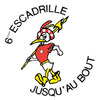
I just flew it out from Aosta on Earth
View from the peaks on the South side of The Valley abeam La Salle, about 11000ft looking back to Aosta.
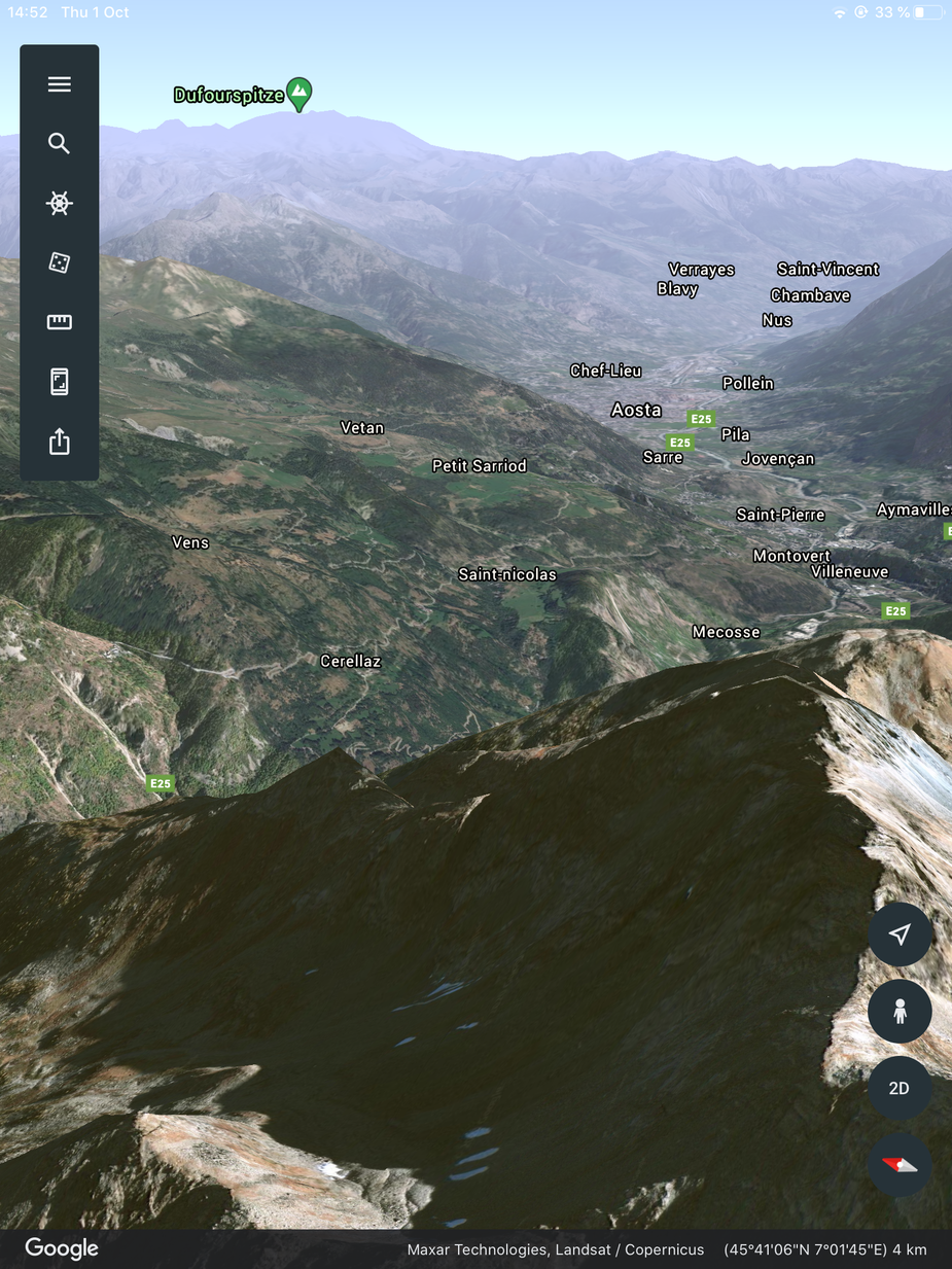
Looking NW towards Courmayeur from the same location.
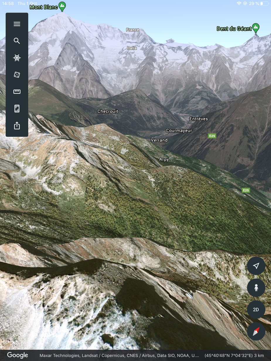
Heading NE from Cormayeur towards the pass, 11000ft
Looking N from the pass , 14000ft. Vevey and Lake Leman on the horizon
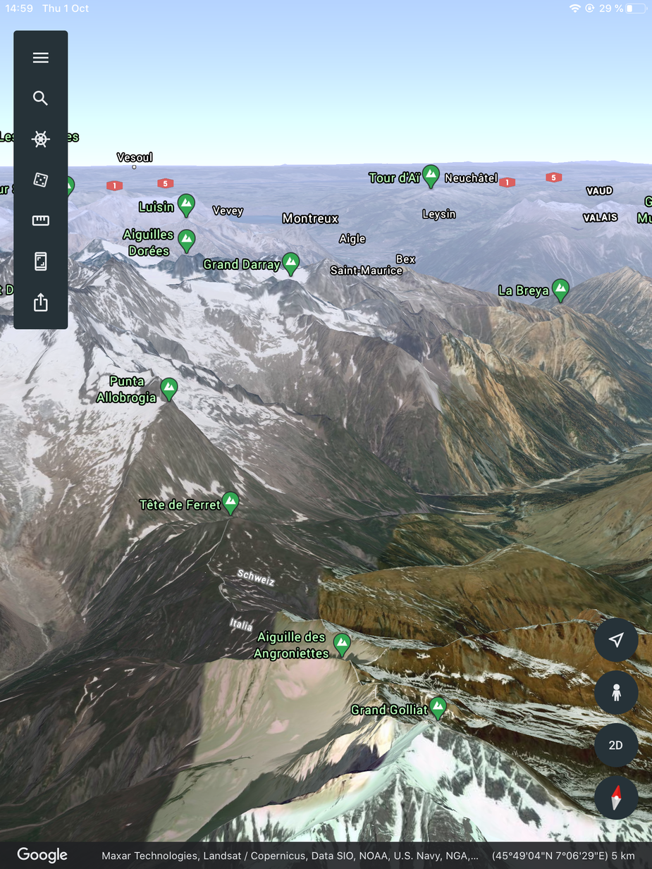
You will not need to circle. And if you do there will be plenty of opportunity
I don’t get the tech stop strategy either, and crossing the Alps involves more than “look at the webcam”.
MeteoSchweiz publishes forecasts for all the alpine routes broken down in three two-hour increments. If the ceiling & viz forecast is decreasing from open to difficult to marginal you just don’t leave, it would be pretty pointless. If the forecast is stable you do, provided there is no forecast or actual increase in wind speed, which is something that stopping at Annemasse and looking at the mountain won’t tell you.
Thank you all
MeteoSchweiz publishes forecasts for all the alpine routes
Which bit of the website? Also I get the impression this is not any standard route. It is just something I hacked up.
I am not doing stops before the Alps. Last time I did that was in 2004, going to Crete, at Wangen-Lachen, following “advice” from a UK forum sky god telling me “there are these things called mountain waves and they can kill you”. The end result was sitting at Wangen-Lachen in the rain for a few days, and then climbing out of there in an orbit over the lake, to FL129 (because Zurich would not allow VFR in its Class C) and ok we got some great scenery then, flying just above the terrain at FL129… Never did that again. The following trip, Santorini, was done direct UK to Trieste, and nowhere near VFR in Switzerland
Actually it should be “publishes” because you have to pay for it. You can see the route forecast in Skydemon, or behind the paywall at Skybriefing.com.
Your route is not an official route but if route 44 (Simplon) is open, it has +/- the same orographic characteristics as yours.
T28 wrote:
MeteoSchweiz publishes forecasts for all the alpine routes broken down in three two-hour increments.
Even for cross border routes? I only saw Sion/Lugano via Simplon pass or Samedan/Lugano? the other routes forecasted are standard inside Switzerland only, these may cover Leman-Sion which is only half story in Peter’s “personal route” and as always the problem is the second half, especially the Italian side in current winds….
Peter wrote:
I am not doing stops before the Alps. Last time I did that was in 2004, going to Crete, at Wangen-Lachen, following “advice” from a UK forum sky god telling me “there are these things called mountain waves and they can kill you”. The end result was sitting at Wangen-Lachen in the rain for a few days, and then climbing out of there in an orbit over the lake, to FL129 (because Zurich would not allow VFR in its Class C) and ok we got some great scenery then, flying just above the terrain at FL129… Never did that again. The following trip, Santorini, was done direct UK to Trieste, and nowhere near VFR in Switzerland
You are not going to Greece, you will stop in the Alps (just pulling your leg )
Any reason why IAP at Aosta is VMC only? training only? no ATC? need sing-off?