
Have the prices for the units gone up?
To me ever since the CAA 250 quid rebate the prices of Skyecho 2 seems to have rocketed.
£699 at some suppliers now.
arj1
I’m not trying to push this on anyone, and I did read you have it.
My thoughts, selfishly if you like, is that for a small outlay, and a little hassle, the more people that have PAW, tha safer my flying becomes. Thus safer for everyone.
From the PAW website…..
METARS that are uploaded to PilotAware users when in range of 1 or more of the 200+ ATOM GRID ground stations in Europe. This is a complimentary service from PilotAware.
METARS are broadcast from all the ATOM GRID ground stations. Current METAR’s from each individual European METAR location are uplinked every 15 seconds. A full set of available METARS will be available after approximately 5 minutes of being in range of at least 1 ATOM Station.
METARS are provided from all METAR sites within 150kms of the ATOM grid station to which you are connected. These are tabulated in distance order with the status as shown in the table below. The ICAO codes are translated into easily understood locations.
The status of each METAR location is colour coded for easy analysis.
METAR colour legend;
VFR: Ceiling greater than 3000 feet and visibility greater than 5 miles (includes sky clear).
VFR = >3000′ and >5 miles
MVFR :Ceilings 1,000 to 3,000 feet and/or visibility is 3-5 miles inclusive.
MVFR = 1000-3000′ and/or 3-5 miles
IFR: Ceilings 500 to less than 1,000 feet and/or visibility 1 to less than 3 miles.
IFR = 500-1000′ and/or 1-3 miles
LIFR: Ceilings are less than 500 feet above ground level and/or visibility is less than 1 mile.
LIFR = <500′ and/or <1 mile
METARs on the PilotAware Web Interface;
The status of each METAR location is colour coded for easy analysis.
GoTo Page
RULE KM NAME METARVFR 27 Birmingham_Intl EGBB 311520Z VRB06KT 9999 SCT018 SCT031 14/11 Q1015
MVFR 46 Gloucestershire_Arpt EGBJ 311540Z 22010KT 9999 VCSH SCT012 BKN016 14/11 Q1016
VFR 52 Oxford_Arpt EGTK 311520Z 24011KT 9999 FEW010 SCT024 14/11 Q1016
VFR 53 Brize_Norton(RAF) EGVN 311540Z 24007KT 9999 FEW018 SCT026 14/11 Q1016 BECMG BKN022 RMK BLU BECMG WHT
MVFR 74 Nottingham/E_Midland EGNX 311520Z 22012KT 9999 BKN023 14/10 Q1014
VFR 80 Benson(RAF) EGUB 311450Z 22010KT 9999 // SCT023/// 14/11 Q1016
MVFR 89 Shawbury(RAF) EGOS 311450Z 22011KT 9999 OVC025/// 14/10 Q1014
METARs on the PilotAware RADAR Screen ;
As well as appearing on the METAR Page, METAR’s are also shown on the PilotAware RADAR Screen to help you understand if you are flying into Marginal VMC or worse, conditions and take appropriate action as you see fit.
To see all METAR stations and wind feathers within 150Km, the PilotAware RADAR screen will have to be “zoomed out” horizontally. As PilotAware shows more traffic types than any other EC device, the traffic screen will be very busy if all traffic filters are set wide open. It is therefore recommended that the vertical scale is set to no more than 2000 ft to filter out the high-flying airliners being detected using ADSB and Mode-S/3D the locations of which are unnecessary.
For normal use, the PilotAware RADAR Screen should be set to a few KMs to act as an effective Situational Awareness Screen.
A PilotAware RADAR Screen zoomed out to 60Km radius, shows METARS and wind feathers.
I don’t have time to research the exact wording, so don’t want to say definitely for risk of being incorrect…..
But I have the PAW wifi dongle added i the unit.
This allows me to have a GSM feed from my phone or onboard GSM wifi unit (always carried)
When Gsm is available, wx data and other stuff (can’t remember what) is also uploaded via this second path for resilience.
GA_Pete wrote:
If people stopped to think for a minute, if everyone fitted PAW, everyone would see everyone, for a few hundred £. Plus get Wx.
I’ve already got one! The question is regarding WX – what do you get?
Unknown target completely unseen, out of sight, on collision course. vs unknown target warning completely unseen on collision course.
I know they both need attention. But I only actually have a warning from 1 of them. That’s a 50% improvement thank you.
Specifically that, has saved us more than once.
Go get TCAS for 10K if you wish.
I have read Peter on here complaining about how many targets his TCAS hasn’t picked up so I’m not buying-that as utopia.
If I had unlimited funds, I’d probably fit it but the results don’t tally with the outlay.
If people stopped to think for a minute, if everyone fitted PAW, everyone would see everyone, for a few hundred £. Plus get Wx.
Fortunately many on our strip have it, and we’ve all benefitted hugely,
If I’m IFR in CAS I probably need nothing.
If I’m anywhere else, I’ll happily wager I see more contacts and details of relevant conflict with PAW than with TCAS.
GA_Pete wrote:
Because Mode-C doesn’t contain a position, PilotAware uses signal processing algorithms that take the signal strength and rate of change of power to determine an approximate relative distance based on user configurable parameters. This relative distance is then passed onto navigation applications for display in what ever manor they choose. This may be a banner or a circle around the target aircraft.
Well, yes, “unknown target somewhere around you, maybe within 3 nm” ? Not great, sorry, TCAS will give more.
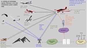
PS: that picture is unreadable, sorry.
You don’t get azimuth on Mode A/C/S emitters.
It is hard enough to spot a plane when the TCAS-1 is telling you roughly where it is…
I know not everyone likes Pilot Aware but I do get bugged when people write factually incorrect stuff about it.
From the literature……
How PilotAware detects and processes Mode-C.
PilotAware receives the Mode-C transponder messages directly using the integrated 1090 receiver. The PilotAware uses the altitude encoder data to work out the relative altitude to the host aircraft this data is then passed directly onto navigation applications.
Because Mode-C doesn’t contain a position, PilotAware uses signal processing algorithms that take the signal strength and rate of change of power to determine an approximate relative distance based on user configurable parameters. This relative distance is then passed onto navigation applications for display in what ever manor they choose. This may be a banner or a circle around the target aircraft.
PilotAware gives you the option to configure the sensitivity and filter out unnecessary aircraft.
I do understand the concerns over the total result of they system, and that if the 3rd party Transponder is out of range of any interrogation then it will not be visible.
But based on not having anything vs having some help, it’s very good.
vic wrote:
Did you install the TAS instrument – and why at all ? Seems to me not worth it when not typically flying in Airbus altitudes. A Flarm box is another case , a better idea I´d say. But I instead went for Pilotaware and ADS-B IN and OUT via Trig transponder. But then, I don´t know much about TAS boxes, you will just get traffic warnings with altitude shown, like S transponder altitudes on the tablet running Pilotaware. Vic
vic, while I like PAW (and I’ve got it as well) it uses the ground stations to pick up Mode-S and cannot work with Mode-C, while can do all those things independently.
It costs a lot, but it is worth it if you have the money.
The Mode A/C/S transponder is still by far the most ubiquitous “electronic visibility” device in GA.

