
Jan mentioned adding a VFR feature to the EuroGA autorouter…
Is that actually meaningful? (a serious question)
How do people plan and fly VFR nowadays?
If one reads the UK pilot chat sites, one gets the impression that 90% of people start up one particular Ipad app and jump into the plane, follow the magenta line, and it tells them if they are going to bust airspace. The other 10% keep saying it crashes, is too complicated, etc, but they get instantly beaten up by the residents  (actually that comment is only about 50% tongue in cheek; I was on the receiving end of the baseball bat many times)
Personally, VFR, I print off a page showing the route and a plog with the waypoints, load these into the panel mounted GPS, get weather, get notams, phone the destination (to check somebody hasn’t just dropped their nosewheel on the runway and closed it, etc) and fly the planned route, taking shortcuts with the assistance of a proper VFR map product which does not and probably never will exist in a panel mounted form (I use a tablet running converted versions of the “real printed” VFR charts, which I have for all of Europe).
10 years ago, UK, about 50% of VFR pilots (flying “seriously” i.e. 50nm+) would do the above, probably with Navbox. The other 50% were sure GPS was illegal and spent hours preparing laborious plogs with this

and said they really enjoyed doing that.
Today, I am sure most people use GPS but what sort of workflow do they use?
I don’t know if Jan’s question was really about VFR flight planning or merely about flight plan filing, which are two different – although related – things.
Achim is right. Getting into VFR flight planning would be a huge job. And no reason to do it because it would be hard to significantly improve upon products like Skydemon. It would take lots of resources and also years of debugging (just as in the case of Skydemon) to come up with a 99% reliable database.
As regards pilot workflows for VFR planning, I am sure it is hard to put private pilots into “categories”. There are just too many ways of doing it.
I would very much like to see Achim’s facility offering VFR FP filing (“only” would be fine).
As he said, IFR pilots often use VFR for short/simple trips. Often the route is just a DCT – or you can file it as DCT because nobody checks the filed route on VFR FPs anyway, and you avoid CAS enroute using whatever means you have.
Skydemon, PocketFMS and other tools will do it, but you have to pay for those. IIRC, SD is GBP 170 to buy and about 100/year thereafter, and it stops working if you stop paying so AFAIK none of the features are usable afterwards. Would I pay 100/year for VFR FP filing? Absolutely not. I already pay here there and everywhere to remain in aviation at the IFR level. It’s a long list of unavoidable stuff… $400 for the KLN94 database, GBP 150/year for the JAA IR revalidation, etc. I buy the Navbox update 1x or 2x a year. So I use free tools for VFR FP filing – EuroFPL or AFPEX.
And a VFR-only pilot could still use the facility, with the only difference being that he/she will likely be pasting in a route with more waypoints.
There may be too many different workflows but not as many as there are in IFR
What seemed nice to me is to have everything in a single tool. But if it is such lot of work, than I won’t be hoping too much.
To answer Peter’s question: up till now I have been able to resist using anything paid for – except hardware. That is to say
-) I plan the flight on paper charts, between known waypoints, mostly aerodromes and navaids
-) from the list of waypoints, an Excel sheet creates the PLOG with wind correction, giving estimates for headings and EET and fuel burn
-) if required, I file the flight plan through my CAA’s website, or sometimes by phone
For flying, I use self-written moving map software on a netbook. It shows the planned route vs. the effective route, along with navaids, aerodromes, and a few bits of airspace data that I managed to type in – I am still thinking on a way to import public domain airspace data, as is common among glider pilots.
I find it nice to know that every component I use is known to me inside and outside, that’s microlighters spirit. And I have found it all very reliable – except last Saturday, when I was punished for relying upon unproven hardware.
It works, usually, but it is quite a bit of hassle.
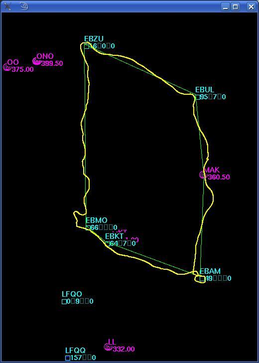
Example from my moving map software:
(I tried to drag and drop the image, as requested, but that seems not to work. Doubtlessly I am missing something.) – [FIXED – Peter]
(and to those who wonder who taught me to fly in a straight line: the goal of this flight was to diagnose a magnetic compass, it was found to be off by up to 60 degrees, and never less than 20…)
Last time i tried, a year ago, i realized i forgot how to use “it” … I’m also not good at calculating WCA’s and all that other stuff … I just fly where I want to go :-)
A good friend of mine is just finishing his PPL. In two years of flight training (took him that long becasue of business etc) NOBODY every showed him ANYTHIJNg about a) avionics, b) GPS (not even how to make a DCT), c) autopilots, d) modern computer/tablet base flight planning …
I find that completely ridiculous.
b) GPS (not even how to make a DCT), c) autopilots
Because none of the club training aircraft had a GPS nor a working autopilot?
I think Jan you are trying to drag an image displayed by a program (in this case an image displayed in a web browser) into the EuroGA edit window.
That won’t work, because most programs don’t support drag/drop of objects which they are displaying, out of themselves. But Windows Explorer does, and I think most “file manager” type programs should.
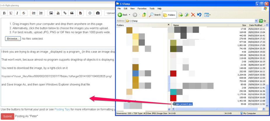
So, you need to download the image from the website, to your PC, by a right-click on it
and do Save Image As, and then open Windows Explorer showing that file
(depending on your browser config, it will probably end up under C:\Documents and Settings\USERNAME\My Documents\My Pictures although in my case it is in c:\temp)
and drag/drop the file from the Windows Explorer window to the EuroGA window
It’s a great facility and you can drag/drop a whole load of files like that in one movement.
The file(s) gets placed in your post at the current cursor position.
Sorry I had to blank out the other content of my c:\temp – too compromising 
Would I pay 100/year for VFR FP filing? Absolutely not.
True, but anyone who needs to file VFR flight plans also needs to plan his flight before that. And this means either a) having a program like Skydemon and pay the dosh or b) buying loads of (unavailable) paper charts and manually plan the flight on that (again, lots of dosh).
No free lunch.
Today, I am sure most people use GPS but what sort of workflow do they use
This is mine (often days before the flight)
On the day of the flight
I read good things about Achims tool, but for VFR would I use it – no. There are enough options and alternatives for me personally at the moment, so this would be no value add, even if it was the better tool. There are only so many ‘tools’ you can use.
True, but anyone who needs to file VFR flight plans also needs to plan his flight before that. And this means either a) having a program like Skydemon and pay the dosh or b) buying loads of (unavailable) paper charts and manually plan the flight on that (again, lots of dosh).
I agree with your drift, but the reality is that the vast majority of pilots never leave their own country. And the southern UK chart is about 15 quid. And you still have to buy it even if you fly with a tablet, in case the tablet packs up (gets a bit of sunlight on it )
I guess enough people feel the program offers worthwhile additional value, but how many IFR pilots buy these mainly-VFR apps?


