
achimha wrote:
A researcher in Sweden just published a paper examining our GFS based GRAMET versus a prototype using the Swedish national model in regards to how accurately it can predict low level clouds and the result was quite surprising: no significant improvement over GFS.
That is indeed surprising considering the much higher resolution of the Swedish national model.
I read the report and the study has a potentially significant problem. To determine the correctness of the forecast data, the forecast was not compared to actual observations but to the model data itself for the forecast time – in effect a “forecast” 0 hours in the future. This was done out of necessity as the ground observation network is sparse and the radiosounding network even more so and in any case observations are not done continually.
The author mentioned a smaller study she had done for selected locations and times where actual observations were available. In that case the Swedish national model indeed tended to be more accurate than GFS although the sample size was too small to draw any reliable conclusions.
This is discussed on page 26 of the thesis.
Just for the record, London – Bonn – London yesterday afternoon was utterly wrong (optimistic) again.
The depicted clear blue was actually freezing OVC SC all the way and low overcast and light rain on arrival.
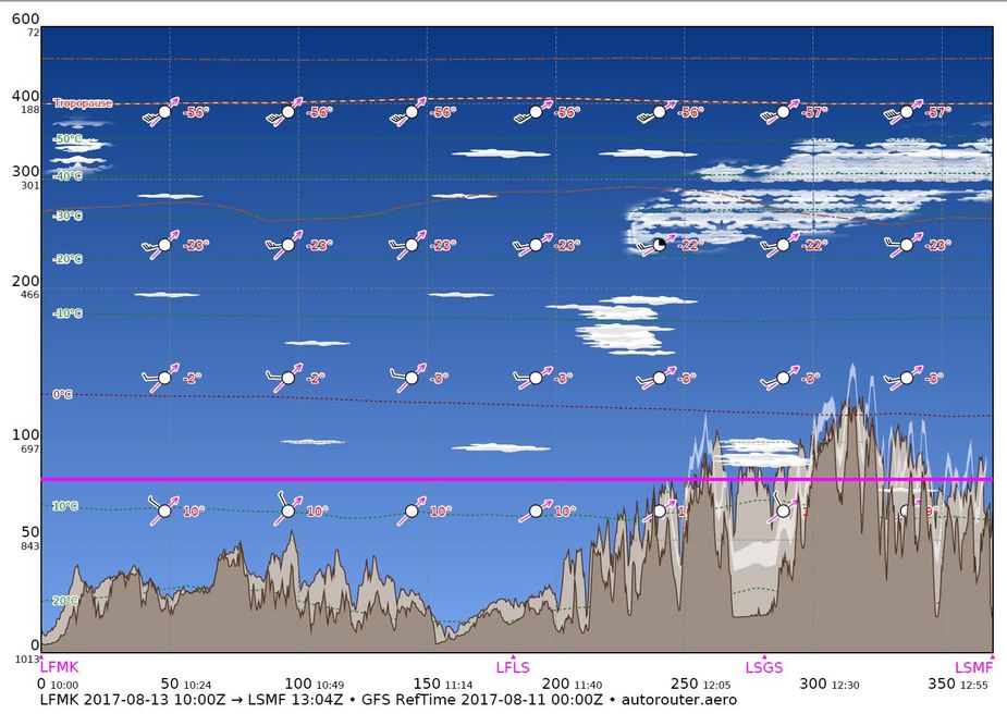
what do i need o expect over LSGS, for me it looks overcast ?
Thanks for help
Lucas
For cloud you have to use tafs and metars.
GRAMET, LI and TS
When I looked at this:
I looked at this:
and thought (and, indeed told my passengers) that it was going to be a lovely day.
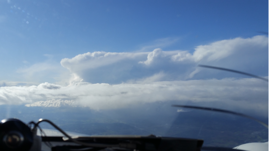
I was a bit surprised to see this when I got to the airport:
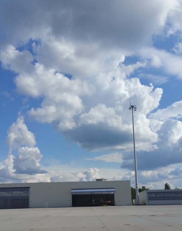
but didn’t think too much of it.
So I was quite surprised to be straight into some fairly nasty icing and turbulence in the climb.
Unfortunately, ADL wasn’t telling me much. Most annoyingly it had areas of strikes substantially displaced from areas of heavy precipitation, and my Stormscope mostly seemed to go with the strikes.
So, while I was in IMC, I just gave everything a wide berth and Munich Radar were able to help with some general advice (along the lines of avoiding the Leipzig area).
Eventually, after a fair bit of rain, ice and bumps, I popped out to see that I was surrounded by:
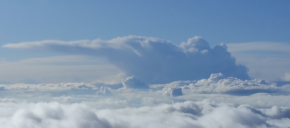


and many more.
My question is basically this.
If
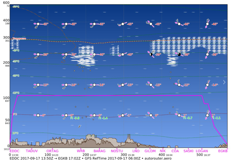
means the above, what does tomorrow’s:
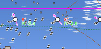
really mean?
It showed a good chance for convective activity and not much else. Exactly what you got. As to when and how much — that is beyond the ability of a wide area forecast system.
The extent of the buildups would have shown on a sat image right before the flight.
You could have performed that flight as VFR with that weather, right?
achimha wrote:
You could have performed that flight as VFR with that weather, right?
Absolutely not! I took those photos when i got the chance, but most of it was embedded in CU and SC.
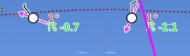
But what I am interested in is how numbers like 0.7 and 1.1 result in widespread active thunderstorms (more anvil like than most  ) when the index marks them as at the bottom end of unlikely?
My question is basically this.
If <> means the above, what does tomorrow’s: <> really mean?
It’s a lifted index, which is a single layer (surface to FL180) measure of the (in)stability. I think it’s a good measure of “showeriness”, but not of TS potential, for which CAPE is more useful (hint, hint). You can have a day with a highly negative LI where the showers never penetrate the high-teens, but are still very annoyingly widespread at the sort of levels you and I fly at. You can also have days like you observed, with marginal LI, when there aren’t very many showers around and the air in the teens is mostly clear, but where the convection happens it’s quite big.
This is why I raise the ticket about depiction of convective cloud (nudge, nudge, Achim) :)


