
I am not arguing that JMFDVFR does not have a way to go to catch up with the rest – my views are well known within Jeppesen. I do maintain though that it has the best charting and the integration of the Bottlang is excellent.
boscomantico wrote:
Terrain depiction sure is good in JMFDVFR… much better than SD or EVFR. GP’s terrain depiction is lousy.
Can you explain why JMFDVFR’s terrain depiction is so good? I’ve never seen it, and just curious what makes it so good? Is it the resolution or the actual way it shows it?
Why should they be paying DFS ? They produce their own airport charts and do not use DFS charts.
Yes, sorry, what I meant was that their price looks better (but only to people who fly to/in Germany) because DFS charge for their VFR charts but they come free with the Jepp product.
most flightplanning features missing
I thought you could put together a route? What can’t you do? A lack of user waypoints is very bad though.
Peter wrote:
A lack of user waypoints is very bad though.
You can create user waypoints within a route and they are stored with the route but not available outside the route. I wish Jeppesen would get their act together on this – the basis of a really great app is there but they need to put flesh on the bones. The team in Neu-Isenburg all seem very enthusiastic but progress is very slow. The danger is that the competition will get so far ahead that it will not be possible to catch up.
DP,
I have to admit it’s probably much a question of personal taste and not so much an objective comparison of the “quality” of the maps. But anyway:
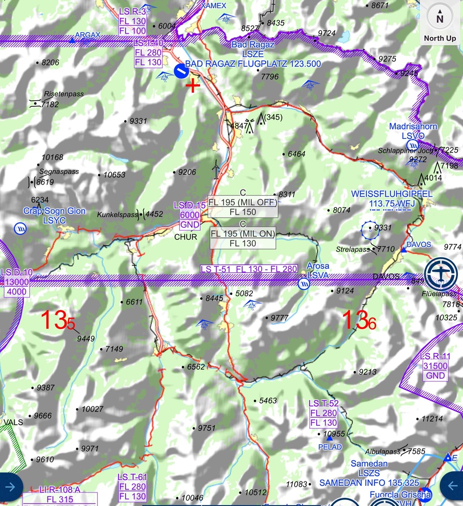
Jeppesen:
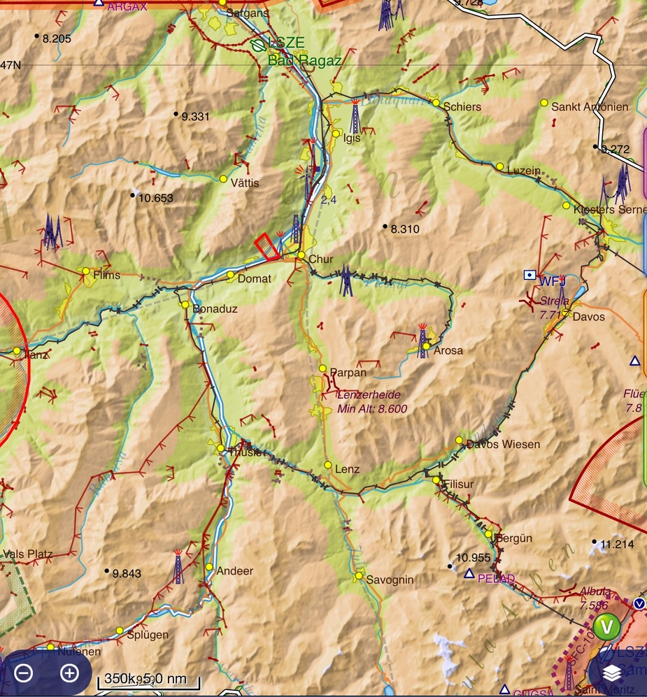
For comparison, Skydemon:
I think the Jepp style is very nice and detailed. Let’s you see very exactly where all the valleys, ridges and crests are. But as I said. In the end, it’s probably subjective.
What is a fact though is that Jeppesen has a nice number of spot elevation points, which gives you a very good idea of the height of the highest peaks in the area you are flying in. Compare with SD, where this number is quite insufficient.
Could you post a shot of the same snippet from EVFR, which I no longer have access to?
Peter,
re JMFDVFR and flightplannung features: plotting a route and producing a flight log is only flightplanning in the narrow sense. Flightplanning in the wider sense is including things like doing W&B, filing flightplans, etc., all of which is missing in JMFDVFR.
OK, but let’s face it, these things are easily done anyway. There must be 100 apps for w&b. I guess filing a VFR FP from an ad-hoc route is nice though. But what % of European VFR traffic crosses borders? 1%? Admittedly Spain and Greece need them for most flights.
On the map shots you posted above, the Jepp one is way better. The SD one has most of the relevant spot elevations missing.
Peter wrote:
On the map shots you posted above, the Jepp one is way better. The SD one has most of the relevant spot elevations missing.
I disagree: the Skydemon view has fewer spot elevations, but does have all the ones I would immediately care about, and most importantly it has the pass minimum altitudes (absolutely critical for flying in the valleys).
I would argue that the 5,082 spot elevation on the Lenzerheide pass in Jepp is quite misleading given that on other passes (Fluela, Albula) they give you the pass minimum altitude.
Also, Jepp is missing the cables!
No, they (both Jepp and SD) usually give you the pass elevation. Lenzerheide pass is a bit of a mystery here… SD doesn’t show the pass altitude for this one (which is about 5075 feet), but a “min.altitude” of 8600 feet, whereve that may come from.
boscomantico wrote:
Could you post a shot of the same snippet from EVFR, which I no longer have access to?
boscomantico wrote:
I have to admit it’s probably much a question of personal taste and not so much an objective comparison of the “quality” of the maps.
In EasyVFR we don’t show any spot elevation. But let me jump back in time bit first to explain. Back in the early days when PocketFMS ran on PocketPCs, we introduced a feature, that just like paper charts, showed terrain contours and noted the elevations on the contour rings. Functionally it was perfect, showing the contours of the terrain, and allowing you to see the real elevation just like a paper chart. But no one like the look of it, and most users didn’t use the feature.
Instead almost all users (including myself) just used the regular terrain shading. So as terrain got higher, it got darker, and you could tell from the terrain colour how high the ground was. It was very functional, and prettier than the contour lines. When EasyVFR came along, the contour lines feature wasn’t carried across as it was rarely used. I don’t think anyone missed it to be honest.
Then a few years ago, we replaced the elevation shading with lighting shading which shows the valleys in a prettier way (as in the Jepp and SD screenshots above…sorry I’ve forgotten the technical name for this type of shading). Now this introduces a problem. The terrain elevation shading is no longer particularly visible. So yes, you can see where the valleys are, but you’ve no idea how deep they are. How do you convey this to the pilot? We considered using spot elevations as Jepp & SD did above.
But take a moment and consider this. Imagine you were planning a VFR trip through that area (I know nothing much about this area, but since two screen shots have been posted, let’s use it). We get a good idea of where the valleys are. But how much altitude do you need to make it through those valleys? Which way is best? If there was an overcast cloud layer with perfect visibility underneath, could you make it through any of the valleys safely at 8000ft? Which ones? As I look at the chart, from the comfort of my sofa, with all the time in the world, I can’t really tell. I can of course take a guess, and by reading all the spot elevations, I can take an educated guess, but I can’t be sure. But 8000ft might not be too difficult giving there are areas where the peaks only go up around that. What about 6000ft? Is there a way through there at 6000ft? To me this is truly impossible to tell from either of the screenshots above.
The spot elevations simply don’t convey that information. That’s why we discounted the use of spot elevations to solve this problem.
Anyway, before I go any further this is the same area in EasyVFR.
![]()
As you can see it suffers from the same problem. I think the terrain elevation colouring comes through a bit more, but it’s still not possible to tell if we can do the flight at 8000ft or at 6000ft. So what we did to solve this problem was allow the relative terrain colouring to be used not just in flight, but also in planning. With just two taps and one slide, you can quickly set or change a planning altitude and see what sort of terrain clearance you have.
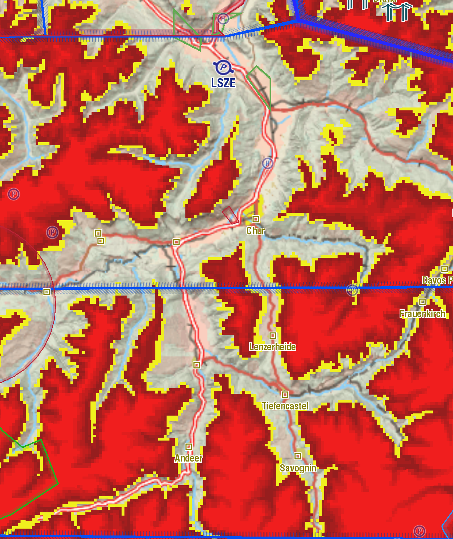
For example, I just set the planned altitude to 6,120 (yea sorry…I should have picked a more rounded number!). It’s now instantly clear where we can safely go and where we can’t at 6000ft. I don’t need to spend any time reading a mass of spot elevations, nor wondering if I have all the right ones, to know where I can safely go. This shows me where I can go, in ways the spot elevations can never do. It gets around the problem of the light shading for elevation removing the clarity of terrain elevation shading.
Hopefully you can follow all that, and I haven’t confused you!
Colm


