
I did once buy the Skyguide book.
You can now get the data electronically - on CD. Not that anyone outside of FOCA (NAA) still has working CD drives...
Not sure whether they now take credit cards
Having attended the presentation, one gets a free 6 month subscription.
The current coverage is
Austria
France
Germany
Switzerland
UK
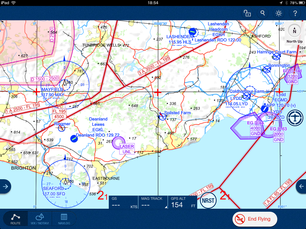
I mentioned the main features in a previous thread so here is just a comparison of the mapping, compared with the old Jepp VFR/GPS charts.
Firstly this is not JeppFD – it’s a different app and it took me a while to realise that. JeppFD does not accept the login/pwd I have. JeppFD is the IFR app.
Secondly there is something funny going on with the displayed database sizes. When I first installed the app and checked for available maps, it showed about 1GB for each of the five! I have 3.5GB space on the Ipad so I downloaded just the UK one. But after the UK one was downloaded (which did take a long time, corresponding OK to ~1GB) the others showed up as much smaller – of the order of 5-20MB per country. So I downloaded the lot.
The Settings app on the Ipad (Usage) now shows 1.5GB used up by JeppFD which looks roughly right, corresponding also to the downloaded maps getting unzipped and expanded in-situ by some large factor.
Why the app showed as requiring a 5GB total download needed for the current coverage, I don’t know, and it’s clearly wrong.
Here are some maps:
Ipad: (full size file)
VFR/GPS chart (electronic version) (full size file)
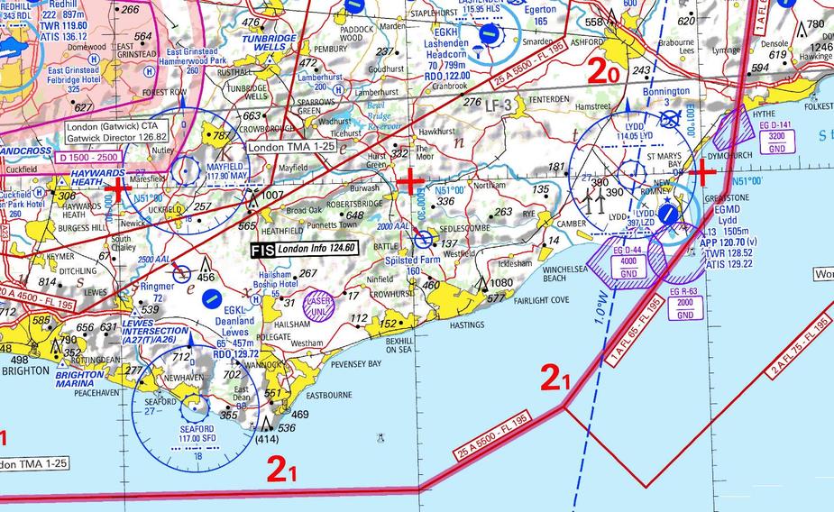
There may be resizing artefacts in the images visible above, but you can see that there are fewer place names for example. Bexhill and Hastings are not named no matter how much you zoom in, though the Brighton Marina VRP does appear if you zoom in a long way. Whether this bothers anybody is another matter, but for example Lydd ATC habitually ask departing traffic to report at Rye, so JeppFD-VFR is not a replacement for the printed chart as it stands.
There doesn’t appear to be much config anywhere. For example you cannot config what features appear on the map, beyond a simple set of on/off switches for
nature/wildlife area
military route
airspace e/f
lat/long grid
navaids/v-awys
and I had all of them enabled.
So it is a very simple prog, which is probably a good thing for many users. But a replacement for the VFR/GPS charts? No way; not with so much detail removed.
Oddly enough the “military route on/off” setting doesn’t seem to do anything for France, where the obvious low level mil flying routes e.g.
are shown the whole time and never decluttered (which is probably right, but then why have that setting?).
I noticed this (too many town names missing) also with Skydemon.
However, to be honest, I wasn’t aware that the difference between Jepp paper and Jepp MFDVFR was that significant. Your comparison also shows how poor the terrain is rendered in MFDVFR.
I agree: no suitable replacement for classic VFR navigation.
Re the military thing…that LF-R149G is not a route, but an airspace.  The toggle probably only switches routes depicted as lines (wherever that may exist).
Rumour has it that thBeNeLux void will be filled inJanuary. I had the impressionthat the terrain was pretty much the same as the paper charts
One thing which suprised me is that the map legend doesn’t appear anywhere in the program.
It exists as a separate PDF.
The filename is Mobile_FliteDeck_VFR_US_Legend.pdf and maybe the USA is where Jepp started this project. But the USA has free VFR charts (the “sectionals”) which have been available electronically for years – as GeoTIFF for example, usable instantly under Oziexplorer.
The vector database of the Jepp app has two main advantages over “image” charts:
The way Jepp have done it, most of #1 is wasted, party because there is little or no useful config, and partly because there isn’t much detail to start with. Only Class E/F CAS is removable and much of Europe doesn’t have any of that, so really this is so similar to just running the VFR/GPS raster chart under say Oziexplorer, or under the old Flitemap app. Except of course neither of these runs on an Ipad….
Does Jepp FD VFR have the same representation as when it was primarily a paper chart? I wasn’t sure if it had been overhauled to be more aligned with each countries local charts, or if there was a standard across all regions.
You sum it up well by saying simple, and that’s fine if that’s what you want or it is on a 2nd iPad, but with a lack of NOTAM’s and other useful features its not something I’d use right now.
That said there is one good VFR planning product I know of, which to be honest seems to be getting a bit bloated with new features and customisations, and I remarked on it’s Facebook page that it’s in danger of being more configurable and slower to set up than a GNS430 !. Whenever a new idea is posted sometimes1/3 like it, 1/3 dislike it and other 1/3 want it made even more complicated and configurable, and it frustrates me now. One day I think I am going to get fed up with too many options and maybe Jepp FD VFR will become my saviour.
JeppView MFDVFR started as a European project. It is very much a work in progress. I know some of the development team and they are all pilots and open to suggestion. Unfortunately, things seem to move so slowly within that corporate giant.
Does Jepp FD VFR have the same representation as when it was primarily a paper chart?
It clearly has less – see my examples.
Whether this matters is a matter of how the user uses it. The airports, navaids, VRPs and CAS are all there, and what else do you need to fly? That’s not really tongue in cheek; I think it is true if your Plan B is VOR/DME and nothing lower. I could not fly, with avoidance of complex CAS shapes, with a sudden transition to map+stopwatch if you paid me for it – in any real scenario – and neither could most pilots, frankly.
Whether aviation maps should show names of towns and villages, is a good topic… ATC are entitled to ask you to report at a published VRP. They are not entitled (but frequently do) to ask you to report at some village. I think this is a serious omission; not for “locals” but for somebody flying far out and perhaps dealing with ATC which can barely speak English.
Clearly for map+stopwatch nav the maps aren’t going to be any good. But nobody is going to be using these maps for that – it is a moving map GPS.
If OTOH somebody printed off pieces of the map (not sure how you could do it non-painfully, from map tiles captured on the Ipad using screenshots) to give to somebody to navigate “traditionally”, that won’t work.
but with a lack of NOTAM’s
JeppFD-VFR does have notams, tafs and metars.
That said there is one good VFR planning product I know of, which to be honest seems to be getting a bit bloated with new features and customisations, and I remarked on it’s Facebook page that it’s in danger of being more configurable and slower to set up than a GNS430 !.
My guess is that Skydemon are working hard to get ahead and stay ahead, as far as they possibly can, by covering every angle and every taste, before other products (like JeppFD-VFR) get better and start eating SD’s lunch. It’s easy to pack in more features (I read of new requests daily in their support sites; only today somebody asked for integration with some satphone product) but a view that a product is too complex will always be hugely unpopular.
I know some of the development team and they are all pilots and open to suggestion.
You know where to send them
I will drop a hint
Update:
The part that takes up the 1GB of space is the terrain, and even though one country has been downloaded it will download the whole terrain database. Once this has been downloaded, all the subsequent coverage downloads are much smaller.
So the initial display showing ~1GB for each of the five countries is really incorrect, though the reality becomes apparent as soon as you have downloaded the first country.
Regards pricing:
The price for Europe after the trial has finished is 349.00€ for the year’s service and 129.00€ for a 28 day service (not sure what that is). For just the UK the year’s service is 199.00€ and the 28 day service is 89.00€.


