Peter’s asking for trip reports, so here goes:
My trips are strictly VFR and pretty tame compared with the achievements of many of you. However, they do cover some terrain and illustrate the point made in the thread about pilot numbers: flying has never been easier, in the US and also in Europe, at least partly thanks to the marvellous hand held devices we enjoy today.
This is a round trip out of Prescott KPRC, Arizona for 2 weeks in January 2018 taking in a visit to the Rockies, a trade show in Las Vegas, and an excursion into beautiful Oregon. And, Prescott being 100 miles from the Grand Canyon, a crossing of the Great Chasm as well.
I’m going to split this report into chapters, as I write them. This is Chapter 1 – To Durango!

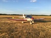
The aircraft is a 172SP, and on these winter days and with one (sometimes two) on board, she springs from Prescott’s mile high runway.
There’s no finer place for VFR flying than Prescott. At least 300 flyable days each year with no controlled airspace (apart from it’s own friendly class ‘D’) for 100+ miles, it is within a day’s round trip of some of the world’s greatest wonders: The Canyon (of course), Monument Valley, Meteor Crater, Hoover Dam, the Colorado river and of course sin city itself, Las Vegas. And plenty more.
But before departure, a formality forms part of my routine: a call to Flight Serivice (1-800-wx-brief) to file a VFR FPL and “request a standard briefing”. I always file out here, partly because when I’m on my own usually no-one else knows I’m even flying today, far less when and where. After all, I didn’t decide myself until watching the weather channel last night! It is January, after all. And the briefing is a chance to discuss the outlook with a like minded individual, as the briefers always seem to be. I’ve already studied the Prog Charts on Foreflight along with Tafs and Metars along my route, but often the briefer can suppliment the forcast with pireps and other observations that help my decision making.
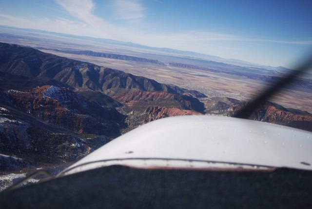
My route today takes me North East, past glorious Sedona, the ‘aircraft carrier’, (No time to visit the brand new airport restaurant today), Flagstaff, Arizona, past the San Fransisco mountains and on into Shiprock, New Mexico in the four corners area before landing at Durango, Colorado. All in one afternoon.
On the horizon is the Shiprock, “like a sailing ship of old standing out to sea”.
The briefer had already pointed to the weather in the Rockies “we have to say this” he says, “VFR flight not recommended in areas of mountain obscuration”. Well that’s right, but I know the terrain and the various bolt holes to the South and West, like Farmington, New Mexico. And today Durango is in the clear, despite the vast mountain range behind it being completely invisible. I don’t want to sound cavalier about this though – I’ve never had a weather scare out here in more than 30 years flying, partly because of the excellent forcasting and partly because I’m very, very timid about this stuff.
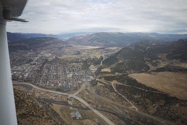
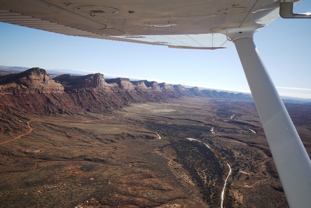
This is Durango, with the San Juan range of the Rockies rising to 14,000’ within 30 miles, in the direction of this picture.
Today I’m landing at Animas Air Park KOOC, which is closer to town than the Durango airport , since I don’t need a rental car for my overnight stop and know from bitter experience that it’s expensive to get a ride there. The friendly FBO refuels my plane and calls a cab for the short ride into town and my hotel, down by the train station. And the train is the main reason people come to Durango.
The Silverton and Durango Railway runs 55 miles through the spectacular Animas River gorge, entirely worked by enormous coal fired steam trains running on a narrow 3’ gauge. And it owes it’s origin to the UK, because the founder got the idea for narrow gauge while visiting the Ffestinog Railway in Wales.
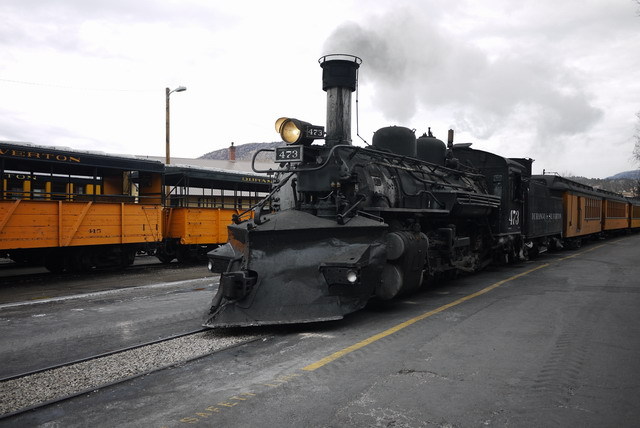
I’m here in time to see the evening train come in, but will have to forgo the chance to ride myself because the next Pacific system is closing in, and I need to be in Vegas on Monday. Never mind – I’ve been here before!
Next time: to Vegas
Nice! Looking forward to the forthcoming chapters!
Aveling wrote:
My route today takes me North East, past glorious Sedona, the ‘aircraft carrier’, (No time to visit the brand new airport restaurant today)
It is wonderful, if a bit expensive. Not your standard airport food, or close. If you stay at the hotel adjacent to the airport its a very good choice, especially given that people drive up there from town just for the restaurant. We had one meal a day there on recent trip to Sedona, it was nice to walk over for breakfast.
Looking forward to the next episode!
Great part of the planet, Zion is also in your one day radius.
Chapter 2 – To Vegas
Next morning, low cloud prevails and the Durango airport is giving IFR. Time for a stroll around town! Far to the west, the next Pacific system is charging toward the California coast and promises to bring a lot of moisture into the SW. This has been an unusual winter, because in spite of the atrocious weather in the Eastern US with it’s ‘weather bombs’ and other outrages, the West has been warm and dry. There’s no snow in Durango, something that’s very unusual at this time of year. At least I don’t have to be worried about the plane being iced, or snowed, up.
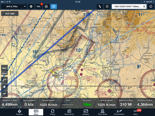
Late morning, the cloud lifts and breaks up. Perfect timing! Here’s today’s route:
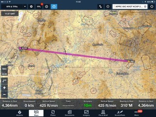
Here’s a last look at Animas air park’s 5000’ runway, elev. 6684’. In the winter, with one POB and full fuel, this altitude offers no surprises for the Cessna SP. In the summer, with 100 deg F, it might be a little different… Altitude is always a concern out here. To get through the mountains between here and Grand Junction, Colorado involves climbing to 14,000’ for a few minutes, which is quite OK if a little asthmatic for the Cessna, but for the pilot and passengers it might be another matter. And just around the corner from here is Telluride, elev. 9070’, where the trees get smaller only very slowly and I would not go in summer, period.
I’ve been blessed with good altitude tolerance and perhaps being based at 5000’ helps with acclimatisation, but a recent trip with a friend through the Rockies at Monarch pass led to some discomfort on his part and a smart descent over the ridge, a reminder that we can never take this country, or ourselves, for granted. Always monitor those vital signs and in my case, work out the time in England. If I can’t do that, it’s time to get more oxygen!
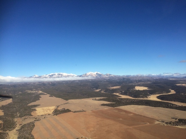
Looking back at the Rockies, we can see the remnants of the morning’s cloud burning off. Ahead, it’s beautiful VFR, despite flight service warning of possible IFR conditions ahead in Utah. Not long after departure, I can see the steam rising from the power plant at Page, Arizona 150 miles to the SW and I know as long as I can see that, (as I will for the next 250 miles), I have an escape route to good VMC. This is the thing about flying in Arizona – you don’t really need a map, because the landmarks, like the 10,000’ Navajo Mountain just south of my track, are visible from one side of the state to the other!
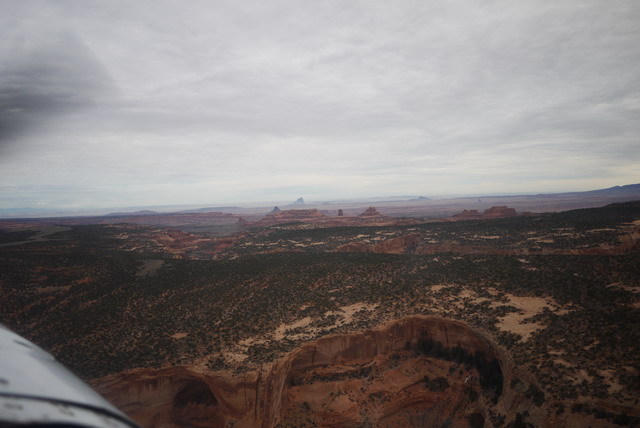
Now something different creeps across my line of flight. The outcrops of Comb Ridge run N-S from one horizon to the other, a razor toothed fault line capped by pearly white limestone. In this country, the mechanism of the Earth is laid bare for geologists to understand and aviators to play with. What a magic carpet the 172 truly is!
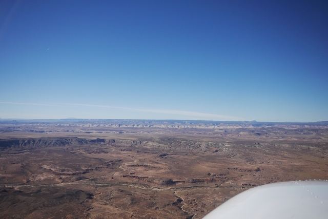
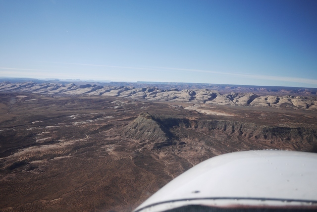

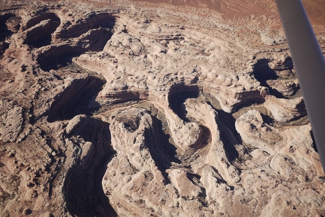
Beyond Comb Ridge, the limestone plateau has been carved into incredible loops and meanders by desert streams, all running down to the mighty Colorado river and the far away Pacific Ocean. Every one of these intricate canyons is a haven for life, the streams lined with green vegetation. What an extraordinary world this is!
Before long, the Colorado itself creeps into view. Swelled now by the Glen Canyon dam down at Page into the vast outline of Lake Powell, it’s said the shoreline stretches for thousand of miles. Before the dam opened in 1966, the canyons here were in many ways as spectacular as the Grand Canyon itself. Now, they are the playground of thousands on houseboat owners, the tiny white dots on the water far below. (This land is a ‘National Recreation Area’ and pilots are ‘requested’ to fly at least 2000’ above and away from the surface. As a visitor here, I take these rules seriously. Some of the areas’ like the ‘National Sea Shore’ that lines much of the Pacific coast, have the force of law and Rangers have binoculars!)
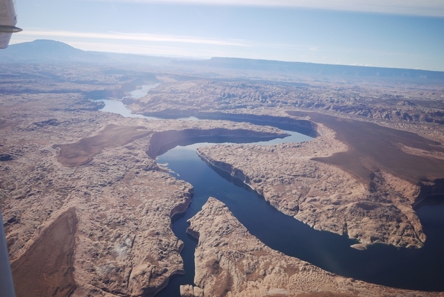
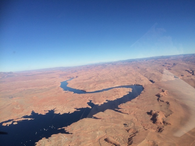
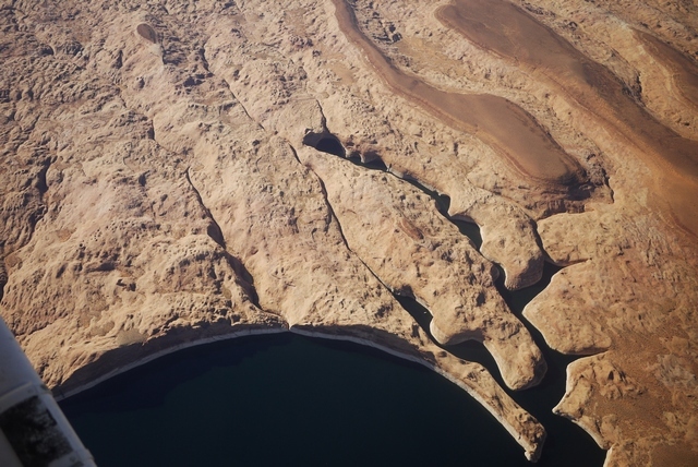
Countless inlets provide spectacular mooring sites. Note the white line along the water – this shows the high water mark, and has been getting ever taller as the SW suffers a prolonged drought lasting many years now. Not to mention the ever increasing water use from the new housing that encroaches ever further into these vast desert lands. When I first flew here, the deserts at night were an unending sea of inky black darkness. Now, everywhere that you look are the twinkling fireflies of habitation, even in the remotest corners.
.
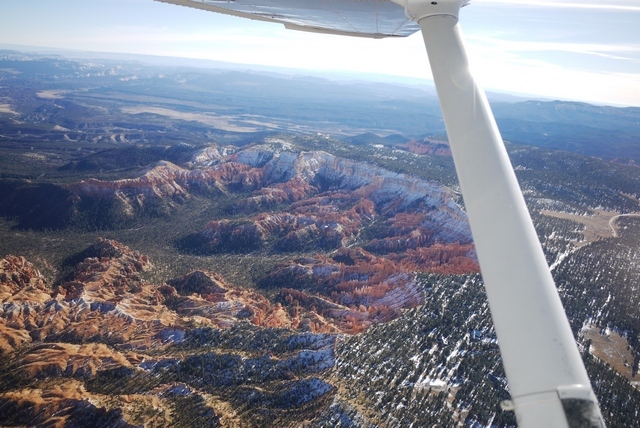
Leaving the Colorado behind, the surface begins a steady climb from 4000’ at the lake, and so do we. Ahead are the spectacular pinnacles of Bryce Canyon and it’s very convenient airport KBCE, one of the most conveniently located in a National Park, at almost 8000’ elev. (Most parks, like Zion mentioned above, involve a fair bit of ground transportation after landing. Grand Canyon is amongst the least convenient, but the doesn’t stop me from visiting the El Tovar hotel at the rim if for lunch if I have the requisite 3-4 Hrs! At Bryce, you can land and hop on a tour bus).
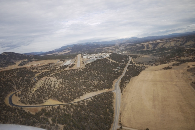
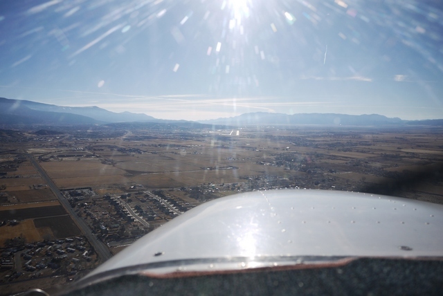
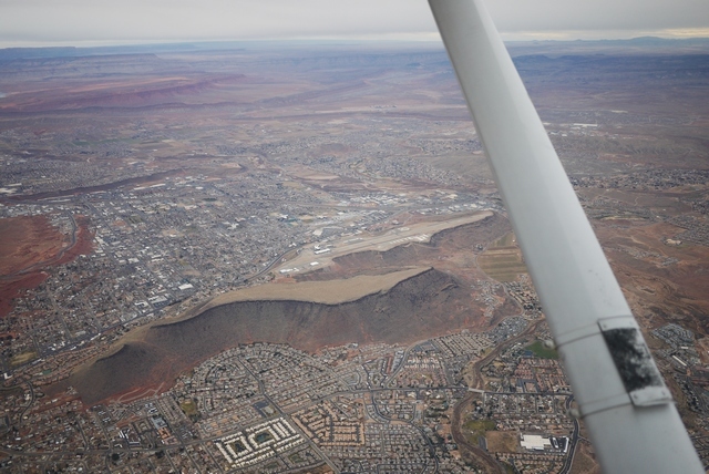
Now at last the final obstacle today, the bottom end of the Warsatch Range, begins to fill the Cessna’s wonderful panoramic wrap-around windscreen. (This one difference between the R, S and SP models and earlier 172’s means everything to me). Beyond, and 6000’ below, is my destination for today – cosy downtown Cedar City KCDC, Utah.
Crossing the ridge line at 11,500’ I begin a lazy descent into the valley beyond and hear another aircraft – the first I’ve heard all day – also going to Cedar City from close to my position, though much lower. We exchange distances on the radio and he’s much faster than me so never a factor, but it’s good to know he’s there. The system of CTAF (Common Traffic Advisory Frequency) works so very very well at these non-towered airports, so much better than our own over-prescriptive arrangements often do.
The forecast IFR conditions are not completely obvious, but actually 100 mi to the N of here, at Salt Lake, it’s well and truly socked in with the combination of atmospheric aerosols and cold temps forming a blanket dense enough to put off CAT, let alone little 172’s! But here, it’s gorgeous – for now. That Pacific storm is still coming on like an express train, and one reason for landing Cedar City is that it’s on the I-15 freeway, just 3 Hrs from Vegas KLAS. So my meeting tomorrow is in the bag, especially since the FBO has their own rental car. But I’m hoping I won’t need it.
Next time: What happens in Vegas…
Beautiful pictures and a great write-up, keep it coming!
What happens in Vegas … Gets published on here!
Next morning starts overcast and clear, but not so in Vegas, just 150 mi away to the SW. That Pacific storm is on onshore now, and reaching out beyond the Sierra Nevada mountains into the ‘basin and range’ province that makes up much of Nevada. The TAF for my destination this morning, my old stomping ground of KVGT, North Las Vegas (known locally as ‘Northtown’) is quite OK with 4000’ cloudbase and moderate vis. affecting the last part of my route. And I have plenty of bolt-holes along the way should things not be to my taste. Another great thing about VFR in the US is that virtually any airport is diversion material, without any hang-ups with PPR, landing fees, customs, etc., and so the temptation to press on regardless is greatly reduced.
Here’s the ramp at Cedar City, with the lovely little town nestling up against the mountains. Cedar City = Utah = no slot machines! Bliss.
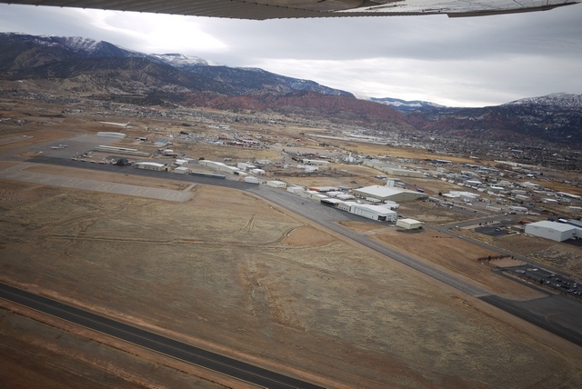
Note how not busy this ramp is. OK, it’s January, and there was a bit of a discussion about moving my plane from outside the FBO to the parking area “in case it got busy” but that wasn’t necessary in the event. A note about brakes here: FBO’s like to move aircraft around the ramp, so never, ever leave the parking brake on. Partly because you don’t want to come back to a puddle of hydraulic fluid on the carpet, and partly because Cessna brakes are so puny the they might not notice when towing, but still twist up the caliper assembly.
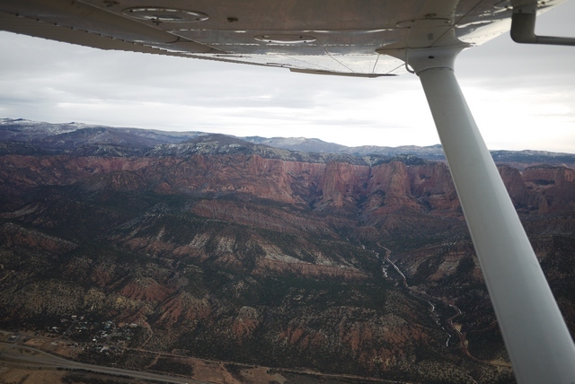
Here’s the way ahead, looking perfectly clear and just visible through the mountains the red rocks of Saint George KSGU, Utah, one of my favourite stop over locations in all America. On the left is Zion, one of the most fabulously scenic National Parks on the whole continent, abd below the I-15 freeway which I’ll be following all the way to Vegas. (IFR!)

And a peek into Zion’s NW corner:
By now I’m in touch with LA Center for flight following, since there will be traffic approaching Vegas and the vis is already declining. It’s perfectly possible to creep into Northtown underneath the Vegas class ‘B’, but on this approach from the N the airspace is controlled by the ever helpful Nellis AFB who never fail to clear a route a) into class B and b) more or less direct Northtown. This is not always the case in the S end of the valley, where things are much busier and clearance into the Bravo may be slow coming. I always pick up flight following when going to a populated area because it simplifies handovers and ensures that you get passed to the correct approach and tower frequencies on arrival.
There is a drawback to flight following though: it can be difficult to cancel a VFR flight plan on arrival. Departing Cedar City, I’ve opened my flight plan with Cedar City Radio, an outlet of the FSS (Flight Service Station) who administer the plans and asked for an onward frequency for flight following in this area, which they look up for me. But once on flight following, it can be difficult to leave, or even switch to box 2, to cancel the plan on arrival for fear of missing something. So you have to be very disciplined about closing on the ground after landing, because it’s so, so easy to get distracted while taxying, parking and shutting down.
As a note, I always give my cellphone number in the FPL, not my home base or worse, number in England. I carry a $20 Walmart PAYG phone for this purpose, because nobody in America will call you back if you give them an international number – they don’t know how. The number is there in case I forget to cancel, because the first thing FSS do if you go (30 mins) overdue is to call the number. Then they call the airport, or if unattended, the Sheriff to go have a look. Only after that do they start talking helicopters. A bit different to NZ, where VFR FPLs are mandatory and fines are automatic for failing to cancel. Ouch!
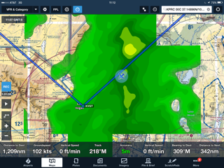
Here’s the chart:
And Saint George. Note the ‘old’ airport at centre and the ‘new’ airport just behind the strut at top. The old airport, another ‘aircraft carrier’, was right in the town and great fun. One morning I filed to go there, only to be told by the briefer “Oh no you’re not”. It turned out that was the very morning of opening for the new airport, and I was the third arrival, possibly the first light aircraft, and certainly the first Brit to land there! Initially the location was a pain, so far from town, but the hotels geared up and offer free shuttle services, a half-hour drive, to the Hilton or the Wyndham. The Wyndham is very nice and the lady who drives the bus is a retiree from California who once owned a B-25, used in many movies!
One night long ago in the hotel at the bottom of the mesa at the old airport, I turned up an article in the local paper about a Dinosaur trackway that had just been discovered close to town. “Take the so- and -so ranch road, and turn left at the water tank” it said. Next morning I found the place and found myself walking a dry gulch, in the floor of which were dozens of quite sizeable footprints. There was something quite eerie about following these tracks in this silent and remote place, following a modern stream bed that had been a stream then as well, countless millions of years ago. The closest that you can ever get to this lost world, IMHO. The trackway is long gone, but much of this material can be found in the city’s brand new Dinosaur Museum – well worth a visit.
The northern extremity of Lake Mead, formed by the damming of the Colorado River by the Hoover Dam, comes into view through the worsening vis.

Nellis have cleared me “own navigation” into the Class B direct to Northtown and the Vegas valley creeps into view beyond the ridgeline. There’s quite a bit of rain now and Foreflight’s radar mapping shows I’m headed straight into it. But it also shows the Metar for VGT is still VFR with an adequate cloudbase. Obviously this relies on a 3G/4G connection, but my experience is that iPad will get data much of the time when in range (10-20 mi) of habitations. During a long cross country, even in remote country, it’s always possible to get updates at intervals and it really makes a big difference to VFR flying because you can avoid or work around weather, or simply land and wait it out.
A note: for this to work, you really need a bona fide AT&T sim card in the iPad. Other brands, even if working on AT&T, suffer from all kinds of throttling. This includes 3’s otherwise excellent ‘feel at home’ feature, which I use for all UK calls with perfect results, but not for data. So my first port of call on arriving in the US is an AT&T store, where you can buy a sim for cash, avoiding the ‘foreign credit card’ issue which is still prevalent. In my experience no sim bought from ebay etc. offers the same connectivity as a genuine AT&T sim.
On my left, passing Nellis, is Frenchman Mountain looming in the murk (actually 10 mi). You have to watch this one, because it moves! Specifically, it’s moved 70 mi in 50 million years and if you’d been stuck in the hold at McCarran for that long you’d have seen it creeping up on you. I’m not making this up! (Well, the hold at McCarran bit perhaps.)
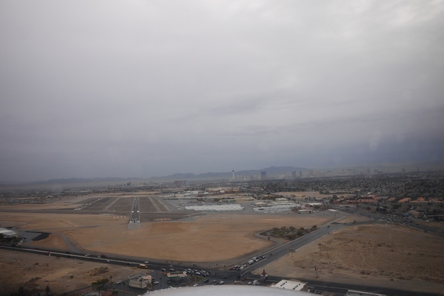
Soon the valley opens out and Northtown (centre) comes into view, with the Las Vegas strip behind. This approach from the North is very leisurely, but some of the published VFR routes can involve very rapid descents after being handed over by Las Vegas (in the class B) to VGT tower at the last possible moment. The published route from Lake Mead involves local landmarks like the ‘Showboat’ (now the ‘El Cortez’) and the Spaghetti Bowl freeway intersection. In the days before Foreflight, some of this could be challenging, being dumped out at 4500’ 3mi from an airport at 2000’ and expected to join base or something. How VFR flying has changed thanks to iPad.
Finally, final for 12R, having crossed the 12L approach which is also being flown by a faster twin who lands ahead of me. Northtown has a bit of a reputation as a runway incursion hot spot (I nearly wrote ‘capital of the world’, but those days are gone. Apparently). Note the crossing 30 runway, just beyond the threshold, which is also simultaneously in use. My landing is uneventful (and familiar – I’ve been flying here for quite a few years) but quite recently on final I was asked “are you LAHSO equipped?” which I didn’t know the answer to – some sort of automatic braking? so I replied “affirm I can land short” which seemed to be good enough. LAHSO – Land and Hold Short – was basically invented at Northtown after some fairly shocking roll-out collisions involving intersecting runways.
Taxying in, I’m aware of the empty transient ramp, traditionally occupied by lines of parked aircraft on this pre-show day of the Consumer Electronics Show (CES), supposedly the biggest consumer electronics trade show in the world and reason for my annual pilgrimage to Las Vegas. I’m so surprised at being able to park in the front row that I have to mentally note that essential chore – close the flight plan – before closing down. (Controllers in the US won’t close flight plans for you automatically, or even on request, and while you can sometimes reach FSS frequencies on the ground that doesn’t work at VGT, so you have to make to call on your cellphone). In the days before cellphones (that worked) it really was a nightmare and several times I got close to the wire.
Nowadays, landing at a quiet or unattended field, I always call up FSS in the air to close ‘field in sight’. I tried that in UK once, only to get bawled out by some agressive ATC, back in the days when VFR FPL’s even mattered. Here’s the ramp, actually some days later, showing hardly anyone else parked in the meantime.

Well that’s it for a few days, all flying done, as I hunker down for the 15 miles of aisles in this vast show, jostling with 200,000 other delegates from all over the world. Even, rarely, other Brits. Just as well, as the storm arrives. No more aviation for me – or so I think.
That evening about 7,000 of us trudge over to the new Aria auditorium to hear the opening keynote, presented by Intel CEO Brian Krzanich. Brian spends the first 10 minutes of his presentation apologising for the latest security flaws, the cure for which is only going to affect the performance of every computer everywhere “only a little”. Apparently.
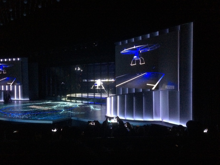
And then Brian gets into the business of the evening – drones. Amongst a medley of stage acts (That have something to do with consumer electronics, or not), he introduces an indoor drone show. These drones, 110 of them, are Intel branded and feature proprietary indoor non-gps location sensing, flying a 5 min routine that comes out into the audience. It’s quite surprising and impressive. The nearest thing I’ve seen to the daily sunset departure of a million bats from Carlsbad Natural Caverns in New Mexico, where the cave mouth has been made into an auditorium and the bats spiral up through the audience.
Come to think about it, Brian does have a bit of ways to go. However he plunges on, and reaches his piece de resistance – the Volocopter. Now Intel branded, this multicopter human capable drone is going to revolutionise inner city travel, and presumably Intel’s fortunes in a chip market that seems to drifting away from computers toward cellphones. The Volocopter (I established later) has a duration of 30 mins, running about 100Kw, with a typical mission time of 10 mins and a 2 Hr recharge time. It’s main cost advantage over conventional aircraft is, apparently, the absence of any need for routine maintenance or ‘tear down annual’ according to one of the staffers. Indeed the only maintenance would be occasional replacement of the 18 model airplane propellers that drive it and annual battery swap outs.
To prove the point, Brian unveiled the full size Volocopter on stage in what he said was the first ever indoor demonstration of one of the devices. In the picture you can see it’s heavily roped down, and the audience is protected from any shrapnel that might arise by heavy transparent curtains. Nevertheless, he did fly it, if not in it. Apparently he has done that as well. So the future of consumer electronics is in: aviation! Hmmm…
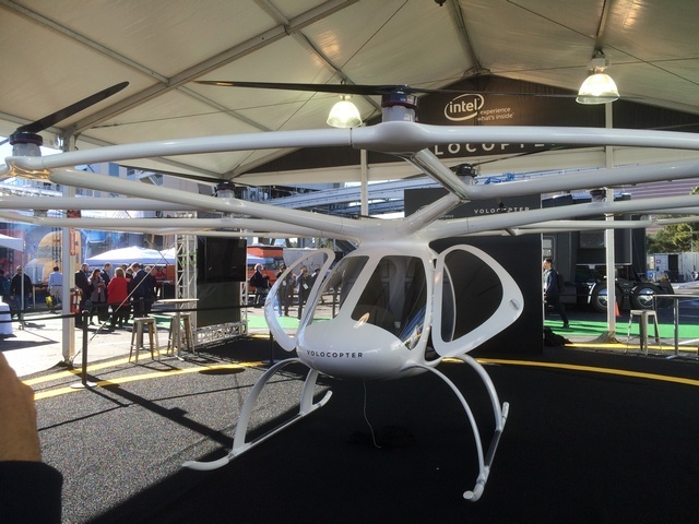
(This is an actual picture. The real Volocopter is stage centre. The image top right is a projection screen. Note the strong ropes and heavy curtains).
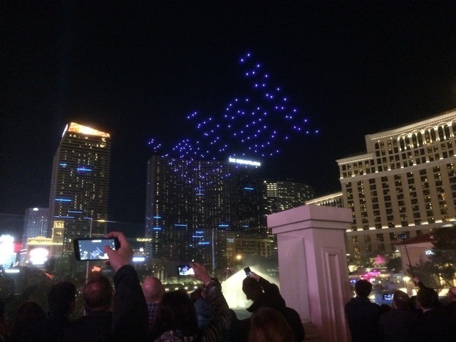
Later in the week, Intel ran an outdoor drone show, this time with 300 drones. The repertoire is pre-programmed, but the recovery is interesting featuring batches of drones forming a loose gaggle back to the stage and behaving more spontaneously, or so it appeared. (2nd pic)
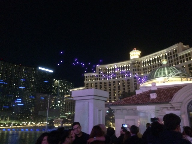
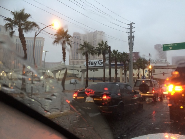
But tonight, the weather really closes in. In the next 24 Hrs, it rains continuously. My timing, with the aircraft safely parked, could not be more fortuitous. The drone shows are called off – drones are not (yet) waterproof. And Las Vegas drowns, in rain and also in traffic – the worst I’ve ever seen. Roll on Friday, when the skies are brighter and horizons clear. For now, it’s a 15 mile slog around the show.
Next time: TGIF!
Great report ! I love following you on your journey.
We can’t wait the following reports !
Prescott seems ideally located to tour the SouthWest VFR, which I am interested in someday. Where did you rent your 172 ?
I checked via Airnav.com and I got this :

Ouch ! As expensive as in France !
I heard of PlusOne at San Diego as a much better deal.
Great reports and really like the geological-cultural twist to them.
Super reports, Aveling. It’s a whole new world out there… Many thanks for posting them.
I remember a lot of the scenic places from my travels in the 1980s, but never saw them from the air.