Noe wrote:
Other than larger aircraft. It seems to make more sense to have light aircraft relate to larger aircraft than to cars. Especially when ATC is common, no?Every map with a latitude scale ends up having a NM scale (1 minute of latitude → 1 nm) so probably every map also ends up having a scale in nm.
Sure, all that is true but US light aircraft pilots are not particularly focused on ATC, particularly not those who fly Experimental Category aircraft to avoid regulation that doesn’t relate to their real world needs and activity.
The FAA was the force that put knots in US certified light aircraft, and yes, FAA certification standards for light aircraft were changed to align large and light certified aircraft for the benefit of FAA ATC; this being in the pre-GPS era when nautical miles had practical significance for long distance flight in large aircraft. So if there were any resentment over the use of knots (I don’t think it’s actually high on many people’s list) it would be toward the FAA.
This is one of many other (more significant) FAA issues that motivated people into Experimental Category where they can do more of what they choose. Which brings us back to Vans… giving more people with cash to spend what they actually want to buy, at a price they can afford. That’s generally how business works and Vans has proven to be pretty good at their business 
Silvaire wrote:
It’s just that nautical miles and knots add no value to light aircraft operations
I beg to differ. Every aeronautical chart will use nautical miles. Every GPS will use nautical miles and knots. Etc. etc.
Airborne_Again wrote:
Every aeronautical chart will use nautical miles. Every GPS will use nautical miles and knots.
My flight planning is done in statute mph if the plane is in statute miles. The scale of the chart is whatever scale is on the ruler I might use for that planning (or the marks on the string on the wall), my ruler has both nautical and statute and I don’t generally fly directly north-south. I set GPS (Foreflight) to match the aircraft’s ASI calibration, i.e. in statute miles when the ASI is in statute miles.
ATC wants airspeed not ground speed so when its necessary to report speed I mentally divide indicated airspeed by 1.15. That actually doesn’t happen often in practice – they have my speed on radar.
I do VFR flight planing using the size of my finger but it works only on the half mil chart and me !
On pannel instrumentation you could all scale it from 0 to 100% on max values and refer to POH numbers whatever their units are?
You can still do live calculations as long as you know the conversion factors for your aircraft, but that will make most PPL/ATPL exams aircraft dependent, not everybody will agree with this, but private owners seems already know their aircraft in terms of 0% to 100%…
Did we not have a thread on units not that long ago?
I still think that in an ideal world we would completely do away with non-metric units. Statute mile, nautical mile, what’s the use? 90% of the world’s population never use any of these. So following the “real world needs” argument of Silvaire, these units are really completely pointless and only used in certain corners of the world where modernity hasn’t fully arrived yet. Best switch all instruments and charts to km and km/h, then you can basically plan VFR flights with normal road maps save for the airspace boundaries…
MedEwok wrote:
then you can basically plan VFR flights with normal road maps save for the airspace boundaries
I do a lot of initial planning for VFR flights using Google Maps or Earth on line. Very useful for visualizing terrain, what the airport looks like etc in places where I’ve never been before. Stuff like this might result (note that speed units are knots to match the ASI  )
)
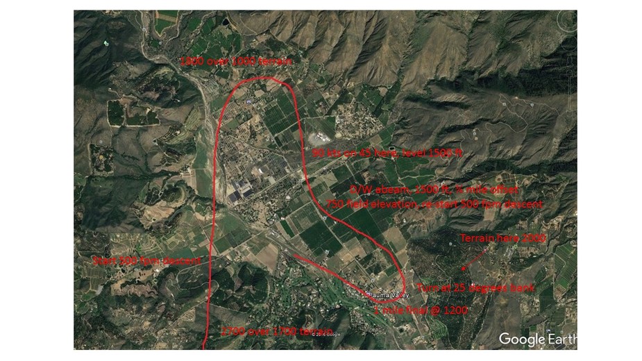
I do a lot of initial planning for VFR flights using Google Maps or Earth on line. Very useful for visualizing terrain, what the airport looks like etc in places where I’ve never been before. Stuff like this might result[…]
Same here. I also use Google Earth for flight planning. For intra-German VFR flights the website fl95.de is very useful, it even has an “export to Google Earth” function for the flight path.
Obviously my comment above was somewhat tongue in cheek. In the US or UK miles are in everyday use and this will remain so for the foreseeable future. People tend to hold units they are used to very dear.
We are very familiar with this in medicine. Blood pressure in mmHg for example: a completely non-standard unit that is terrible to convert, but everyone is completely used to it. Blood glucose in mg/dl… at least this one is derived from two SI units, but the “correct” measurement would be in mmol/l, which only the former communist states use (and some university hospitals like mine, which always leads to confusion: what? My blood sugar is 5? I’m dying!). Incidentally Russia, which also uses mmol/l does also use meters and km/h in aviation…Silvaire wrote:
My flight planning is done in statute mph if the plane is in statute miles. The scale of the chart is whatever scale is on the ruler I might use for that planning (or the marks on the string on the wall), my ruler has both nautical and statute and I don’t generally fly directly north-south. I set GPS (Foreflight) to match the aircraft’s ASI calibration, i.e. in statute miles when the ASI is in statute miles.
So you’ve created your own personal air navigation infrastructure. (You’ve hinted at that in many previous posts, too.) Very well, but most people would find it most convenient to use the existing one. And then they will want to use knots and NM.
I am personally very much in favour of international standardisation of all kinds of units, but I’ve come to accept that the aviation world is simply is so large and interconnected that it is unreasonable to expect a change. Even ICAO gave up on SI-units after having had them as the primary set of units for many years.
But my alternative to knots and NM would certainly not be mph and statute miles but km/h and km.
When ATC tell me “speed 180 to 4DME” they mean 180kts, and the DME is reading in NM
MedEwok wrote:
Incidentally Russia, which also uses mmol/l does also use meters and km/h in aviation…
According to their AIP they do use feet/flight levels as the primary unit for altitudes with metres as a secondary unit.