I use Air Navigation Pro on my Mac to look at charts on screen. It has its uses like that.
The general interface however, in my opinion, remains largely opaque and full of cludges (I have an IT degree…some things I just can’t work out how to do on Air Nav Pro.)
I am currently planning a flight to the Netherlands so I just purchased the Netherlands VFR charts on Air Nav Pro…on second attempt…I think I may have had to pay twice. The AirNavPro software says it downloaded the chart and shows it in my list of “installed products” within the software with a little green circle next to it. Great.
However, when I go to normal chart view all my UK charts appear and as I pan to the east the charts disappear. The Netherlands chart doesn’t appear at all. Nothing. Blank screen space. 25 pounds spent for nothing.
Moreover, AirNavPro tells me that the Dutch airspace data is a free download. Excellent! I try to download that data in precisely the same way as the Netherlands chart and the software tells me that I can’t download it because that data “needs to be managed through your AirNavPro account”. I have such an account. I have no idea what the message means. Why is there any restriction on a registered user (me) downloading what the product says is a free download??
For the above reasons and others, I won’t let AirNavPro near my aircraft. It has to stay on the ground at my home on a Mac for very occasional use. It doesn’t ever accompany me flying. In my opinion the user interface is about as unintuitive as could possibly be the case. Some years ago I thought this software looked like hobbyist-written software. My opinion has changed very little. It’s such a pity, because flying with geo-referenced charts would be a blessing.
Hurrmph!
Howard
Hey Howard, I am actually a fan of AirNav pro, mainly because I am a nightmare with paper charts. I believe you also need to activate the chart in your active chart list. I use it on all y VFR navs, working on my IR now so most of my flying has been under the hood these days and ther I agree it is of absolutely no use. The interface has also changed lately, I liked the older version better tbh, ther is also the altitude feature which somehow they have linked to a QNH setting (God knows how) which makes it all wrong now…
As LFHNflightstudent wrote, make sure the map is active. You may also want to choose the order in which the maps overlay eachother.
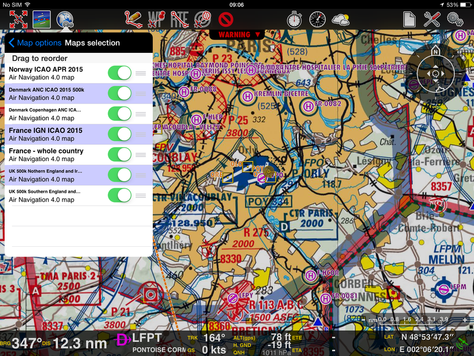
Ah yes, as well as downloading the charts, in an entirely different part of the software (also different from your screenshot because the Mac and PC versions are different) one has to also make the downloaded chart “active” if one wants to see it. There is however no message on the download screen that advises that you have to do that, and no message on the blank chart screen that one has to make the chart active in order to view it and there are no menu items that make charts active! Instead one has to go to the a tab at the side of the screen marked Map, click on a further flag called Maps and then there is a box to make a chart active. What an absolute joke. The user interface needs a complete re-write.
Skydemon seems like it was written on a different planet to AirNavPro…one populated by humans! :D
Ok, so I have created an aircraft profile on AirNavPro but can I add fuel to it? No! The system tells me that no aircraft is assigned to the flight. Great. no clues as to how to assign the aircraft I have created to the flight I want to plan.
This is why I don’t use this piece of crappy software. It wastes my time whenever I use it and the author refuses to compensate me! :D
I usually swear at this point. Lol
It also quits without prompting the user to save his work. I want to sue the author.  He didn’t do any user testing. That was an implied term of me agreeing to pay him money for my use of his software!
Some years ago I worked for ANP. Back then i helped the developer (a Swiss guy) get the contracts for the approach charts and I tried to improve it visually. We made good money with it then, and since I got a percentage on the sales, that was pretty cool for a while.
I left because I could never convince the owner about a more modern look and many other things. For example I hated the fake DG (that showed a GPS track…) and some more, and in the end I just ran away … Too bad, because for some time the app really had a lot of potential.
TODAY, I dont see how ANP could ever compete with SkyDemon or the new Garmin app. The idea to use scanned charts in this way just became completely old fashioned and unflexible.
I too started using ANP after a recommendation by a friend of the “Swiss guy”.
This was before Easy VFR and SD and I concur that ANP has been left way behind. In fact I recently deleted the app from my iphone because I am unlikely to ever use it again.
The Android version of ANP has always been a disaster, bought it but never used it for real.
Air Nav Pro was the first Moving Map software I used back in 2012 but the programmers were seriously incompetent. In those days, if they released an Update to the APP Store you HAD to download it before you could use the program – iTunes had that restriction. On 3 subsequent releases they programmed a bug which meant the software didn’t know which maps were installed and the only way to have it realise what maps were installed would be to reinstall them. When users installed the update and noted their (paid for) maps were no longer available, they released a bug fix, only to introduce the same bug on the next update. And the next update after that bug fix.
I was in Budapest when an update came through so I had to install it and hey, my maps were gone. So I had to pay to download the charts via data roaming and the programmers, when I complained about it, said: “Not our problem, we tell you downloading maps can incur roaming fees”. They totally missed the point that three times in a row they caused major hassles.
Either way, my recommendation – there are plenty of options out there so go and chose another software. Sky-Map, for example (my personal favourite) or Sky Demon. You don"t need to put up with the **** that these guys put me through….