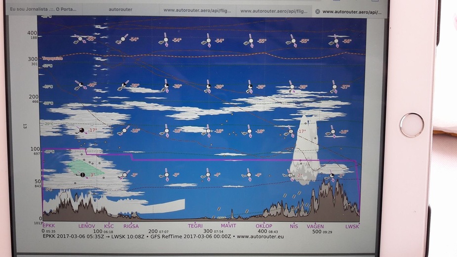
From TEGRI to OKLOP, yes but otherwise no…..
No I would not (especially not the EPKK to Rigsa stretch). I have flown between Nis and LWSK and might consider that leg depending on weather trends.
The basic thing here is that the autorouter gramet is mostly fiction when it comes to cloud depiction. It uses GFS data and that simply doesn’t work most of the time for showing clouds.
Stuff like frontal wx, where TS is likely, is depicted as TCUs/CBs, but that’s blindingly obvious anyway. Away from fronts, the clouds are mostly meaningless….
Especially for low level cloud which is the biggest VFR restrictor.
The best way to plan a VFR flight is tafs and metars along the route, perhaps with MSLP as a longer-range go/no-go decider. And a hard policy to turn back if it is not VMC, etc.
Forget the gramet for VFR. It’s not much good for IFR either, IME.
I find GRAMET pretty good if you know and understand its limitations.
Cloud indications are very approximate, and it can miss low level cloud entirely. When low level cloud is shown it is usually present. Layers of cloud are usually there when depicted, but can be +-5000 ft. Convective tops are good to about 10k feet, except on days where the tropopause is limiting – then they seem to be very good.
The freezing layer is usually pretty accurate, and mid level winds are a good indication.
I use it for mid level cloud forecasts and a quick reference on the freezing layer, but I like to see front/MSLP charts as well.
Personally, I wouldn’t fly it in that direction (departure over anything but completely trivial terrain with significant cloud) – but I would fly it the other way quite happily on the assumption that a diversion is very likely.
Peter is right though – you need a lot more than just this for VFR planning. IFR is a lot easier.
jwoolard wrote:
Peter is right though – you need a lot more than just this for VFR planning. IFR is a lot easier.
so..would you fly it IFR?
Frankly, I don’t know. I never used nor even heard of a GRAMET before. It wasn’t included in my met lessons at ground school as far as I remember.
We mainly use METARs, TAF and GAFOR for VFR flight weather planning at my aeroclub.
We really need to know much more.
Is the pilot flying VFR capable of flying in IMC if necessary? Would a pop-up IFR clearance likely be granted? What is the climb performance of the aircraft? Is it cleared for icing?
If we are talking about a VFR pilot who is likely to lose control if he inadvertently entered cloud, or in a wheezy old C150, then the answer is no. But I took the “you” in the thread title literally, and I definitely would, in my aircraft as it is equipped.
MedEwok wrote:
It wasn’t included in my met lessons at ground school as far as I remember.
Because it is not an official and verified source for aviaiton weather. I also only ever heard about it on this forum… At work we have something vaguely similar produced by our service provider PPS. And the german weather service DWD has a similar product which is accessible through “www.flugwetter.de” (requires a paid subscription – most flying clubs and schools have one or will give you the password of a friend of a friend).
So personally I would not base my decision whether to fly or not, VFR or IFR, on GRAMET. If any of my “official” weather sources would show me a similar picture I would not fly with a light plane with no anti-ice and weather radar in these conditions, neither VFR nor IFR.