From here
Peter wrote:
it is hard to work out what would be suitable fly-by waypoint names to put into the Autorouter. The Autorouter map can be zoomed to show aviation waypoints (it is no longer a google map) but one needs the IR or radar overlay on it
Your favourite flight planning app on a tablet should be able to display this. In Skydemon, I would activate “Weather” > “Rainfall” and then find a suitable waypoint to feed to Autorouter.
I am not sure what my favourite flight planning app might be. I plan VFR from the charts, and IFR using an autorouting tool.
The wx images I get from the internet, mostly via a private site which gets them, strips off the adverts etc and serves the bare images. The #1 difficulty is that all these wx sites use different projections so georeferencing them would be nontrivial.
The most useful wx chart for IFR route planning would be the IR image, not “rainfall” radar, because a radar image can show a huge amount of bad stuff which has tops at say FL100 and is thus easily overflown in any IFR touring aircraft. A radar image which combines sferics would be better e.g.
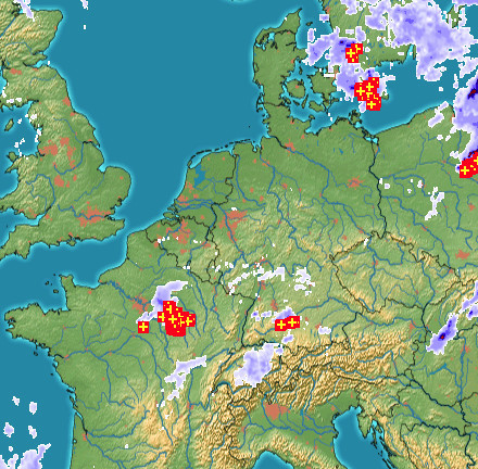
because lightning implies high cloud tops, but the best single image would be the IR (EUMETSAT has the commercial monopoly on the European image, sadly) although I use that in combination with the radar image to pick up cases where you have high cloud (e.g. FL300) with probably nothing underneath.
Since you stated “no PC available”, I left out possible web based solutions. Otherwise, I would have suggested skyvector.com, and activating “Satellite IR4” under “Layers” > “Weather” on top of the chart. Actually, looking at the site on my mobile phone it still works decently. Merely by clicking on the map, it will show you the closest waypoints and navaids. Or you can switch the map layer to IFR (“World Lo/Hi”) and use some of those waypoints and routes.
I went to skyvector.com with my phone.
It doesn’t GPS-locate and starts with a map tile in the western USA. Scrolling over to Europe… it is still of no use because the most I can zoom in is this
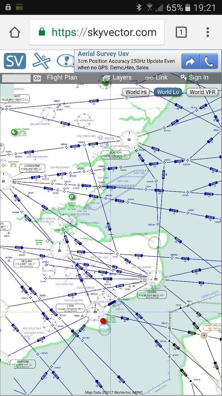
which is way too small to see anything on a phone. This is in Chrome. In FF it just crashes the browser.
I wonder if there is some other way to do this?
The Golze app would do this for you.
How?
The Golze App can be used free of charge via a non-Iridium (Wifi, LTE) internet connection. You can enter a flightplan and download the weather for your route (infrared, radar, sferics, winds, temperatures…) that will then be displayed on a map. This is not a full-blown flight planning app, however.
tschnell wrote:
The Golze App can be used free of charge via a non-Iridium (Wifi, LTE) internet connection. You can enter a flightplan and download the weather for your route (infrared, radar, sferics, winds, temperatures…) that will then be displayed on a map. This is not a full-blown flight planning app, however.
You would still need a DWD subscription.
What I have found would be most useful for this purpose would be something like the skyvector airway+navaid+airport map with selectable wx radar, sferics and IR overlays.
Then one could modify the route developed in the Autorouter to avoid the bad wx areas, by selecting some fly-by waypoints and re-routing through them.
Of course the best way to do this would be a user interface inside the Autorouter website itself, with rubber-banding of the route  That website already has a map very much like skyvector. But one could solve most of these issues by inserting just 1 or 2 fly-by waypoints.
You can do that in GP or Foreflight or Skydemon as suggested. In some of them manipulating the flightplan directly which can be filed and others having to go back to autorouter.