Garmin has to code the approach procedure to provide the LNAV+V
I thought it was Jepp who provided the database, and their +V "glideslope" was just a copy of what is on their plates as the continuous descent line.
Do you have a few examples of approaches,
I don't have a GNS/GTN box so will leave that to others to say what is actually in theirs.
I can certainly look at various plates, and even the ones for my base (EGKA) show the continuous descent line.
Re the Sandel SA4550...
Its data sheet suggests that it does not replace the KI256.
It is certified as a primary AI in loads of high-end-GA stuff, but they have not emulated the pitch+roll pickup coils (essentially a curved LVDT) which the KI256 contains.
The SG102 AHRS gyro can give you an "emergency AI" on the SN3500 EHSI. This requires a $1000 software key as well.
Peter,
I emailed you the GNS530W simulation for EGKA. Jeppesen provides the database under contract from Garmin, and provides the raw data to Garmin who then adds or modifies it as they desire and returns the finished product to Jeppesen for distribution. Garmin is responsible for the data. The data on the approach plate doesn't indicate whether or not Garmin added +V. You can't examine the approach plate and determine if it will have +V coded in the database, but normally you can make an educated guess from the approach plate. For a technical reason, Garmin will not code the +V on the approach plate if the final approach segment is 7.0 NM or longer.
Here it is
BTW I just uploaded your pic to imgur.com.
From NCYankee:
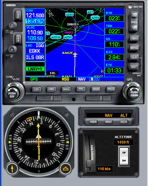
I ran the trainer for GNS530W, loaded approach for EKGA, selected RIPIL as the IAF, set trainer altitude to 1500 MSL, speed to 110 Knots, activated approach. As long as EGNOS is providing adequate integrity, this is what you should get.
Regarding redundancy and GPS... I find myself wondering whether in a solar storm, all the airliners dropping out of the sky due to lost navigation might turn out to be a relatively minor concern.
Probably we'd see the storm coming so the airliners could be grounded before the effects of the storm hit and from an aviation perspective the concerns would be more economic than loss-of-life. There could be real issues with the electricity grids failing, so VOR/NDBs could be shut down anyhow. Some suggest that it could take years to get the grids back online again due to the lead time for large transformers. Lots of services that depend on GPS would also fail - which I understand includes ATMs. How would the internet stand up? I don't know, but I doubt Amazon couriers could find their way around without GPS.
With all that going on in the background, aviation shutting down would be the least of our concerns.
Must have hit me in a cheery mood.
I am just now jumping into this discussion after having flown the GNSS/GPS approach at Lille (LFQQ) runway 08 approach in a Cirrus with Perspective glass last week. I actually filmed the approach, see the URL/link:
(the approach into Lille starts around 4 minutes 20 seconds).
I did get the +V added to the LNAV, which is advisory, so I would need to doublecheck the altitudes along the descend. The "glideslope" diamond-shaped glideslope-indicator on the PFD shows just as with the ILS. The behavior is the same and I can fly it to the runway.
You can download the free trainer from the Garmin website at http://www8.garmin.com/support/download_details.jsp?id=3532
After you have installed it, email me directly for any questions.
The nice thing about the G1000 with the integrated GFC700 autopilot, it will fly an LPV better than an ILS. This is because it integrates the roll steering lateral control with the vertical for the GNSS approach, so it is wind corrected to the runway at all times. The autopilot flies the ILS using the traditional lateral control scheme based on CDI deflection which means it can S turn with the best of them on final if one encounters strong cross winds at altitude that diminish with altitude as well as change directions. I flew back to back an ILS and a LPV at my airport. They both have the same minimums, 200 and 1/2, and they follow the exact same path. The conditions were with a strong crosswind at the PFAF (over 30 Kts) and much diminished closer to the runway. The ILS started to S turn at about 500 feet above the runway as it first drifted off center and then tried to regain it. I took over manually before the DH. We then flew the LPV, and it was a work or art. The wind correction angle was continuously changed on the descent and the needle was glued to the center. It was VFR, so I let the autopilot continue below the DH, but I took over manually at 10 to 20 feet to land, still in a slight crab, but tracking dead on the runway center line.
The vertical path is similar to an ILS, but there are some improvements in the LPV. The ILS is generally set at 3 degrees +/- .7 degrees FSD (Full scale Deflection) and because of physics is always angular, thus extremely sensitive near the DH and closer to the pavement. The LPV is angular and the FSD is .25 times the angle, or +/- .75 degrees for a 3 degree slope. But when approximately .6 NM to the pavement, the FSD becomes fixed at +/- 15 meters. Beyond approximately 6 NM, the FSD is also fixed at +/- 150 meters. For the LNAV/VNAV, the FSD is the same, but it becomes fixed when the FSD is at +/- 45 meters when close to the pavement. The +V follows the LNAV/VNAV FSD rules.
Most who have flown the GNSS vertical guidance note that it is easier to fly. Here in the US, I haven't flown an ILS in anger for at least 4 years. I much prefer the RNAV (GPS) and with over 3000 LPV procedures verses just over 1200 ILS procedures, the LPV is rapidly outnumbering the ILS 3 to 1. The ILS also involves tuning the ILS, identifying the localizer, switching the CDI source on the procedure and switching back for the missed approach, so there are more opportunities for error. Also distance and time to the threshold is always available for display on the GNSS procedure whereas with the ground based approaches, they depend on a nearby DME, possibly separately channeled and rarely located near the approach runway end.
I have to say that my KFC225 will fly an ILS just as well as the above LPV description - when it's servos haven't gone for a smoke 
It was a degree or two off track when it was driven from the KN72 lateral output, but now it's driven from the FCS output of the SN3500 EHSI and it is spot on, needles centred all the way down.
LPV is the way to go but here in Europe I wouldn't like to bet on the % of equipped planes. I think any survey here will come up with a fairly high % but that's because of the way this forum was initially promoted
It would cost me a lot of money. KLN94, KMD550 out, and probably the most long-term-sensible route would be a GTN650+GTN750. And remove the two KX1x5A radios, or maybe leave one in place, with a "ground switch" which connects it directly to the battery. That is roughly in the region of 30k. I wonder if I could do the design work myself... it would be a total rewire but in some ways it would be a simplification, because a lot of the interfaces would be via ARINC429.