What does this actually mean? It looks like you could be OCAS by flying through some canyons? Was somebody smoking something?
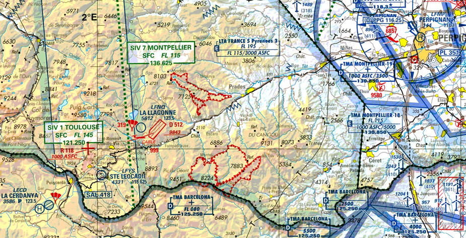
The wider picture is that I want to fly LFMP-LECD VFR.
The higher peaks in some places are below FL80, no? so not really valley flying.
There do seem to be some space where indeed you have no way of being outside that class D (other by flying above, or by flying a boring machine), but it might be a small enough area that they didn’t care too much. I would probably have done it differently myself, but this could be though of a more extreme version of a high mast going from the surface into low controlled airspace, you have to fly around it
What I was getting at is that specifying the airspace as say “1000ft AGL and above” would have been more normal and would have prevented bizzare interpretations (such as my deliberately provocative one  ) which might kill somebody trying to do it in poor vis.
There are a number of ATZs in the UK that you can fly beneath, or at least you could in pre SERA days.
AFAIU according to ICAO standards a control area can’t have a lower limit closer to terrain than 700 ft.
You want to see a case were somebody was smoking something?
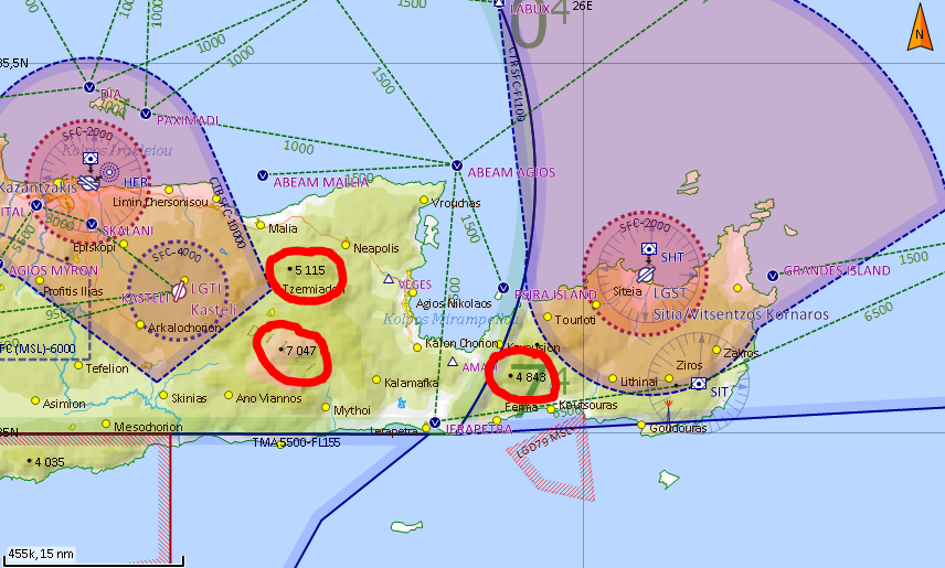
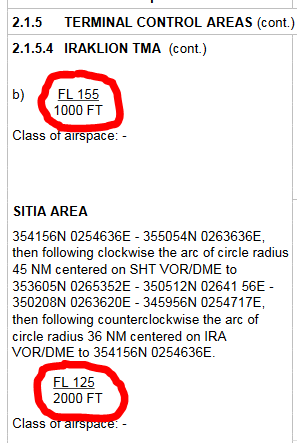
On the west you have Iraklion TMA and on the east you have Iraklion Sitia TMA.
The highest peak in Iraklion TMA is at 8058 feet (not visible, but there are more at 7047 feet and 5115 feet) and the highest peak in Iraklion Sitia TMA is at 4848 feet.
Iraklion TMA starts at 1000 feet AMSL and Iraklion Sitia TMA starts at 2000 feet AMSL.
In the AIP it doesn’t state AMSL or GND, but it has to be AMSL since Iraklion South TMA starts at 5500 feet and it doesn’t make sense putting something at 5500 feet GND over mountainous terrain. SkyDemon also depicts the altitudes as AMSL and they get their data from Eurocontrol.
So here we have TMAs starting under the ground
Now this is all pointless since in Greece you always talk to ATC. There have even been cases there ATC tried to control helis at 500 feet under the TMA.