
Hmmm… I would never use SD for obstacle clearance either. My Ipad2 loses a fix readily in my TB20, and shuts down in any sunlight. These things are good toys…. they work on a good day which in VFR is most of the time.
I would use an official “printed” VFR chart, showing the spot elevations properly, running as a moving map, driven from a rooftop mounted antenna.
But while such products do exist, they are of a marginal appeal since the “synthetic map” products have taken over the market. And the mapdata is a problem. Probably the neatest is the Jepp FD-VFR (I had one on trial for 6 months) but that is over €300/year to keep updated, and their coverage is still limited. The charts on that are synthetic but come closest to decent VFR charts.
If I wanted a good solution for say an engine failure above cloud, above mountains, I would get some kind of SV product running on my tablet. Maybe another thread…
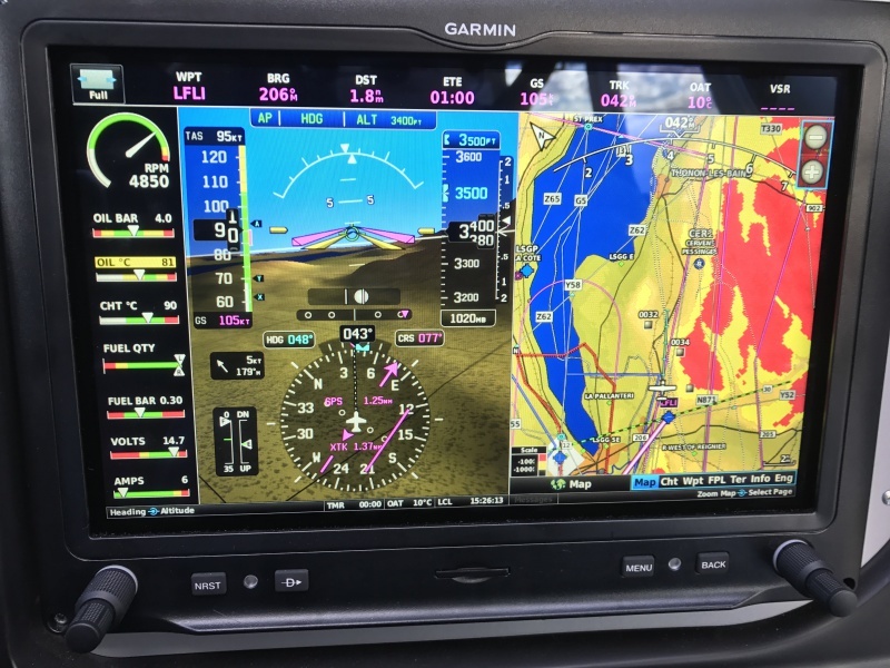
This a Garmin G3X taken last Sunday in the same general area.
Simon
Peter wrote:
and might have chosen to penetrate that specifically below the 0C. And I think the “6500” figure on the French SIA chart was the final hole in the cheese.
I think this kind of speculation is better left to journalists and less reputable internet forums. Furthermore, the unsubstantiated criticism of the BEA vs the UK AAIB is totally uncalled for. I am sure the AAIB invest in investigations proportionately with the size of the accident everywhere in the world. Let them do their jobs.
Edit: especially with the very limited means of investigation in GA accidents, specifically the lack of a flight data recorder on most aircraft
AnthonyQ wrote:
is the stupidity of refusing to use an iPad running SD or similar with a clear view of your track and a forward looking profile showing terrain…
It is difficult not to agree with this. A VFR pilot should use every available means at his disposal to navigate. SD or similar is of tremendous help. Good charts is of course also of very good help, but is more or less useless without planning, when things start to happen fast and not as expected – without hours of studying the chart up front. IMO, SD or similar is more of a “tactical” thing, but is not really a substitute for a good VFR chart in the planning phase (any topological chart would do fine I guess combined with SD).
To be able to trust (SD and similar) is of course a necessity, as well as being used to using it. You will never gain that trust without using it for some time.
I reckon that we are trying hard to figure out what happened here more than in other accidents has to do that many of us knew the pilot and wonder how on earth this happened. It’s only natural that we do try to fill the void of information as our mind “has” to know something. Speculation in this situation is normal and not even totally without use, as it forces us to re-think the scenario over and over. Whether we get the correct reason for this tragedy in the process is not even the most important thing here, but the very fact that we do think various scenarios through and recapitulate all the possible dangers in our mind may save a life some day.
Interesting to hear that the wreckage is on the eastern side of the ridge. This indeed does change the presumption that they were on a straigt line from the last position to Albertville but possible had to turn around due to bad vis and doing so hit a mountainside… very sad indeed but unfortunately not unprecedented.
Experience does help often but not always unfortunately. I remember a very similar accîdent in the Gotthard region where we lost two of our most celebrated acrobatic pilots. Both were highly experienced professional pilots too.
The phrase “stupidity of refusing” is too strong to use here.
Everyone has their workflow which suits their equipment, their intellect / IT preferences, their experience and their mission profile.
If you put 10 VFR pilots in a room, maybe 7 of them will work the same way (in N Europe, SD on an Ipad) and the rest will do different things. Some love maps, stopwatches, and plotting the route by hand.
If you put 10 IR pilots in a room, you will get about 2 who work the same way. Out of those 10, maybe only 3 will be doing more than 50hrs/year (many people would be surprised how few hours some big “IR forum” personalities really do, though the standard deviation is large because some do 300+). Stefan was probably 100-200hrs/year in the TB20, plus some Citation work. Lots of IR holders fly old planes with poor kit and use the panel kit for actual nav and autopilot driving but use Ipads for most situational awareness. The % of those with top-level cockpit eye candy is actually small – as any avionics installer will tell you  Stefan had very good kit – panel like this

except he had an Aspen EFD1000 on the LHS and didn’t have the EHSI on the RHS (his old HSI was moved there IIRC). With this sort of equipment (the best there was in c. 2000) there is really no need to have a tablet running except for emergencies because – especially with the KMD550 showing VRPs etc – you have good IFR and VFR kit. A GNS530 is much less good for example for VFR.
Even on risk management, there are differences. Some would fly into frontal IMC if warmer than 0C, some won’t do frontal wx at all unless VMC. Some pilots “always fly”, like N2195B did (the BEA report is out there in French) and it worked for him every time until the last time.
Specific to the type in question, TB20GT, I can guarantee that you will lose GPS reception on an Ipad2 and I can guarantee that it will shut down in a warm cockpit with sunlight (as will every other tablet I have tried except the Samsung T705 but they are less popular among pilots due to being android and with a lower speed CPU). So since we are talking of a TB20GT accident here, there is really no point in suggesting the pilot should have used an Ipad running anything! For all I know, Stefan had one (probably did actually for personal use) and like me found it wasn’t reliable.
Peter wrote:
For all I know, Stefan had one (probably did actually for personal use) and like me found it wasn’t reliable.
He was also a commercial pilot. I can only talk about myself here and have no means of knowing if the same had applied to him: We have been indoctrinated for as long as we fly, that using non-certified equipment is a big no-no. Whatever this “Skydemon” might be (I have read the name from time to time but really have no idea what the app can do or can’t do) I would be very reluctant to use it. At work, we are officially allowed – even French ramp-inspector proof – to use iPads for charts and general information, ours run both Jeppesen IFR and VFR. But there is a big “Not to be used as navigation tool” caption all over our operating manual. Coming from that background I can understand why he would not use it.
One other thing that crossed my mind is that flying commercially one gets used to have EGPWS. One last layer of defense which will keep you safe whatever stupid things you might do. Once you have planted that idea in your head it is easy to forget that this system is not installed everywhere. Myself, when flying with students on singles and twins, I will always dial up the terrain page of the Garmin GNS units that all our training aircraft have on board to remind me that I have to watch terrain clearance myself.
And one third thing that I remembered when thinking about this tragedy is an accident in Cagliari in 2004 ( https://it.wikipedia.org/wiki/Incidente_aereo_di_monte_Sette_Fratelli ). An ambulance Citation on a flight from Rome to Cagliari at night in perfect weather had asked for a visual approach as a shortcut. They must have had good ground contact all the time but hit the top of a mountain which they could not see in the dark. I read a good article about the accident which included a pictorial reconstruction of what the pilots must have seen in their last moments: All the lights of Cagliari, roads, villages, everything all over their field of view with just a little dark triangle protruding into that picture from below. The lack of visible lights inside that triangle would only have been apparent to someone very familiar with that region. The pilots were both Austrians who were used to fly in mountainous regions – which shows it can easily happen to almost anyone. The accident of D-ESPJ occured at daylight. But I still can imagine that they had some degree of ground contact with maybe a few little clouds ahead of them which obscured the rock at the wrong moment. From my own flying I know that one tends to discard minimum safe altitudes and obstacle information on the chart the moment that ground contact can be established.
Peter, did his kit have a terrain page?
If you were trying to use an iPad for terrain avoidance in IMC, it’s basically guaranteed it won’t shutdown because of the sun ;)
Peter, did his kit have a terrain page?
The KMD550 displays terrain permanently e.g. a couple of pics in this post unless you choose the “#1 map mode” which is just an IFR map and which I almost never use.
However the colour coding on the KMD550 is not anything one could use for terrain height estimation and. as I posted previously, some of the it is wrong because Jepp generated the heights by averaging adjacent samples instead of taking the highest one!
There was an Aspen EFD1000 and I am fairly sure there was nothing on that. Stefan had it replaced several times due to total failures.
If you were trying to use an iPad for terrain avoidance in IMC, it’s basically guaranteed it won’t shutdown because of the sun ;)
OK but that still leaves loss of GPS. And the options for an IOS-compatible bluetooth GPS aren’t exactly stellar… multiple threads here e.g. GNS2000 but there isn’t one which can take an external antenna input. Whereas there are plenty of normal old NMEA units which can.


