On Saturday 3 July, I did a flight from my home base Kilrush in Ireland (EIKH) to Donegal (EIDL). A straight line flight would be 1 hour, but with some kinks and manoeuvring for photos, my plan was for 1 hour 20 minutes outbound and 1 hour 30 back.
The trip was intended to examine some potential camping spots that I’d identified on Google Earth. I wanted to see if they would make a nice spot for a future flamping (flying + camping) trip.
The weather forecast wasn’t great. Cloud base was forecasts varied from 1000 to 2000, and the TAFS were full of TEMPOs of heavy showers. On the morning of the flight the cloud base turned out to be around 1800ft, with lots of showers all around and good visibility between them.
So off I went.
This is Drulane Abbey, mentioned in my recent Sligo trip report.
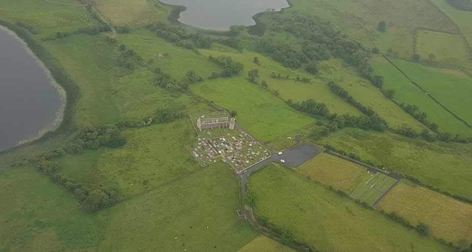
Drumlane Abbey
Drumlane Abbey, Church and Round Tower are believed to have been founded by St. Colmcille and date from 555AD .
=== == == === ====


Some lakes. Ireland is full of lakes. As you can see lots of showers around. I weaved and ducked between the showers. It was easy enough with good visibility.
=== == == === ====
Devenish Island
Devenish Island


Devenish Island is in Northern Ireland, just inside the Enniskillen ATZ.
Wikipedia says
Devenish contains one of the finest monastic sites in Northern Ireland. A round tower thought to date from the twelfth century is situated on the island, as are the walls of the Oratory of Saint Molaise who established the monastery in the 6th century,3 on a pilgrim route to Croagh Patrick in County Mayo.
=== == == === ====
Still in Northern Ireland, we have Monea Castle
Monea Castle


It was built in 1616. Just the shell remains.
=== == == === ====
Some nice lakes in Northern Ireland

=== == == === ====
Back in the Republic of Ireland, this is Donegal Castle.
Donegal Castle

It’s in a built up area, Donegal town, so no low level photo for this one!
It was built in the 15th Century. It lay in runes but was almost fully restored in the early 1990s.
=== == == === ====
Lough Eske Castle
Lough Eske Castle

Originally built in 1474, but the current castle was rebuilt in 1860. It was destroyed by fire in 1939.
It was refurbished in 2007 and is currently a 5* hotel.
=== == == === ====
Here are some random photos of Donegal Bay.


=== == == === ====
InishDuff

=== == == === ====
Slieve League Cliffs
Slieve League Cliffs

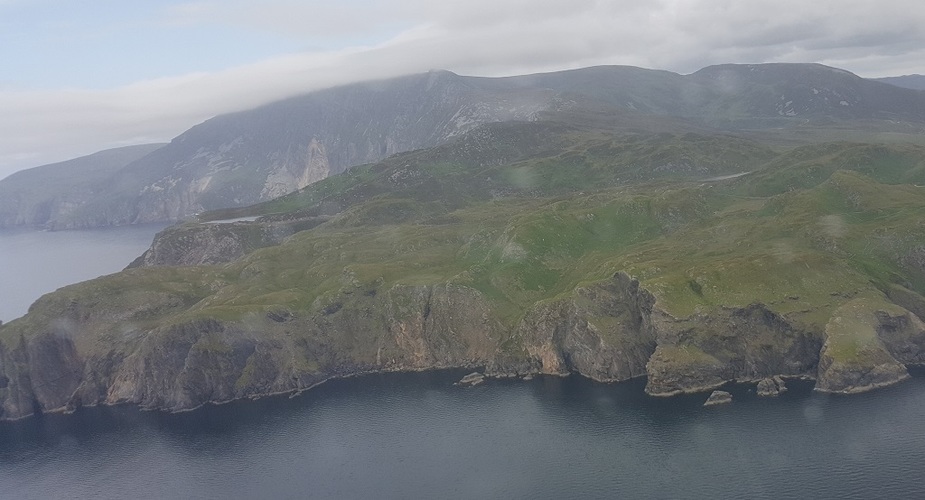


They claim to be “the highest accessible sea cliffs in Europe” reaching a height of 1,972 feet.
Our late departed colleague Dave Phillips was a fan of this cliffs.
They make for some nice photos, the last two above viewed from about 1000ft AMSL
=== == == === ====
Malin Beg Watch Tower
Malin Beg Watch Tower
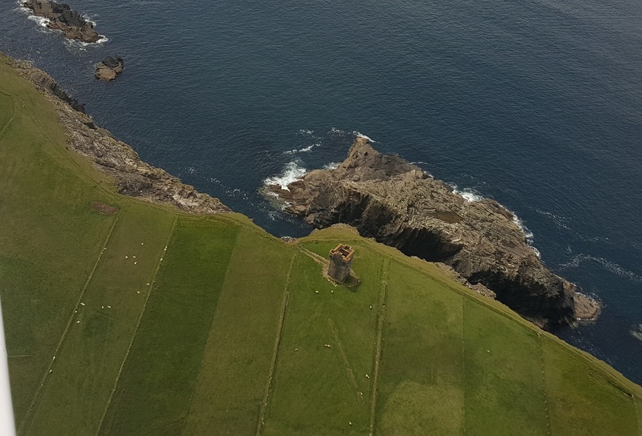
It’s a two story signal tower built in 1805 in reaction to various French invasion attempts.
=== == == === ====
Rathlin O’Brine Lighthouse
Rathlin O’Brine Lighthouse
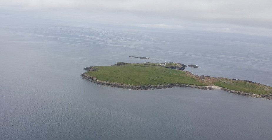
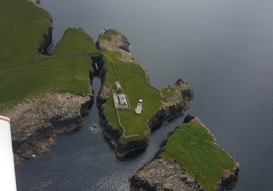
This wasn’t on my original route. But I could see it from Malin Beg Watch Tower and it looked lovely, so I went to investigate. It went into operation in 1856, and had the honour of being Ireland first nuclear powered lighthouse in 1974, powered by an RTG.
I love the stone walls lining the path out to the only piece of land connecting the lighthouse area to the rest of the island.
=== == == === ====
Donegal coastline


If you can imagine Ireland’s shape as a classic teddy bear shape viewed from the teddy’s left hand side, then this is the coastline where the teddy’s face is! The west coast of Ireland, battered by the Atlantic Ocean and its many storms, is much more dramatic and beautiful than the east coast which is washed by the much more gentle Irish Sea.
=== == == === ====
Approach to Donegal Airport
This photo is taken a bit back on the approach where I could get off the centreline to take a photo for EuroGA!

As I got closer, this was as much as I could manage! Too much drizzle around.

This approach consistently wins the award for the “Most scenic approach in the world”.
Personally, I think the approach to Sligo’s 28 is much more scenic.
Do note the lovely big beach to the side of the runway.
They were expecting Travis Ludlow to arrive in Donegal airport that day on his round the world trip. (I didn’t know that! That wasn’t my reason for going there!). He didn’t arrive until a few days later.
=== == == === ====
Beach

This is the lovely beach to the side of the runway. 3 minutes walk from the airport front door.
=== == == === ====
There were loads of lovely camping spots in the dunes. Perfect for a future camping trip. Some up nice and high with wonderful views, and others down in the dunes, nice and sheltered and more stealthy.
This would make a nice spot if not too windy.

=== == == === ====
I found a nice spot for my lunch and enjoyed it looking out over the sea.

=== == == === ====
There were lots of people enjoying the water, even thought the coastal waters in Ireland are very cold to be swimming in! Still, there were a few people venturing in for a swim. I saw others paddle boarding, and these guys kayaking.

=== == == === ====
The sky started to look a little darker around, so I check the METARs and precipitation radar on my phone. It was looking a little worse, even though I’d only spent little over an hour on the ground. But none the less, I’d done what I came to do, so decided to make may way back towards the airport.
Donegal Airport

My planned route would take me further north, and then down through some of Northern Ireland to get some more photo opportunities. But the weather in that direction had remained consistently dark in heavy rain, ever since my approach into Donegal. With deuterating weather everywhere else, it didn’t seem wise trying to find a way through that. So I planned a more direct route home, similar to my outbound route but shaving off some of the corners and photo stops!
Donegal airport, downwind, just after departure

=== == == === ====
Initially the weather looked much like it did on the way up. Isolated CBs doing their stuff, but easy to work around them with a decent cloud base. But it didn’t take long before signs of trouble started to appear!

This was around where the Malin Beg Watch Tower was in the earlier photos. The watch tower was probably on the right most end of land in this photo. The cloud above me was a little lower than on the outbound trip, but this was manageable. The fact that cloud was forming much lower down was a big warning sign and a cause for concern. Having said that, off the land, out to sea, there was no low cloud. So I felt safe that worse case scenario, I could still get back into Donegal or probably Sligo, approached over the sea, if need be.
=== == == === ====
These are the Slieve League cliffs on the return trip, with a lower cloud base.

=== == == === ====
Now things started to get worse. My planned route was now more of a “general direction” rather than a line to be followed! I found myself heading in directions well off my intended route.
As I got a bit more south, I was faced with the Sligo coastline looking almost impassable. There would be much high ground in this area, and all of it higher than the altitude that I was managing to maintain! There was a dirty big black CB sitting over the most likely spot for passage, and it was dumping out its contents making that path impassable. To the left was land all covered in low cloud/fog. Not much land could be seen there. To the right looked a bit better. This was directly over Sligo Airport, I called them up and asked for a transit, which was immediately granted.
I overflew the airport and looked for a way through the high ground beyond it. But I found at the best spots, I was down to 500ft with poor and reducing visibility ahead. This was going into the high ground. While there are low level ways though the high ground, with the poor visibility this would be a recipe for disaster. If I found my way blocked, I’d have no time to make a turn, and no guarantee that I could find my way back out.
So this was a no-brainer. No way was I venturing in there. So I turned around and diverted into Sligo.
Going west and trying to find a way around that way did not look any better, and I figured better take the safe harbour and think about things on the ground. If I came up with a better plan I could always take off again.
I landed a little after 4pm, and was delighted to learn that the airport would be open until 10pm. I did some checks and decided that I needed to depart by 9pm to be able to land back at base with reasonable light. I am night rated, but our airport does not have any lights. And it’s a long time since I few at night anyway. But 5 hours give lots of time for improvement.
Unfortunately the weather never improved. It got better and worse in cycles directly over the airport, but not along the high ground that I could easily see from my parking position. The rest of the country got even worse according to the METARs. Even if I got past the high ground somehow, I wasn’t getting into good conditions.
Despite what I hear in the media about lack of holiday accommodation and price gouging in covid staycation times, I was delighted to see that there were a few reasonable priced places to say in the local area with availability. By 9pm things were not showing any sign of improvement, so I gave up and booked a place just 15 a minute walk from the airport and stayed the night. But a very kind fireman insisted on giving me a lift, so I didn’t even have to walk. I told him it was only a 15 minute walk. But he insisted on driving me. He said “I walked across the apron a few minutes ago and got totally drenched! There is no way I’m letting you walk in that!” The wonderful kindness of strangers! 
I think this was the first time that I’ve ever had to divert and stay over night on a domestic flight in Ireland. The county is small enough that that usually isn’t an issue. A first time for everything.
In one sense, it’s a pity that I didn’t make the decision to stay the night, earlier in the evening. Standhill (the town beside the airport) is a plesant place, but it was all closing up at 9pm. But exerience has shown me that as soon as I give up and walk away from the airport the weathre opens up! So I’m not doing that 
The next morning things were much improved. More like Sunday morning’s outbound flight.
Still lowish cloud over the high ground close to Sligo, but easily manageable.

=== == == === ====
Things starting to improve


=== == == === ====
By the time I got into the flat midlands, things were lovely again.

=== == == === ====
This is our Piper Arrow II back at our home base EIKH after an extended day trip.

So the sights that I’d planned to show you on the return trip, will have to wait for another day!
But since I found a lovely camping spot nearby Donegal airport, it hopefully won’t be long before I’m back there. So hopefully I’ll get to share those locations with you soon enough!
Landing fee in Donegal was €12 for an SEP. Overnight outdoor parking is €10 and overnight hangarage is €12.50.
Nice (challenging) trip, it seems dew = temp is a local feature in Donegal but at least half of the coastal scenery was there
@dublinpilot great trip report, a Sligo-Donegal-Enniskillen trifecta would make a lovely Ireland visit
It’s great seeing a precautionary diversion and into a nice town
Once again very inspiring. Although Ibra is probably right, droughts don’t appear to be a major problem Is camping allowed on public land? Private grounds? How could tell public from private?
The weather in Donegal is amazing. If you don’t like it wait 15 minutes. My wife got caught on her solo XC qualifier going from EGAB-EGAE-EIDL-EISG. The weather on the leg from Derry to Donegal went down to 300ft OVC in 1km viz. She stayed in visual contact with the ground, ATC suggested she try landing on a golf course but stuck with it, and found the airport. I found her at the airport bar drinking brandy with another hardy soul, James Dolan who is local with lots of adventure under his belt. He got caught out too. The good thing about that area is you have Sligo/Derry/Enniskillen and many other shorter strips too that you can divert into.
Great report and perfect decision! Thank you for the nice pictures.I hope we will make it to visit Irland in the near future again, seeing all that is so inspiring.
I think this was the first time that I’ve ever had to divert and stay over night on a domestic flight in Ireland.
From time to time I had it on short trips in Germany as well. No chance to pass a squall line and an early closing airport was leading to overnight stays in unplanned places.
Great post. I grew up near EGAE and my first “long” trip up from London will be to there once I decide between going west then north, or north then west.
I say “long” because I’ll need to work with the weather especially as I do want to go via EIDL.
Like Scotland, Ireland is beautiful in the right kind of wx
Interesting Q about camping. In England, “wild” camping is illegal in most places. In Scotland it is legal.
A good writeup, and the west coast is beautiful. Also interesting to read some real-world weather problems, with a happy ending