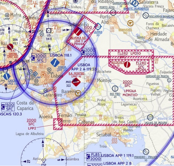
Anyone used any of these for VFR? Any good?
http://flyermaps.com/
I fly with SD on tablet and air nav pro on my phone as backup. For Portugal there were no 500K VFR raster maps available until these guys came along, as far as I know.
I’m about to buy them, as I’m using only an openstreetmap overlay right now…
Interesting maps. Haven’t seen them before
I can’t find any pricing on the site. They say they are available in PNG and GeoTIFF (which means they could run under any moving map that supports the projection used (which I guess is rectangular (Mercator?) and Oziexplorer certainly would support that. But these formats cannot be copy protected…
For Portugal there were no 500K VFR raster maps available until these guys came along, as far as I know.
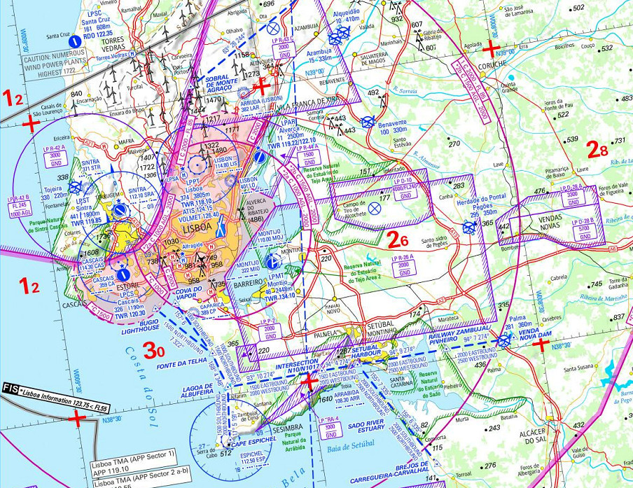
The Jeppesen 1:500k charts existed – abandoned in 2013. This screenshot from Flitestar shows the extent of the relevant coverage (grey areas)

The 2013 Jepp charts exist “in the wild” in Oziexplorer format, as well as jpeg. Here is the piece of the 2013 chart:
And of course the Jepp charts live on in Mobile Flite Deck VFR and are updated monthly. It is not clear to me if the flyermaps are static or dynamic with AIRAC updates.
Peter wrote:
I can’t find any pricing on the site.
On air nav pro I have the option to buy Spain + Portugal for £17.81 which is not bad considering it includes the entire Spain.
Peter_Mundy wrote:
t is not clear to me if the flyermaps are static or dynamic with AIRAC updates.
I suspect they’re static. i.e. when a new map is out you pay for it again. Similar to buying paper charts actually.
They may be static, or may not be… if I was publishing maps, and given that I would obviously be doing this using some layered CAD package (as of, ahem, AutoCAD, c. 1982  ) I would be updating it continuously, because it doesn’t cost any more to do that, and given the end product is published online, it can be constantly current.
It would also be a great selling point. A point lost on Jeppesen’s electronic “VFR/GPS” charts for Flitestar (along with their paper charts, abandoned in 2013) which came out only once a year, even if you had the 13-cycle AIRAC update DVD sub!
It is only printed charts, distributed and sold via pilot shops, which cannot be updated like that.
It’s such a great market that Jeppesen chose to abandon it
I think the discussion paper or paper-like maps versus dynamic vector based moving map apps is mostly over. The moving maps won.
achimha wrote:
I think the discussion paper or paper-like maps versus dynamic vector based moving map apps is mostly over. The moving maps won.
Yes I agree. In fact my primary is a tablet with SD. But it has packed up in the past (due to an Andriod bug upgrade). Air nav pro is backup. Air nav pro has also crashed on me a few times.
The problem I have over here in north Portugal is that the SD charts are not that detailed. They got much better in the last update, however a few months ago I tried keeping to my route by just using a printout from SD and using DR. I failed miserably and resorted back to my tablet.
I also used Airnav Pro in the past, but IMHO they are absolutely not up to the standard of SD, so I switched over circa 2012.
Since the SD subscription is valid for several (3?) devices, I see no reason to use another software as backup. I don’t think the software per se will/can pack up on several devices at the same time in flight.
Interesting maps. Haven’t seen them before
They look like the worst of both worlds. Someone has taken some kind of generic base map, and then – using a not particularly intelligent algorithm – layered the digital AIP data on the top.