Why coouldnt you get breakout reports of aircraft in the radar approach environment?
Radar can't see cloud unless it is full of water. And most ATC units don't have weather radar.
In Croatia ATC is usually responsive about weather but traffic here is no busy :) Sometimes they check and give you info on tops based on response of the pilots in vicinity.
I don't think one can do a simple "shade of grey" to cloud top height conversion, because the shade of grey, in the images which all come from EUMETSAT, corresponds to a temperature, not altitude.
Peter, SAT24 depicts Visual and IR imagery separately. Are you saying that Visual isn't really visual but derived from temp sensors?
Now, what about us just starting this? I mean, what about us asking controllers whether they could be so kind to check with an approaching/departing airliner to give some cloud top info before you take off?
I have asked German and Belgian controllers about cloud tops on more than one occasion, and they would either give it right away, or tell me to stand by until they have a chance to ask.
Peter, SAT24 depicts Visual and IR imagery separately. Are you saying that Visual isn't really visual but derived from temp sensors?
The visual image is AFAIK just a visual image, in B&W. It tells me very little. About the only useful things it tells me is if the sky is totally clear, or if there is a known fog bank one can see what it is doing. And of course it is black over ground on which there is no daylight.
The IR image is a thermal image, valid H24, and there is a direct temperature scale which could be provided, but - of the images that are free and appear with a useful latency i.e. not something silly like every 6 hours - neither of the two images I know about (UK Met Office, and SAT24) provides such a temperature scale.
There is a site which does provide a temperature scale but it needs a paid subscription AFAIK - here it is
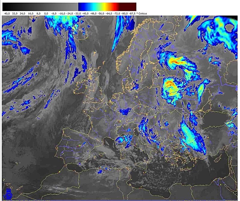
There was a Spanish site which corrected the cloud top temperature with the "known" (presumably extracted from GFS) temperatures aloft and displayed an altitude scale. That of course is the holy grail, but that URL went dead after a few months. Perhaps somebody, seeing the URL, might find out who was behind it.
I am flying a Cirrus SR22T which is fully certified for flight into known icing conditions (FIKI) up to FL250. My experience is that this gives me the possibility to basically fly most of the time. OK. I still have to carefully look at the weather forecasts, make sure I do not end up in developed CBs and heavy frontal weather or heavy clear icing situations, but so far the FIKI system has worked fine.
As for the oxygen, you can buy the SkyOx bottles at the pilotshop in Lelystad, but I have resorted to Mountain High pulse regulators mounted on the SkyOx bottle or linked to the in-aircraft oxygen supply in the Cirrus. I just can't imagine flying without oxygen.
Personally, I don't wear the masks but add a boost of extra oxygen flow on the Mountain High systems and use the cannulas up to FL250 checking carefully the oxygen saturation in my blood with a O2 oxygen meter.
I cannot out climb all the weather, but with the FL250 service ceiling of the Cirrus I can out climb about all weather. I normally file for FL180 and ask for a stop climb in I am in VMC conditions on top or climb to FL180 for better performance/speed. If needed I ask to continue the climb to FL250. Most of the time in winter, the temperature is far below -20 degrees Celsius and even if in the clouds I do not notice any ice once up there. The deicing feature in the Cirrus is used quite a lot and one of the best features they added.
I am also flying a Piper Archer III, but then I will stay at max at FL120. Even at these flight levels or at night even down to FL50 I use oxygen and notice that it really makes a difference in how fit I will once I arrive.
In the AeroPlus Aviation Weather app for iPhone/iPad a Skew-T/Log-P diagram is depicted showing the atmosphere. The data comes primarily from the GFS weather model. Where the ambient temperature and dewpoint temperature meet, there is a good reason to think of clouds there. OK. There is also a vertical lift component that is not taken into account, but if the 2 temp lines are far apart, the clouds will not be there. Take this and add the IR cloudtop temps SAT images and you get a fairly good idea of where the top of clouds would be.
When on the ground or tower frequency, ATC controllers often don't get an opportunity to ask the airline pilots for where the actual cloud tops are. They hand the pilots over to control/approach frequencies right after departure. However, if you ask while climbing to an enroute controller, you will get an answer. Sometimes even from the airline pilot on the same frequency.
Peter 06-Feb-13 16:07 #26 That site, Aart, is unbelievable.
I know Ogimet but this must be a recent addition.
Basically they are plotting GFS data but it's very nicely done.
The basic site is here. One can enter just one ICAO code, for a "spot" report, or two or more for a "route" report e.g. EGKALFMDLDSP
This is amazing. Meteoblue would do a "route" but it used dodgy java code which crashed a lot, and this is much better.
Unbelievable how well it is done. They show the selected flight level as a yellow line and, just for perfection, they adjust it for the actual pressure... you also get data along the route, for the selected level.
Just wondering if anyone has been trying the reliability of Ogimet. On a recent flight to and from Basel it was spot on, but that is just one datapoint. Any volunteers to try it out regularly and share their experiences? Thanks..
Ogimet's GRAMET renders GFS data with some custom algorithms to determine icing conditions. It is therefore as good as everything else that is GFS based. It has become my main tool for enroute planning.