If they asked for a cloudbreak to descend to 6500 they probably realized it wasn’t “just safe” to descend there. At 6500, below cloud, they were flying along a ridge, so by then IF they thought 6500 was “safe for the area”, experienced pilots would have realized that something was really wrong with their prior assumptions (and I assume would have talked to ATC/ immediately climbed at full power and Vx (and possibly reversed course)
Would you think like that if you hadn’t seen the TA6500 on the map?
The “6500” could well have caught me out. I found that pretty scary when I saw it.
It so happens I don’t do that sort of arrival into a “canyon airport”; I fly at say FL150 to overhead, cancel IFR, and then spiral down, or fly the IAP under VFR. Locarno, Bolzano, Zell am See, etc. Or spiral down to hit the start of the published VFR arrival route. And if not visual with the airport from FL150 I would divert. So this exact scenario, going to Albertville, would not have happened to me. But very few pilots fly that way. Most fly via the canyons, or go there above the terrain (in VMC hopefully).
PS: of course you can change the PIC role during a flight (although I don’t know the rules for Germany – are they different).
No, same rules in Germany. You can change the PIC – just inform the operation control center (in case of airlines) or inform ATC in case of GA.
PIC changes are sometimes necessary during upgrade training first officers to captains depending on wx conditions and ratings.
172driver wrote:
These guys had a perfect valley to fly along below the overcast, yet to save perhaps two or three minutes elected to scud-run in mountains.
Do we know that or are we following the BEA’s assumption in that? This is merely based on the report of the instructor awaiting them at Albertville, and their flight track. Is it maybe possible that no detailed briefing about which valley to follow from Chambéry was made, or that there had been a misunderstanding, or that they just took a wrong turn because they weren’t familiar with the area?
This whole “they killed themselves to save a few minutes” innuendo to me sounds highly speculative.
BTW, can someone draw this out on a map for me, i.e. the “good valley” vs. “valley they flew into”, because from the report I can’t really see that. Or maybe please point me to the page where I can find such a drawing.
Rwy20 wrote:
BTW, can someone draw this out on a map for me, i.e. the “good valley” vs. “valley they flew into”, because from the report I can’t really see that. Or maybe please point me to the page where I can find such a drawing.
The advice of the FI was as follows:
Qu
L’instructeur précise qu’il avait suggéré au pilote, dans
le cas d’une météo défavorable, de faire une percée ILS à Chambéry pour passer
sous la couche puis de poursuivre vers le sud vers le point SE de Chambéry pour
contourner le massif des Bauges puis de remonter vers le nord-est par la vallée en
direction d’Albertville.
Which makes me think he suggested this (blue imprint on the map is mine):
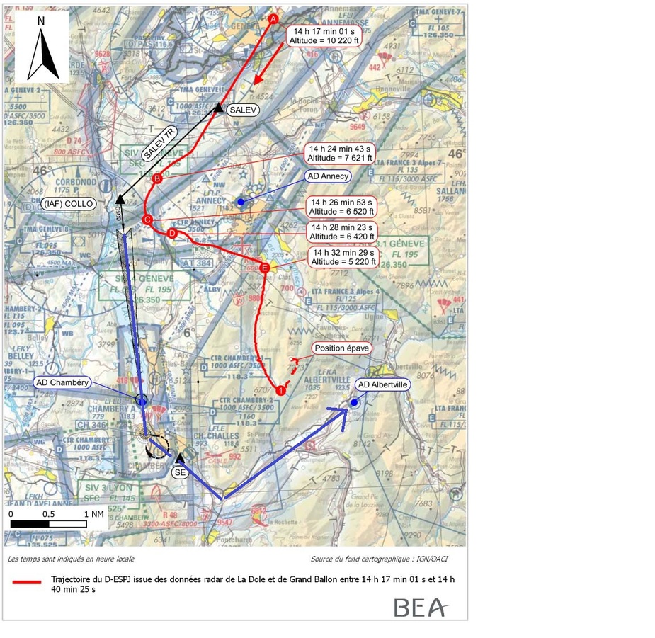
He suggested to fly the ILS and then proceed to the VRP SE and from there to the south, then turn towards the north east to Albertville.
They did not follow that but turned left towards the Lake of Anncy to “fly direct” as they told ATC. Obviously they got ground contact somewhere between point B and C and threw away the approach as they thought to be safely under the overcast.
If they flew direct, the outcome was obvious as the valley they chose was a dead end. Both, the way around to the west and the way around the east via Faverges and Ugine and approach from the North-East would have been possible.
Classical mistake in the mountains, has happened to many people.
Mooney_Driver wrote:
Both, the way around to the west and the way around the east via Faverges and Ugine and approach from the North-East would have been possible.
OK, thank you, that makes sense. Still, we don’t know if what the instructor told the BEA is also what he told verbatim to the pilot before. And secondly, we don’t know if he had understood that plan the same way. Sometimes, if you are communicating, over the phone, with people in a language that is not their native language, there are misunderstandings or bits of information that just get lost.
To me, the right turn at the point marked “E” doesn’t look like a shortcut as opposed to following the valley via Faverges and Ugine, as you write, and which would have been the logical plan B if you didn’t want to fly around the south.
As you say, taking a wrong turn in the mountains when the tops are in cloud has killed many pilots already. Even without cloud it can be dangerous, if terrain starts rising and you run out of space for a 180 before you notice it. This was a bit different admittedly.
Rwy20 wrote:
To me, the right turn at the point marked “E” doesn’t look like a shortcut as opposed to following the valley via Faverges and Ugine, as you write, and which would have been the logical plan B if you didn’t want to fly around the south.
Yes, I have also been thinking about that. But then again, missing the lake of Annecy pointing into that valley they should have taken is a pretty large thing to miss.
I’ve flown up parallel valleys before and also messed up but always in weather which made a change over the ridge to the next one a non-event. Flüela Pass from Davos has a parallel valley which is very easy to muck up and is a dead end too.
The left valley here is the correct one… the right hand one is much more prominent though.
They originally briefed for the ILS cloudbreak, according to the report, and broke off before joining the localiser, making a left turn towards Lake Annecy. They then flew to point E and turned right. Along a valley that was blocked by cloud and rising ground above their level. The witness on the ground at point 1 stated that the aircraft made " two or three tight left turns before eventually flying northwards." This is in the area where the radar is partially blanked by terrain, so the tight left turns don’t show on the trace, but it is a credible witness (a microlight pilot).
It looks to me as though the ILS south westerly route was plan A, the Easterly route via Faverges and Ugine was indeed the plan B that would have saved a little time, and that they initially thought that they were following this route, but did not realise they had picked the wrong valley. The second witness describes the abrupt left turn, which must have been in IMC because it was directly into terrain. That witness describes “banks of fog and cloud” They were too low to be able to get radar, or any effective VOR or ground based nav, and they were seemingly relying on tablet GPS.
I was flying in cloud today when my iPad running Skydemon lost contact with my wifi GPS for a few moments. Fortunately I was at 3200’ over Oxfordshire. What if this happened just at the time I was relying on it to find my way out of a dead end valley in the alps in quasi IMC, while below the top of the mountains, and unsure of position…? Or what if it had not been working at all….and we were using paper maps, which would explain the scenario of taking a wrong valley. In fog and low cloud.
The BEA report mentions that the flight tracks on the iPad were recorded in the background of the application by airnav pro. Or should have been, yet there were no tracks recorded at all on the day of the flight. Tracks had been recorded on a previous flight, on 13th November. The BEA say that their examination of the iPad had not produced any explanation for the lack of track recording, but they suggest that the iPad was not being used for navigation at the point of the accident.
I’m repeating myself but they were visual at 5000 ft and they were climbing moments before impact, so I can conclude that “6500” wasn’t confusing factor. To me it seems that last left turn into terrain was involuntary, possibly made by inexperienced pilot in IMC. Without that turn, at the time of impact they would be at 7000 ft (or higher) flying northbound and above terrain.
What the flight instructor told the BEA is also what he told verbatim to the PIC before.
Dito we can also quite safely assume that Stefan had understood that plan to use the ILS approach for safe cloud breaking the very same way.
The “6500” might or might not have been the confusing contributor.
Assuming the general adequate situational terrain awareness of the crew of the Isere vallee, a DCT shortcut
would not have brought any flight time benefit, due to the descent restricting mountain ridge on the DCT FPL path.
The necessary steep descent profile would also not have been in the style the PIC used to treat his SEP.
“E” does rather look like the intension to follow the valley via Faverges and Ugine, as valid alternative option B
if they did not want to fly around the south as originally planned for whichever reason.
Misidentification of the valley especially under the prevailing weather conditions can easily happen
especially as neither the used electronic nor charting navigational can be decided in hindsight.
Human error or reduced human performance could have evolved following hypoxia negatively affecting decision making
due to the prolonged flight time at an DA of more than 14.000’ in spotless VMC, if the O2 supply would not have been working as expected.
We will probably never find out the why the quite sound plan was tragically altered by the crew at the final stage of flight, so sad – RIP Stefan.