
I take your point Tom….you are right….if you can get realtime strikes telemetered it would be superior…
But some (many) people have a stormscope of sorts in the panel already….and no datalink…
@Flyer59 – replying a bit late, so quoting a bit more:
Do you not agree that these systems can help a lot in avoiding serious wx? I was a bit surprosed by your sceptical answers in the other thread. Is a 15 minute radar image update useless in your eyes?
There are two statements that I read quite often that are dangerous
- One can easily substitute a GPS for a DME during approach
- The ADL120/XM Weather/Whatever can replace radar for avoidance of embedded convectivity
They are so dangerous because they are true 99% of the time, and the remaining 1% then kills you.
I think the ADL120 is VERY useful. In the same way that GPS is VERY useful, and using GPS for lateral navigation instead of ADF/DME is again great
I really only ever disagree with one thing – that they are good SUBSTITUTES for the other technology in ALL cases, which many testimonials frequently make them to be.
These systems all have different sweet spots
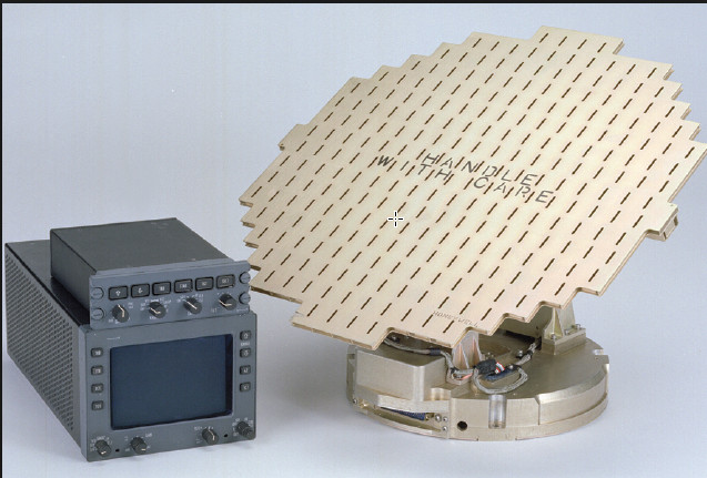
Stormscopes are a bit funny – they serve as a “poor man’s” radar in singles, and can augment the radar picture, but most radar equipped aircraft do not bother with additional stormscopes. Never flown anything with both installed at the same time, so can’t really comment here, my current steed only has Radar.
Of all of the above, the ADL120 is easily the most cost effective, and I completely understand people who would not spend additional money on stormscope or radar. Especially if they have no intention flying through frontal weather with embedded CBs.
Cobalt wrote:
Stormscopes are a bit funny – they serve as a “poor man’s” radar in singles, and can augment the radar picture, but most radar equipped aircraft do not bother with additional stormscopes. Never flown anything with both installed at the same time, so can’t really comment here, my current steed only has Radar.
Indeed. With ADL-120 and RADAR I would never bother with a stormscope.
The range is not fiction, it is an approximation from a calculation. Early systems used a single frequency and signal strength against a standard value. They have a fair amount of radial spread where a particularly strong storm will show strikes closer to your location than they are. However, If you know how to interpret it, you know where the storm is and how to avoid it. I use the radial spread to indicate strength and the clustering to indicate approximate location. Later systems use a two frequency analysis to determine the cell distance, taking advantage of the fact that different frequencies travel at different speeds thru the atmosphere. This improves on the distance calculation, Also included in the depiction, the rate of strikes, as this gives one continuous visualization of the activity. The azimuth is very accurate.
This is an anecdote told to me verbally many years ago, so I can’t verify its authenticity, but my own experience over 35 years of using this tool bears it out. Two twins were on a round the world trip. One was equipped only with radar and the other only with a Stormscope. The radar equipped aircraft was hit by lightning and experienced severe turbulence. The other had a nice trip without turbulence.
I would not use a Stormscope to penetrate convective activity, nor would I use Nexrad for that purpose. A good onboard radar system supplemented by a Stormscope is what I would chose to pick my way thru a storm. A Stormscope can be used to circumnavigate the storms as can Nexrad. They may both be used strategically to avoid the storms, but are not suited for penetration. Since I am a non commercial flier, I don’t have a need to penetrate any storm, I can go around it, land and wait it out, or not go in the first instance. It makes no difference to me if a storm is 25.27 miles away or 35 miles away, I am keeping my distance. If a storm is off my nose and 150 NM away, I will follow its progression. As I get to 100 NM, I will likely be adjusting my course to avoid it. If I can’t get a clear path forward at 50 Nm, I start evaluating landing sites. At 25 NM, I am landing if I can’t circumnavigate it. The Stormscope is a tremendous aid in safely navigating away from and around convective activity.
It is interesting to see how diverse the opinions are about the utility of stormscope, including in the present thread. They range from totally useless to very reliable (with no specific reference to this thread).
Is there a consensus to say it is a useful tool when used in conjunction with other information like a satellite image or weather radar?
Aviathor wrote:
Is there a consensus to say it is a useful tool when used in conjunction with other information like a satellite image or weather radar?
I think it has use, but for a casual user, its usefulness of frequently overstated.
What is not being mentioned is the cost of satellite data.
There is no free lunch, and in Europe there is no free delivery of anything to the aircraft. I don’t have an ADL120 so will leave it to others to post actual figures, but this is relevant, otherwise one could just say “I have radar and it’s great” while not adding that theirs is a Honeywell Primus 880 which costs, what, 50-100k? It’s like saying “I fly for work and never worry about lightning” without adding they fly this. Capability comes at a cost and there is a spectrum on which different solutions sit.
I agree with NCYankee about stormscopes. My WX500 shows azimuth to better than 10 degrees (I rarely do IMC enroute and never in sferics wx, so usually see where the strikes are coming from) and the distance is usually conservative by a factor of 2×. So if you use it as “don’t go there” it works great. Almost any SEP can have a stormscope, too, and it weighs almost nothing, but almost none can have radar retrofitted.
Another thing is reliability of the data feed. Satellite data is not 100%. Iridium is probably a better than Thuraya (T. fails totally on 5-10% of flights, presumably because the engineer on shift is off to feed his camel, but Iridium also sometimes fails, and trip reports from expeditions to remote places often mention this) but a stormscope, like radar, is a standalone bit of kit which will always work unless it is buggered.
Tom – no, I didn’t think Blitzo are pushing out a new GIF every minute, but the URL I posted doesn’t auto update. You have to refresh it, and then you get a new plot. Or are they sending out the strike coordinates to a javascript client app which plots them in the browser window? If so it would be easy to create a georeferenced (aircraft in the centre) image on any airborne client which has internet access (Thuraya is much faster and cheaper than Iridium) and has access to GPS position (which every airborne tablet should have, Ipad internal GPS “reliability” notwithstanding).
A 3 day trip kit is € 9,00 plus € 0,29 for each paket of data.
You need about 4 pakets per download, € 1.07 per download of Images plus a couple of METARS and TAFs.
A 2-weeks trip kit is € 25.
SMS is € 0.29 outbound, € 0.19 inbound.
That’s what I do.
You can also buy a subscription, that’s € 29.50 per month, but I don’t need that, because I only use it on the long IFR flights.
NCYankee wrote:
The range is not fiction, it is an approximation from a calculation.
That almost sounds like marketing speak 
The problem with stormscopes is that they measure a quantity that’s not a good proxy for range and that is strongly dependent on other non-related properties.
Stormscopes essentially measure the magnitude of a strike signal in the very low frequency band and compare that to an “average” strike. Now the problem is that there’s no such thing as an “average” strike, each strike is massively different from the others. That doesn’t even affect only the magnitude, but also how the waveform looks like. A strike can easily be 10dB (factor of 10) stronger or weaker than the “average” strike. A factor of 4 translates into a range error of factor 2, so a strike can easily be a factor of 5 farther away or closer than what comparing the measurement with the model strike results in. So we easily have a factor of 25 uncertainty in range.
NCYankee wrote:
Later systems use a two frequency analysis to determine the cell distance, taking advantage of the fact that different frequencies travel at different speeds thru the atmosphere.
That cannot be true, as the speed difference is very minimal, and certainly not detectable within the low bandwidth of a stormscope (frequency range roughly 10-70kHz).
What one could try to exploit is the difference in attenuation at different frequencies, but that again suffers from the fundamental problem that strikes don’t really adhere to some “standard waveform”. I suspect there’s an effect of the discharge channel length to the frequency content. I would be surprised if the ends of the ionized channel were impedance matched, so I suspect there’s a standing wave in that channel.
And you cannot use much higher frequencies, as those would be attenuated too much and only useful for strikes closeby, and you’d be susceptible to interference from radio stations (such as NDB’s 8-)) [ 1 ]
Have you once connected a VLF antenna to an oscilloscope when there was a thunderstorm nearby? It’s very interesting, I haven’t seen any strike waveform that is similar to another, all looked very different from the others.
That’s why in my opinion time of arrival methods as used by Blitzortung.org and others are so much better. It simply needs to correlate the strike waveform at several receiving sites, and correlation is pretty robust against channel effects and interference. The only downside is you cannot use it on a single aircraft alone, as the maximum distance between the receivers would be much too small to provide a meaningful geometry.
Peter wrote:
What is not being mentioned is the cost of satellite data.
Well, 10k$ buys quite a lot of data, even from Iridium
Peter wrote:
but the URL I posted doesn’t auto update
I don’t know. The main page and all maps available from there do, using the websockets method I described. But the websockets method requires a reasonably modern browser for the websockets support, that certainly rules out Opera on Symbian…
NCYankee wrote:
However, If you know how to interpret it, you know where the storm is and how to avoid it.
That can be said of weather charts too, isn’t it? If you are at liberty to stay at home whenever there’s a chance for thunderstorms, you can operate as safely without a stormscope as with. So the only benefit of the stormscope is that you can safely operate closer to thunderstorms than without. But that benefit strikes me (no pun intended) as rather marginal.
Furthermore, the stormscope (and blitzortung.org) only paints the actual picture, it is no forecast. You could happily fly with a clean stormscope in a high CAPE area with an inhibiting layer eroding away, undetected by you, then suddenly without much warning time all hell breaks loose around you.
I cannot remember many flights I cancelled because of potential thunderstorm activity and IMC – maybe one flight project during the last five years.
Anyway, we’ve had that debate already here
[ 1 ] According to the Ryan patent their stormscopes work from 10kHz to 70kHz. We have fairly high power timecode transmitters like DCF77 (50kW antenna feed line power, estimated ~35kW EIRP) close to that frequency band. Has anyone seen stormscopes being affected by that?
So we easily have a factor of 25 uncertainty in range.
That is not the case in reality, however. Why not, I don’t know.
that certainly rules out Opera on Symbian
I stopped using those early in 2015 
That can be said of weather charts too, isn’t it? If you are at liberty to stay at home whenever there’s a chance for thunderstorms, you can operate as safely without a stormscope as with. So the only benefit of the stormscope is that you can safely operate closer to thunderstorms than without. But that benefit strikes me (no pun intended) as rather marginal.
Not sure I understand. A stomscope shows where (azimuth) there was a strike, and if it shows a cluster of them then you have a TS there, for sure.
Charts and wx models are no good for showing where convective activity will actually happen.
Furthermore, the stormscope (and blitzortung.org) only paints the actual picture, it is no forecast.
Convective activity cannot be forecast as to location. All that could possibly be forecast is the PROB.
I cannot remember many flights I cancelled because of potential thunderstorm activity and IMC – maybe one flight project during the last five years.
That depends on what flying you do
Has anyone seen stormscopes being affected by that?
They are very much affected by radar e.g. the sort found on TBMs, PC12s, airliners… but the event is obvious from the lateral extent of it.


