I have looked at many radar charts where ATC MVA (or ATC DCT) minimum altitudes in terminal airspace sits way under the legal minimum cruise altitude, I gather it’s related to definition of obstacle margins and protected areas
How that is compatible with the requirement for commercial airliners to be on published procedure before descending bellow minimum safe cruise altitudes? do vectors & directs in terminal airspace count as published procedures? or cruise MSA is simply overridden by MVA in radar environments?
Can someone operating under Part-CAT fly down to RNAV1 MVA on his own equipment without being on ATC vector or ATC direct? say flying OCAS without ATC or when talking to non-radar ATC units in CAS
What about “resume own navigation” should one climb to cruise MSA?
Ibra wrote:
or cruise MSA is simply overridden by MVA in radar environments?
@lbra sort of answers your question. Typically ATC will advise you track miles to touchdown when descending you below MSA, as a cue that you are now in their MVA which is published on the airport approach charts. Most multi-crew will have a crew member monitoring the MVA and PF would call out when descending below MSA, MSA Vectors.
Ibra wrote:
or cruise MSA is simply overridden by MVA in radar environments?
Yes. When vectoring – or indeed whenever giving a direct clearance – ATC is responsible for obstacle clearance.
Can someone operating under Part-CAT fly down to RNAV1 MVA on his own equipment without being on ATC vector or ATC direct? say flying OCAS without ATC or when talking to non-radar ATC units in CAS
I don’t know part-CAT, but for part-NCO yes, assuming the obstacles clearance used when determining the MVA is at least as large as the usual 8 km and 1000 (2000) ft.
What about “resume own navigation” should one climb to cruise MSA?
ATC still has responsibility for obstacle clearance until you’ve rejoined your flight plan route or other published route.
SERA.8015(b)(6): When vectoring or assigning a direct routing not included in the flight plan, which takes an IFR flight off published ATS route or instrument procedure, an air traffic controller providing ATS surveillance service shall issue clearances such that the prescribed obstacle clearance exists at all times until the aircraft reaches the point where the pilot re-joins the flight plan route or joins a published ATS route or instrument procedure.
Yes ATC has responsibility for vectors (and directs recently) but why that makes it legal for PIC to descend bellow MSA for CAT? is AirOps not applicable when ATC are in charge of obstacles in the abscence of procedure? or published MVA chart count as “published IFR procedure” by the state?
assuming the obstacles clearance used when determining the MVA is at least as large as the usual 8 km and 1000 (2000) ft.
But most MVA charts are 1kft (2kft MOC) +/-1nm (+/-2nm) as radar operations are RNAV1 or RNAV2 depending on equipment (there is some temperature correction as well) but sometimes you get vectored near obstacles 2nm away
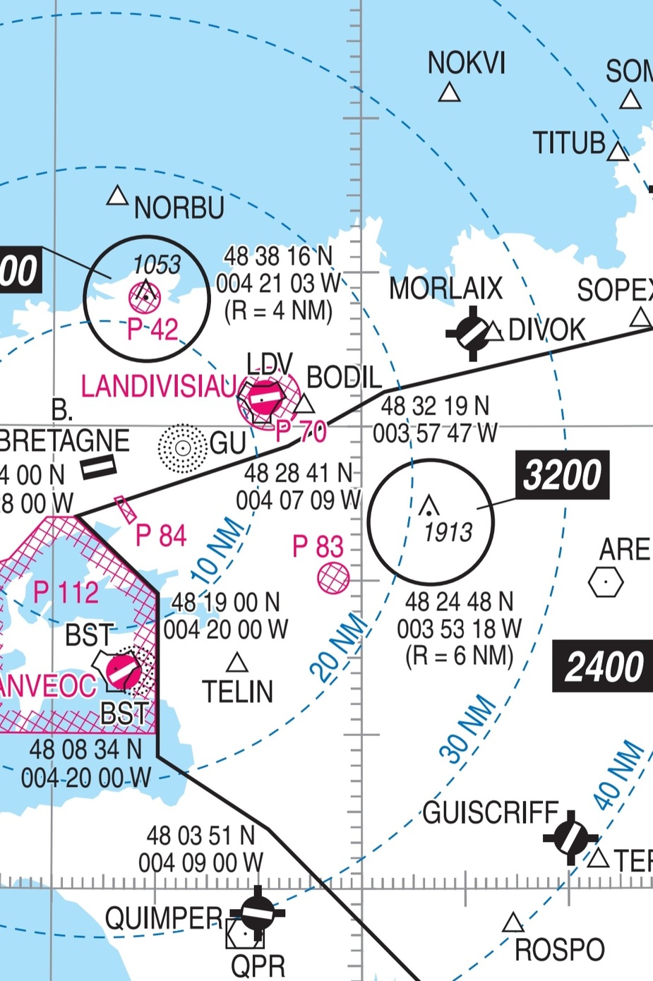
At Brest, you could be vectored at 2500ft with 1nm away from a pylon at 2000ft
Typically ATC will advise you track miles to touchdown when descending you below MSA, as a cue that you are now in their MVA which is published on the airport approach charts. Most multi-crew will have a crew member monitoring the MVA and PF would call out when descending below MSA, MSA Vectors.
How was it in the old days with RNAV5 equipemnt only if you lose radio on radar vectored ILS before reaching the LOC?  or DME/DME was obligatoire
Ibra wrote:
At Brest, you could be vectored at 2500ft with 1nm away from a pylon at 2000ft
I doubt that’s correct. Where would it be on the chart?
Yes ATC has responsibility for vectors (and directs recently) but why that makes it legal for PIC to descend bellow MSA for CAT? is AirOps not applicable when ATC are in charge of obstacles in the abscence of procedure? or published MVA chart count as “published IFR procedure” by the state?
Can you refer to the specific paragraph in part-CAT which says this?
I can’t work out some of the above posts (maybe missing punctuation) but ATC is responsible for obstacle clearance when (and only when) you are being vectored. CAS or OCAS is irrelevant.
I doubt that’s correct. Where would it be on the chart?
You are right, I just double checked at every point of the MVA chart, the aircraft is above +/-8km MSA at that point
Generally speaking ATC will vector shortcuts below MSA under vmc condition from my experience.
Also for example “our” company policy is to only accept vectors below MSA day time only and when visual with terrain. And that’s the case with ATC too, they often ask are you visual before issuing below MSA vector, clearances
That make sense, thanks !
Evo400 wrote:
Generally speaking ATC will vector shortcuts below MSA under vmc condition from my experience.
Also for example “our” company policy is to only accept vectors below MSA day time only and when visual with terrain. And that’s the case with ATC too, they often ask are you visual before issuing below MSA vector, clearances
This might seem pedantic, but do you mean MSA or do you mean Minimum Radar Vectoring Altitude (MRVA/MVA)?
It is completely normal for ATC to vector below MSA in all conditions whenever they are still keeping you above the relevant MRVA – in fact I would nearly say it is more common than not for destinations I fly to that we end up on a radar intercept which is below MSA (but still above MRVA). I am also familiar, and do agree with the concept of being vectored below MRVA but only when declared visual with terrain, which usually comes as a clearance like “Maintaining visual seperation with terrain, descend altitude 2000’ cleared ILS rwyxx)”.