I’m pretty sure it’s not that, otherwise places like Rochester and Sherburn would get a steeper slope, rather than the none they have at present.
What do we think they mean by “published data”?
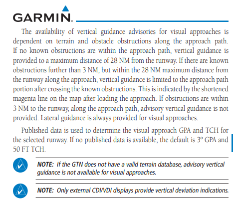
Most likely, the various published terrain and obstacle sources that provide the input to Garmin’s licensed obstacle and terrain databases.
What do we think they mean by “published data”?
Ok, so garmin aren’t quite correct on that claim, published data for Egns 08 has been 3.5 deg for a long time, but they used default 3 deg, but now lat only.
Perhaps it’ll be 3.5 soon, or it being offset might be the reason for lat only. Not that it matters much where a procedure already exists, but handy where none exists…IMHO
I asked Garmin about this a few weeks ago following customer questions and received the following:
Wouldn’t it be loverly?
I have asked Garmin and await their answer.
But this is on 3.51, not 3.62, so it’s not like it’s a recent change.
Maybe Garmin are looking to tie their visual approaches up with the ils/papi etc slope, now they have been in existence for a while?
There are plenty of places with 3.5° or more PAPIs, but a 3° slope. eg Biggin 03 and many others, but I have never seen a Visual approach with more than 3°.
the database does not take local regulations into account.
I don’t believe that a database is used as such. I think it’s calculated on the fly from runway orientation and the terrain/obstacle database.
I just sounded like he possibly flew the straight in visual to 07, which sounds very unlikely.
Quite, the filthy lice infested boids don’t like it. But I am always reassured that the world’s Police is out there looking after me.
Interesting, EGNS used to have a 3 deg. Garmin visual on 08, latest Airac now only gives lateral due terrain.
ILS is 3.5 deg
Timothy wrote:
I had a strongly held belief that GTN Visual approaches were 3° or nothing, but yesterday into EDAZ 07 I got 3.5°.
EDAZ has a 3.5° PAPI. I would guess that’s the reason.