Aviathor wrote:
Let those who want or have an IR be the judges of that. It may not be useful to you to get to the places you want to go, but it is to me and lots of others. At least with the rating you have a choice between IFR and VFR, and you have the instrument skills to get yourself out of a tight spot when VFR.
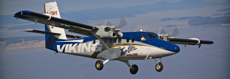
It’s of very limited use in places like Norway, with the weather and terrain we have here. To achieve the advantage you are seeking, to get where you want, when you want to, you would have to step up to something like this:
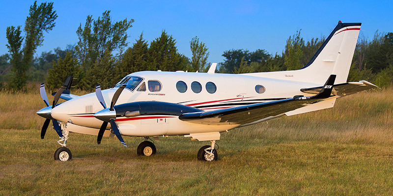
Or this:

or possibly also something like these two:

Also, if you look at that accident I linked to, there were 3 aircraft flying in a group. They flew from ENBO via ENBN to ENVA. Due to different cruising speed, they did not fly together in a formation, but close enough to maintain radio contact. They all knew very well that there was a front coming from SW, starting just south of ENBN. At ENBN, they split up. One flew straight to ENVA, VFR on top. One flew straight to ENVA IFR, because the weather at ENVA was all OK. The last one decided to fly along the coast, straight into the front, flying low level below clouds in poor visibility, for some odd reason we will never know. They were three on board, all pilots, and the PIC had 33 hours of recent IFR training. They had several moving maps, and one IFR GPS (the aircraft was fully IFR equipped). They did not turn back when weather deteriorated, they did not land at ENOL, just a few NM away from the crash site. They did not follow the fjord from ENOL to ENVA (the obvious thing for any VFR pilot in that situation, except perhaps landing at ENOL). They had all the opportunities in the world to get out of that situation alive, starting from very obvious one at ENBN, they could simply follow the other aircraft flying VFR on top straight to ENVA.
I guess with IFR, you also get more aware of the weather situation, so you see more alternatives, and is generally more used to poor weather, thinking clearer, better judgement ? Maybe? I don’t know, because the obvious thing for any experienced VFR pilot in that situation was VFR on top from ENBN to ENVA, or perhaps even easier, lower VFR via ENNM to ENVA, which would also be perfectly possible with huge margins.
It was the term used by the pilot to describe to the journalist from the local paper what forced him so low. It led to some mockery, but I suspect he just meant a droopy overcast, with irregular cloud base.
This was the forecast which would seem incompatible with VFR.
22/02/2015
TAF LFRH 220800Z 2209/2218 15003KT 9999 BKN050 BECMG 2210/2212 21015KT 8000 RA BKN015 TEMPO 2212/2215 20016G28KT 4000 RADZ OVC005
TAF LFRH 220500Z 2206/2215 VRB03KT CAVOK BECMG 2206/2208 15003KT 9999 BKN050 BECMG 2210/2212 21015KT 8000 RA BKN015 TEMPO 2212/2215 20016G28KT 4000 RADZ OVC005
TAF LFRH 221100Z 2212/2221 21015KT 8000 RA BKN015 TEMPO 2212/2215 20016G28KT 4000 RADZ OVC005
TAF LFRH 221400Z 2215/2224 19015KT 8000 RA SCT010 BKN017 TEMPO 2215/2224 20016G30KT 3000 RADZ BR OVC004
METAR (take-off 15h30, 1430Z) :
LFRH 221700Z AUTO 20018KT 1400 R25///// R07/P2000 -DZ BR OVC003 09/09 Q1005
LFRH 221600Z AUTO 19016KT 1900 1300 R25/P2000 R07/P2000 RA BR OVC003 09/08 Q1006
LFRH 221500Z AUTO 19016KT 4100 -RA BR OVC004 08/08 Q1007
LFRH 221400Z AUTO 18014KT 3600 -RA BR BKN005/// OVC010/// ///TCU 08/07 Q1008
simon32 wrote:
nébuleuse thermique
What is that?
Peter wrote:
London Info employ FISOs, not ATCOs, so the charade of “no control” and “we can’t see you on radar” has to be maintained otherwise you are in breach of ICAO and you will get hell from ATC unions.
Langen Information aren’t ATCOs either and have no control, but they do have radar and that’s no secret. What exactly they see depends a lot on how the individual operator has configured their screen. They do have the option, AFAIR, to enable the same level of information as their ATCO colleagues, who sit just a few chairs further.
Descending VFR below an overcast of 800 feet and other improvised letdowns are a recipe for a disaster and even as a IR holder I would not do that.
“Peter wrote:
The above is just for the UK of course. No idea what other countries do if a pilot gets lost or ends up above a solid overcast. Actually the latter is interesting. All normal planes are more stable in roll if you are descending than if you are climbing, but you still need a gyroscopic instrument to do a descent with (the compass method is for very good pilots only who won’t get into that trouble in the first place).
One time coming back from Spain in excellent weather I tuned to Pau ATIS and heard BKN 1500’. Uh-oh, coming over the Pyrenees I saw the whole SW of France covered by a white blanket. Tuning to Pau approach I could hear that there were planes flying below so I looked around for a hole. None to be found so I asked the Pau controler if he could guide me down to the airport. He said he couldn’t due to traffic, but could get me down over the nearby motorway although he was not sure of the ceiling there. I followed his instructions and let down gently for what seemed an age until my wife saw cars with their lights on. The ceiling was around 800’ so I got home OK, but in retrospect I don’t think it was wise, as I had not set my altimeter and failed to check it unwinding.
The controller did inquire if I had sight of the ground so he was reassured at least.
Keeping the wings level on instruments and making shallow turns back to better weather are taught, but tend to be practiced when the situation has gone bad and the outcome is not good. It would be better to instill weather briefing as excellent sources of information are available to anyone with a smartphone, but making the GO/NO-GO decision is not taught so well. Météo France used to have excellent weather briefers, but they have been phased out with the advent of internet-based services.
Most of the VMC-IMC accidents I have read about are from pilots who seemed oblivious to the weather forecast and the fact that the sun goes down at the end of the day.
My translation from a BEA report: last December a pilot took off with a passenger from Chavenay (LFPX) at 15:27 for a flight to Colmar Houssen (LFGA), under a VFR flight plan. After having left the frequency of Chavenay, he contacted Seine flight information service (SIV) at 3:35 pm, approaching Saint-Dizier an hour later. At 16:46, cruising at FL75, the pilot contacted Basel SIV, requesting the latest weather in Colmar Houssen. The controller gave him the 15:00 METAR indicating an overcast at 3,400 ft. The pilot continued his flight and made contact with Strasbourg SIV around 4:59 pm. He then announced that he wanted to start the descent as soon as he could find a break in the overcast. At 17:11, ATC sent him the latest weather from Colmar who reported broken clouds at 3,300 ft and a overcast at 6,800 ft. He told him that it was a little better to the south east of Colmar. The pilot replied that he would turn to the south. At 5:16 pm he left the Strasbourg frequency and recontacted Basel SIV. Three minutes later, the pilot announced that he was in IMC. The plane collided with terrain a few moments later.
Wiser pilots mention that the flight was almost impossible in VFR in view of the weather forecast, the lateness of the departure and the fact that the Vosges rise to >4000’.
Another example last year, an average aeroclub pilot took a friend out to lunch somewhere near Nantes and on the way back was caught in a nébuleuse thermique and successfully landed on a beach. He was hailed as a hero in the local press, but wiser pilots thought he had been a fool to have taken off with the forecast as such.
Family and peer pressures are very strong as this chilling reconstruction by AOPA makes clear:
Simon
My very vague recollection from a visit to London Info is that they hand you over to 121.50 who can plot your position using VDF triangulation very quickly, anywhere in the UK provided you are above a certain altitude, and they will take you over.
London Info employ FISOs, not ATCOs, so the charade of “no control” and “we can’t see you on radar” has to be maintained otherwise you are in breach of ICAO and you will get hell from ATC unions.
What London Control can actually see has varied according to who you ask. On one visit to Swanwick, maybe 7 years ago, they said they can see all squawks (the implication being that they need to pretend they can see only the listening squawk – 1170??).
The above is just for the UK of course. No idea what other countries do if a pilot gets lost or ends up above a solid overcast. Actually the latter is interesting. All normal planes are more stable in roll if you are descending than if you are climbing, but you still need a gyroscopic instrument to do a descent with (the compass method is for very good pilots only who won’t get into that trouble in the first place).
flybymike wrote:
You will never get any “official” vectors from London info
As I said I more had in mind them giving you a hand off to a unit able to provide vectors for a SRA.
flybymike wrote:
I believe however that they do have access to a “traffic monitor”
They have a radar feed on the side of their desk. It isn’t right in front of them but is available for use if needed.
Jan_Olieslagers wrote:
happiness
I think you mean the misspelt “happens” Jan.