nobbi wrote:
and they show the entry arrows for joining the traffic pattern
Just to avoid misunderstandings or confusing Howard – I can’t see this information being included on the VAC charts. Except for a few exceptions where they draw the whole traffic pattern including the downwind (LFPL Lognes comes to mind, see below), you need to figure out yourself where the downwind is, and work from there to arrive at circuit height, rather at the beginning of the downwind leg, from a 45° angle. That is contrary to the German charts, which would always include the downwind leg. That’s why some local jobsworths could imagine the need to follow this line to some imagined degree of precision in the first place…
There is one method that I haven’t used much after my PPL training, but which works nicely to accomplish this. You fly to the overhead at TPA (traffic pattern altitude) +500’, then turn onto the runway heading at the overhead after identifying the active runway with the help of the windsock, fly runway heading (or rather track) for one minute, turn 45° towards the pattern, fly for one minute, turn 180° towards the runway and starting the descent to TPA, and after one more minute you will arrive at the entry point at the correct altitude, with a nice view of any traffic in the pattern. Better to figure out the three headings beforehand though and note them down, so you won’t get confused. 
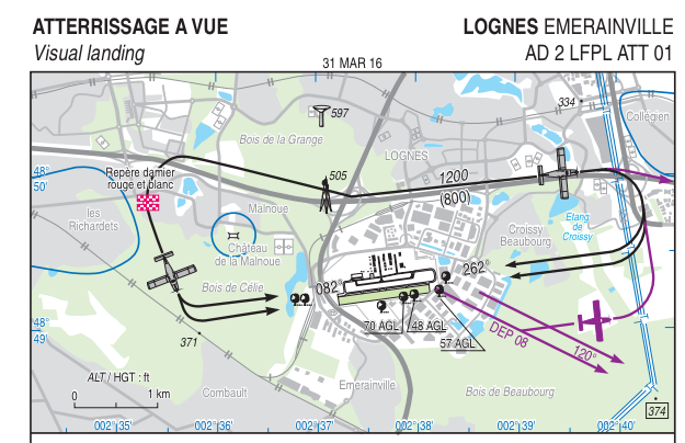
In Lognes, they drew the downwind, for noise abatement purposes:
The “standard French joining” I was taught is overfly the field at pattern +500, look for landing signs and windsock, and join middle of downwind in a descending 270 degree turn that gives you time to look for traffic.
Maybe the French co-forumites can comment whether this is still taught.
My PPL training was entirely in France. The joining is supposed to be done at the beginning of the downwind. Middle of downwind is the US method. How you arrive there is up to you, as long as you don’t endanger other participants in the aerodrome traffic.
Thanks everyone.
I have just bought the Jeppesen plates for Europe on PC (JeppView) because it was easy (no need to register / search each country’s websites), include Germany ( which I understand is not available free online) and relatively cheap. I the circuit patterns shown on Jeppesen agree with the local charts shown above.
Re Munich, I have decided to land at Augsburg (EDMA) and not Oberschleissheim (EXND), (despite Oberschleissheim being closer to Munich) for the following reasons:
Augsburg (EMDA) on the other hand is much bigger so has a phone number and a helpful woman who spoke to me in pretty good English and explained (1) no PPR required – just call up en-route on the radio (2) they have plenty of parking and perhaps some hangarage (3) There is no circuit that she could tell me about, but the VFR charts instead show a number of reporting points which hopefully I can find in the air and which will allow me to safely approach and land. Moreover, because i will be flying down from Bielefeld, I won’t have to file a flight plan (or GAR! :D) so I can just take off from Bielefeld when I am ready and without any clock-watching stress.
My remaining concern is the weather. Augsburg is at an elevation of 1,515 feet, which is 1,515 feet closer to the clouds than might otherwise be the case I guess. Let’s see what the weather brings on Friday.
Many thanks indeed for everyone’s help. I do appreciate it.
Howard
Appropriate decision to go to Augsburg – just got an email from EDNX that they postponed (wx related reasons) their airfield closure due to WIP to Friday 10th. So the airfield Oberschleißheim will be closed anyhow on your day of journey.
Fingers crossed – outlook is better for Friday than for tomorrow (let alone today)
EDMA – the reporting points are not that easy to identify depending on light and prior experience (had some lessons there).
Depending on rwy in use, you might get a straight in, though.
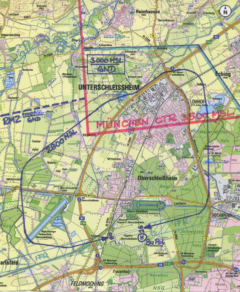
EDNX
Not necessarily more difficult than EDMA – warning is just to make you aware. The 8 lane motorway is not that close, way to the East
The actual shape is interesting, not many fly it with high precision.
From their website:
Anyway, enjoy Munich !
Would be a pleasure to have a beer ;-)
Chris
@ch.ess , yes I saw the map that you show above on the EDNX website but I could not be sure which was the 4-lane road and which the 8-lane road to which they refer! Did the people who prepared the website not realise that without local knowledge (such as the map glossary) it would not be immediately apparent which road was 4 and which 8 lanes wide, especially as the circuit chart shows that the circuit goes into the Munich airspace… but that is what they say to be careful to avoid??
The whole thing is confusing and and it’s this sort of thing that really annoys me i.e. instructions that are so badly written that only those people who already know what is trying to be said can understand them.
I work in a technical field and when I coach young people starting out as trainees, I tell them that I do not want them to write letters and emails and reports that can be understood. They look at me puzzled for a while.
Then I explain that what I want them to write are letters and emails and reports that cannot be misunderstood. There’s a big difference. It’s really important. Our better trainees learn the distinction.
Howard
(Grumpy old man)
Let me respectfully disagree :-)
I found it not too bad.
red CTR from 3500 upward
blue GND to 3000 you are fine
circuit at 2800
B13 is on and visible, just the A8 is missing (OK you would need mr goggle)
I see it, when when I see ;-) SInce you have to be low, you can count the lanes ;-)
Chris
(probably not younger, but not grumpy :-) )
PS Wouldn’t have made it through Northern Italy, had I put the bar on map clarity that high.
Howard, last year I made almost exactly the same flight as you are planning. As a first time visitor to Munich I had the same dilemma in terms of choice of field.I decided to use Augsburg for Customs and then flew on to EDNX (where Flyer 59 kindly picked me up).
The website details overcomplicates it considerably. Unless the viz is really poor, the EDNX runway is unmistakeable from several miles range. And unless flying a B747 circuit the Munich CTR does not get in the way either. There was no other traffic in the circuit, so I simply self positioned for a base leg join. From the apron activity, I don’t think that was at all unusual – very lttle traffic seemed to be the norm. All in all, very straightforward and the airport staff were very welcoming. Not to mention some good beer served at the airport cafe!
Howard wrote:
Augsburg is at an elevation of 1,515 feet, which is 1,515 feet closer to the clouds than might otherwise be the case I guess.It is not, unless the airport is on a hill.