FWIW I think it is a day for not going early. I think it will clag in earlier on and be unpleasant IF the forecast does not change. I also think that as the day progresses the base will lift as convection takes hold with the best window mid afternoon. My comments are based entirely from flying for many years along the coast and living and sailing on the coast. With the current forecast I have seen those conditions on so many occasions when you aseess the weather in the morning and look at the TAFs and based on the TAFs decide it is marginal or not possible to only find that they are conservative by mid afternoon.
In my VFR only days I have crossed a few times at 500 feet the whole way and again in the “right” conditions that is entirely possible BUT it becomes far more important where you are going at each end at what options you have for coastal diversions at each end.
Of course I am not saying take a chance etc etc .. .. make an informed assessment at the time.
yes, but you are IFR ;-) have fun in the alps, should be nice weekend here weatherwise
The current UK MO MSLP charts for Sunday 0000Z and 1200Z are
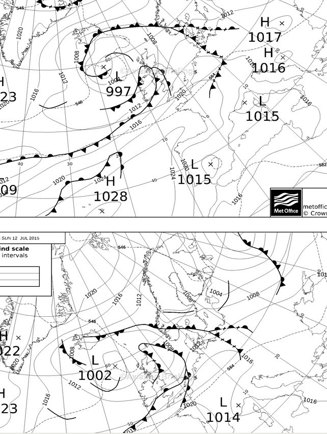
and they suggest that the earlier you depart from the UK, the better.
But this is 3 days out. 3 days is a long time in politics and even longer in weather 
For me, getting back from LOWZ on Sunday to the UK will be more fun
Hi Alan,
im a Fan of this forecast… it says no clouds on Sunday morning ;-) The Met People at the Airport in ZRH are optimistic, have fancy tools. The Met Office UK is not so optimistic, the Gramet is also optimistic… so deciding on majority ? ;-)
Anyway, other question…. for france i know the AZBA chart, so far clear. But how do i find out if other restricted areas are active? If I read the notams for our routing its so quite regarding them… Particularly interested in R 158 A
Regarding cloudbase and % low clouds, there are GFS-derived charts here=
At 72 hrs out, the GFS model starts to become reasonably accurate. I would value any comments regarding the accuracy of the GFS model for low cloud.
Hi,
Sometimes is very hard to plan using just the charts as the weather can change, speed up, slow down, etc for VFR flying.
If you have a smartphone, try downloading a Meteoearth app, I find it very accurate, you can see the actual live radar images of cloud, pressure, rain, forecast, etc.
I use it all the time, its an absolute must for a VFR tourer in my opinion.
Regards,
That’s the boundary layer. GRAMET (or to be precise: GFS) shows a probability of visible moisture there. This part of GFS is not very reliable. If it’s shared it means you should look at the TAFs which provide a more reliable forecast.
Hello,
i did check Gramet and i found it verry interessting, but i can’t find out what the grey layer from EGSX until LFQQ is who is going until the ground (not the clouds!)
Is it what i assume fog?
Sorry for bothering …
Lucas
You won’t get relative certainly until the morning of the flight, and maybe not even then.
Generally one should never cancel a flight on the basis of a forecast, but sometimes, if say carrying a passenger who will get fired if he is not back at work on Monday, one has to. But perfection will never be achieved, and my solution would be to not fly with such passengers – sadly!
Or there needs to be an understanding that they are responsible for buying an airline ticket to get back, if necessary.
Nowadays, when I do a significant trip with my girlfriend (and she won’t do more than 2-3hrs) I always buy her a return ticket.
Lucas,
I find this website useful for looking at the synaptic charts
Clicky here
It allows you to see the charts on one page, so that you can easily see where things are going. Down at the bottom you can see the forecast for the highs and lows (but without the fronts marked).
Watching as things get closer you will see if things are moving in accordance with the forecasts, or if they are changing radically each day.
I suppose the option isn’t open to you, but if it was, getting out on Friday would look like a good plan.
One thing to watch with that page though is that they charts aren’t all updated at the same time. So sometimes you’ll see two charts for the same forecast period, but one has been done 12 hours before the other. So pay attention to the times.