By9468840 wrote:
I am not instrument rated. I somehow assumed instrument approaches help you land when you can not do it VFR but with 3000 AGL decision height
Your comment is highly valid if you know the weather for sure (say you have 3000ft AGL overhead the threshold and 6km visibility), will you still bother flying that AIP approach with 6km visibility trying to spot an 8km runway? I will be better off with a cloud-break by decent
The problem this approach solves is that there is no way to know the weather for sure and getting it wrong with that mountainous terrain is very costly, so you fly that IAP to “test if you have VFR weather, can see the runway while keeping the exit gate open”
The problem it brings is that the weather at MAPt may not be same as the one near the threshold, so on a scenario of 3000ft AGL overhead the threshold and 6km visibility:
- Simple answer: if I can’t see runway at MAPt, I proceed otherwise go missed
- Complicated answer: if I can fly generous VFR from MAPt, I can proceed but if you can’t find the runway you have to backtrack VFR to the MAPt and go missed 
The general Q is valid though, because if e.g. the cloudbase was 6000ft, then I bet (nobody answered my Q above about this) you could fly all the way from Salzburg, through that canyon, end up at the lake and then turn right and just land.
There are loads of IAPs around which deliver little or no value in terms of absolute ability to get in, or not.
This IAP is quite good for decent performance IFR aircraft whose pilot is looking for a structured way to get there and for a structured way to get out if not visual at the MDA. I doubt it does anything that’s actually useful in terms of getting into the airport with a cloudbase of x feet.
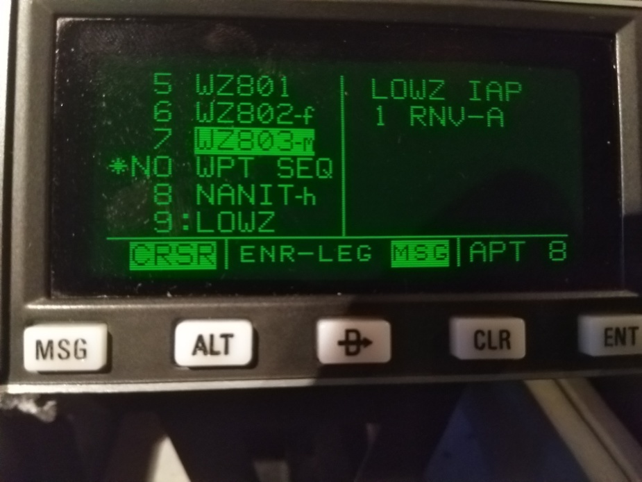
On my old KLN90B there is no sequencing after the Mapt. on this app. How does this look on a G1000? One has to deliberately select the aerodrome to have further guidance in my case…
The RWY08 VFR departure to the East is
Departure via the aerodrome traffic circuit. Not until reaching at least 4000 FT MSL cross over the aerodrome and leave along respectively south of road B311 to the east, but avoid overflying glider area.
If you had to go missed after MApt I would circle up to altitude 5000’ and intercept the 085 track from the MApt.
If the KLN89 does not load the missed approach track, presumably it can be placed in OBS mode and fly 085 from the MApt. The database should show NANIT as the next waypoint in the sequence after the MApt. This should be easy to check.
@ By9468840
This procedure leads you into the valley (!) from a higher flight level through the clouds safely, but doesn’t guide you right down to the runway. I am very critical of these procedures because as practical as they seem at first sight, they tend to lure IR pilots inexperienced in mountain flying into believing a VFR airfield suddenly has an instrument approach. It isn’t. It is a cloud breaking procedure, no less, no more. At 35k €, Austrocontrol defines such a procedure for any airfield. Just look at St Johann, same issue. Narrow turn to final, mountains everywhere, but sure, let’s have an instrument approach where every jock thinks he can fly there in any weather.
f the KLN89 does not load the missed approach track, presumably it can be placed in OBS mode and fly 085 from the MApt. The database should show NANIT as the next waypoint in the sequence after the MApt. This should be easy to check.
I really like this contract set up from AOPA local copy
C172driver summarized it well. One can only guess what went on in the mind of pilot after he passed WZ803.
EuroFlyer wrote:
This procedure leads you into the valley
Considering the width of the valley, couldn’t you descend a fair amount “on your own” and still be within minima?
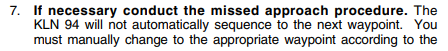
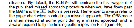
I have never flown a missed approach using the KLN94’s feature, but like the KLN89/90 it works thus:
You do not want to be fiddling around with the OBS mode when surrounded by mountains and pressed for time. I have a checklist for setting that up.
You do not want to be fiddling around with the OBS mode when surrounded by mountains and pressed for time. I have a checklist for setting that up.
Exactly! The buttonology for that is interesting…So I understand on the G1000 the 85 degree missed track relative from the actual position is visible from the map?
Have placed this here because the last section of the video has some relevance to the conversation that has been had in this thread. Feel free to move.
Video is on Bonanza accidents, N reg only, all types, in 2019. 44 in total with some 21 fatalities. Some thought provoking stuff, although no new and novel ways to crash our aircraft.