
One big problem with this sort of thing is that most pilots don’t have a running topo map. So if things go badly wrong they have little idea of where the rocks are. This is what I fly with in the Alps, grabbed from google terrain and running on a tablet which gets the GPS feed from a GPS receiver with a rooftop antenna:
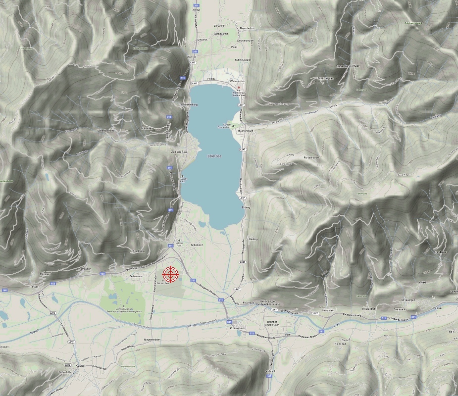
Total database size for the Alps only is about 5GB.
The old Jepp “VFR/GPS” maps, which could run electronically under FliteMap, are much worse
but still the hill is very obvious.
The Swiss ICAO map is even worse

Did this SR22 have SV (synthetic vision) of any kind? Not that that would be much good because you get just a small angle ahead of you.
Re the airport having a say, I don’t agree. They should just stay open, unless impossible to land due to no parking. flooding, etc. I fly every approach even if wx is “obviously” below minima – because a lot of the time one does get correctly visual. This is what the missed approach procedure is for. But would I do it to LOWZ? No. I would not depart on the flight until the webcams showed almost CAVOK all the way up, and same goes for all the other canyon airports (Locarno, Bolzano, etc).
I suspect this pilot had little idea of what he was doing because he seems to have just gone around and flown into a hill. I don’t think he looked at the map before going there. But only locals who knew him will know more.
We know a bit more now, see below for a Google (pretty well) translated piece from here. (ORF is Austrian public broadcaster):
- pilot called airport before departure to inquire about wx
- airport called pilot (!!) to advise of adverse wx
- pilot had landed at LOWZ several times before
- the accident happened after a missed approach / go around
The ORF article:
After a small plane crashed with one dead and two seriously injured children in Bruck an der Großglocknerstrasse (Pinzgau), the Aircraft Accident Commission started the investigation. The airplane had started in Bonn and was traveling to Zell am See.
The 66-year-old pilot, who was killed in the accident, was partly trapped under the plane, according to the emergency services. The two eight and eleven-year-old girls told the helpers that they had spoken to him after the crash. “But they were both in shock,” said Red Cross operations manager Anton Voithofer.
Child was able to free himself from the plane
One child was able to free himself from the wreck, the second had to be cut out of the wreck by the fire department, which was deployed with 44 men, said fire department commander Franz Eder. The injured also told the rescuers that their mother wanted to come by car. The girls were first brought to the hospitals in Zell am See and Schwarzach. In the meantime, the girls have been brought into pediatric surgery at the Salzburg State Hospital (LKH). There one of the children is said to be still in a critical but stable condition. The second girl is on the mend.
Recovery of the plane
ORF / Gerald Gundl
The day after the accident, the fire brigade began to salvage the flight accident commission and began its investigation
The crash site in the middle of the forest in the area of the so-called Erlhofplatte was difficult to reach. In heavy fog and snowfall, the fire brigade had trouble locating the wreck. It took about half an hour for the comrades to locate the scene of the accident with the help of witnesses who had heard the crash. The aircraft was in a depression. The salvage of the wreck began on Sunday morning.
Landing canceled and took off
According to information from the airfield in Zell am See, the pilot had aborted the landing in Zell am See and had taken off again. Then there was an accident. On the part of the airfield, the pilots would have been particularly warned of the difficult flight conditions: “I would not have thought that he would fly to us,” said an employee of the airfield on Sunday, who had been called by the pilot before takeoff on Saturday morning. The weather conditions would have been discussed together. “I then called him again and gave him the data from the flight weather station in Salzburg, which I asked again for him.”
Pilot has often landed in Zell am See
A process that would not have been common in this way. “But it was important to me because he thought he wanted to land with us.” The German was also very considerate in the conversation, so he would have had the impression that he was heading for an airport like Salzburg that was much easier to reach in this weather. As an airfield, you should only report all weather-relevant weather facts. “Whether landing or not, everything is up to the pilot to decide,” said the employee. The pilot also did not land in Zell for the first time. So he should have been familiar with the local conditions.
Sounds like he was indeed going too fast and touched down and took off again.
However, to fly into that hill at that time of the day he had to be in IMC, or nearly so.
No, he didn’t do a T&G, in the original German version it’s clearer and says he aborted the approach and went around.
If he had had SV (even on a tablet) that might have saved him, toy or not. In FF (at lest in the US version, don’t know the EU version), this would have worked well. Not saying one should use this to fly approaches like that, but as get-out-of-jail card it would prob90 have saved the day.
Edit to add: the US FF can also display a topo map, it’s called ‘street map’ in the menu and you can overlay the plate onto that.
An sr22T has sv for sure
What year was this one?
The S/N appears to be 0013.
But these wx conditions wouldn’t get me near any mountain IFR procedure in any SEP, single pilot, with „consumer level“ avionics at all.
Any airfield with such terrain and MDH above 2000 ft is definitely very challenging in any IMC for SEP. I’m sure I wouldn’t even try the approach in SEP and probably I wouldn’t even head to such airport in conditions like that. MEP or SET is different story but no way I would go below/pass MAPt.
I am hoping to see the “top secret” METAR for LOWZ tomorrow, but one interesting aspect would be the OAT. A climb into IMC on the missed will certainly mean icing conditions. I’ve just spent a week “just over the hill” from there…
D-EPRB was fiki certified, IF tks was switched on by the pilot.
@peter
Most Cirrus have a terrain map overlay on the ND. I have never seen a Cirrus without it, going back to G2 models with TAWS and certainly all that are perspective (g1000) equipped.
A topo map is nice if your engine fails in fl170 to turn into some valley before pulling the chute. During a go around in imc in LOWZ I would have a hard time navigating with the excellent terrain map on the ND, let alone something running on a separate device.
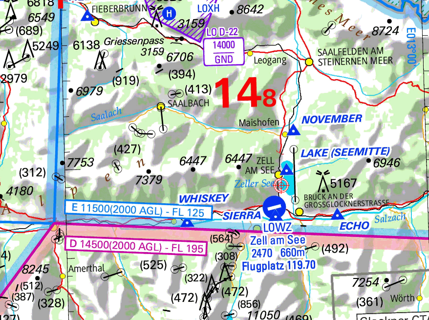
Just a note here: What is the RNP for this approach? Does a cirrus monitor the ANP? To those flying these approaches in hard imc: What is your contingency when RNP capability suddenly decreases?
There is no conventional nav aid to fall back on, so a thorough terrain analysis and escape plan is part of the preflight. That’s where you take a look at the topo map, and brief „in case of rnp decrease, max power, climb to msa via xyz valley“ and that’s where and when you can use terrain data to survive.
The problem isn’t pilots running topo maps or not, it’s the decision making that leads to situations beyond recovery.


