Ibra wrote:
I guess the design track accuracy from MAPt to the end of the missed segment is 1nm that is even way less than +/-0.5 degres, if you are off that track you have to fly very precise headings to get off the hook, I am not sure even if that is practically possible
Ok, now I follow!
You need DWD archive access to get it. This was posted on a German domestic site
REPORT ZELL AM SEE AT 1400 AUTOMATIC WIND 240 DEGREES 3 KNOTS VISIBILITY 6 KILOMETERS LIGHT SNOW OVERCAST 4 HUNDRED FEET TEMPERATURE 1 DEWPOINT MINUS 0
So, wx similar to what was elsewhere in the Alps in that area. Pretty solid IMC at 9000ft+.
Another possibility is he went to go around and didn’t unsuspend by pressing TOGA and was commanded wings level straight into the hill. ie he thought he was flying a GPS missed but wasn’t.
OVERCAST 4 HUNDRED FEET
…which renders that IAP useless.
Having flown to LOWZ a number of times (and living only 45 flight minutes away), this is an airport that needs good preparation and a firm commitment to go elsewhere if conditions are not perfect. After the GNSS/RNAV/RNP approach was introduced I flew it in VMC in a PA28 and the mountains close in on you fast, which is why I refuse to fly it in IMC although I have been asked/urged to “try” and see if we pop out under the clouds. These procedures (and there are a number of them in Austria now – LOJI, LOWZ, LOAN) should not lure pilots into thinking that they’ll get you down to the field. Look at the OCAs and the required climb gradients.
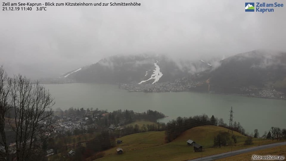
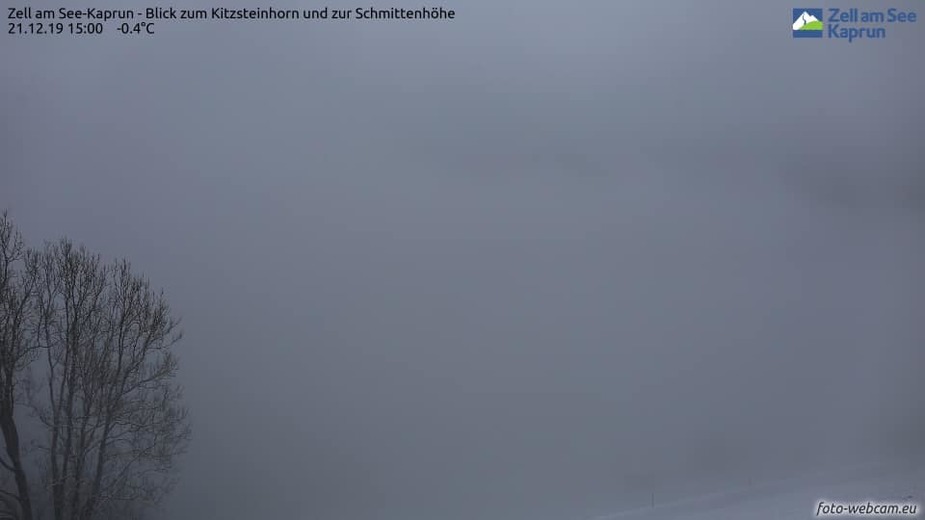
This is where you plan for a missed approach from the beginning and a landing is the exception, not the other way around. The minima are high and looking at the weather on that day it is beyond me why anyone would have even attempted to land in such a unforgiving and difficult environment especially flying single-hand in hard IMC. Below screenshots are from the same mountain looking towards Zell am See and the airfield on the far left side. I hope the older girl makes it through.
PS: I personally talked to one of the pilots there the day after the crash and they couldn’t even get the chopper to help on the S & R because of the weather conditions.
Welcome to EuroGA, d00t, and thank you for your post. I did wonder if anyone captured the LOWZ webcam for the right time.
which renders that IAP useless
Probably so, and in retrospect (we now more or less know it was pretty solid IMC) likewise, but in general this is not the case because a lot of the time the clouds are layered, or there are holes. In 2019, I flew one IAP in what was basically OVC001 or less, tops about 2000ft, solid IMC reported by another aircraft, yet we were visual with the runway from a number of miles back. You could e.g. have SCT001 OVC030 and a plane flying at 2500ft could well see the ground perfectly well, while a ground observer will just see the 100ft cloudbase.
FWIW, here is the Jepp plate
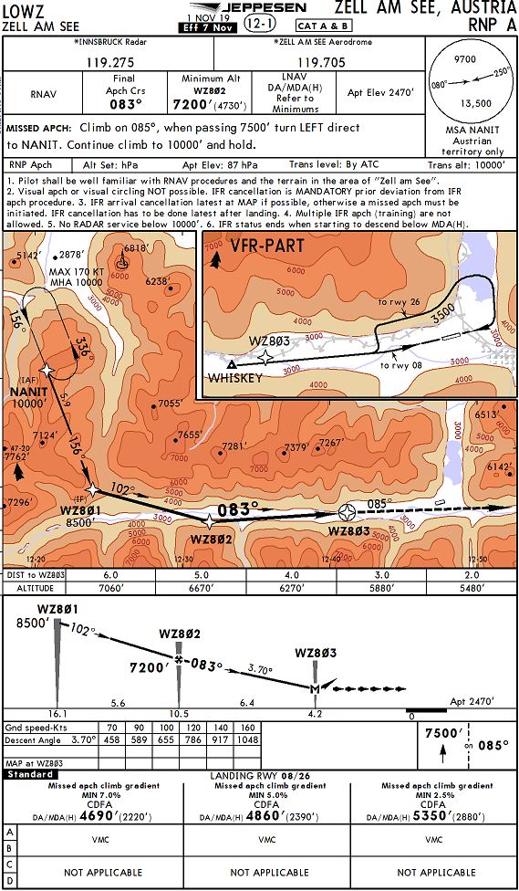
How would one set up the 085 track? Switching to OBS mode is one way, but ideally one would have a waypoint ahead which produces that track.
arj1 wrote:
Am I missing something?
The problem here was most likely not the missed approach procedure itself, but how to get to the missed approach procedure from a balked landing directly overhead the runway – which is something we rarely train!
The situation in Zell is specifically challenging not only because of the mountainous terrain but also because the missed approach does not go straight over the runway.
QUestion to the wisdom of the crowd: Are there any other IFR-Field in Europe, where the MA does not go over the runway?
Peter wrote:
How would one set up the 085 track? Switching to OBS mode is one way, but ideally one would have a waypoint ahead which produces that track.
I expect it would be coded as a track from a fix leg (FM).
Peter wrote:
I would argue that the topo presentation in my post above is absolutely spot on
I guess my main point ist: If you have prepared your Tablett with the top-map (or a SV-Toy, etc.) in a way you could use it effectively in case of such an unusual situation, you are also well prepared for the balked landing in a way that you do not need the top map.
If on the other hand you only start thinking “a top map would be nice” after you got into this difficult situation, you don’t have the time and capacity to set it up before you hit the mountain.
With all the unknowns we still have about the accident: The most likely cause of action is that after the balked landing the pilot found himself in a situation he had not thought about before the approach and had not prepared – with less than a minute lifetime left to figure out a way out…
Peter wrote:
You need DWD archive access to get it. This was posted on a German domestic siteREPORT ZELL AM SEE AT 1400 AUTOMATIC WIND 240 DEGREES 3 KNOTS VISIBILITY 6 KILOMETERS LIGHT SNOW OVERCAST 4 HUNDRED FEET TEMPERATURE 1 DEWPOINT MINUS 0
So, wx similar to what was elsewhere in the Alps in that area. Pretty solid IMC at 9000ft+.
I don’t know where he got this report from, I could not access it anywhere. I will however try to find out what exactly the station is this report is driven from.
What DWD and also Austrocontrol do in some of their bulletins is to take automated stations which are actually intended for Synop observations and translate the format into METAR for aviation use. Possibly the Zell station is one of those. In any case, it is an Automatic observation, which imho says that it has to be taken with a grain (or rather a bucket) of salt.
In my experience as AMO I would take the visibility with a lot of caution. 6 km with light snow and in an overcast of 400 ft is questionable. I’ve personally seen measured visibilities which were much better than the actual observed one. However, in this message, visibility is not the important parameter, but ceiling is.
400 ft overcast is probably measured by a ceilometer or better several. if it is, then it is accurate enough. And it sais enough about the conditions there.