
Airborne_Again wrote:
arj1 wrote:
Too expensive…Sure, but still a step backwards.
Sorry @Airborne_Again, but what are the non-GNSS options (they are talking about the backup soliution) that are not step backwards?
I think NDB is the cheapest backup option.
One problem with the NDB is that you can’t tell if the instrument is receiving a valid signal.
The King boxes park the pointer at 090 if no signal is being received but that’s the only clue, apart from the ident but that only tell you the NDB is switched on and that portion of your receiver is working.
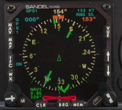
Also it is a bastard to navigate with, because you have to relate the needle to your current heading. An RMI makes it a lot easier but still it is awkward. This is an RMI showing a VOR needle but at least with a VOR you get a flag, and in this case the DME distance (9.9)
With an ADF there is no clue whether it is working, except when it is pointing where you think it should be 
Peter, and the ADF needle points to the nearest storm! :)
I get it, but see no alternative. It’s not like there is an incredibly cheap VOR+DME terminal ground station that costs pennies in CapEx and OpEx.
I don’t even know how complex it is to build for a guy who knows his stuff (and not sure where to find it)
Soviets had this thing where they would place 2 NDBs for each runway threshold, OM & MM, and it was flown with 2 needles, but I think this is an overkill for a backup solution. :)
Airborne_Again wrote:
Aren’t the Norwegian GLSs early trial installations only used by Widerøe?
One of the first in the whole world. No trial, it’s a commercial system. It’s still in operation, but only Widerøe has the equipment, and no one produces it anymore. Very much a dead end today, and all the approaches now has normal GPS approaches in addition (Looks identical to me, but maybe they aren’t? at least the equipment is different).
Widerøe also uses a sequential ground lighting system, following a path with very tight turns towards touch down, often 180+ degree turns. Don’t know if they actually use it anymore, but they are still there. Not “instrument” per se, but used as the last phase to touch down when no ILS can be used due to terrain. Seems to me GPS approaches solves this also (when no ILS can be installed), but don’t know.
Still, there are some backup variant on all airports. ILS, VOR, DME, NDB, LOC or whatever they are all called. It’s only 2 airfields in Norway with GPS exclusively. They are private, and cannot be used for commercial passenger traffic. I think the only use is training (flight schools) and private GA. My understanding from Widerøe and the air force is that it doesn’t matter what the alternative to GPS is, as long as it is something. NDB is as good as ILS in a way, as a back up anyway.
Maybe an FM broadcast station? or pirate radio station if running a cheap NDB…
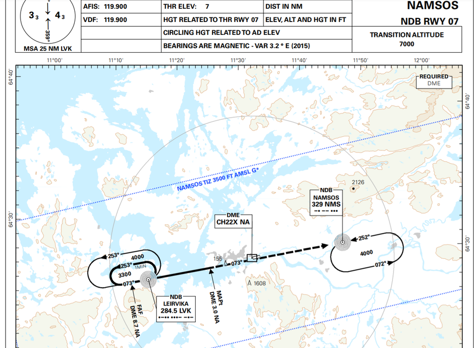
You need DME with an NDB & it has to be close the runway to get meaningful flying, the NDB alone is as useful as flying a single heading on compass and radar altimeter or TwS 
Here is what happens when you fly an airliner with NDB & Rolex, I am sure the twin otters in Scotland are better NDB-cowboys
There will never be a really cheap way to build a VOR. There is too much “stuff” in one, needed to generate the phased array to create the rotating beam.
Then you need – in Europe at least; I believe the US doesn’t do this – a connection to it for a periodic adjustment for the ~0.1deg/year mag variation, and while that is cheap enough (contract SIM cards can be had for €3/month) it is yet more hassle because the supporting system has to be maintained. And you can bet whoever is controlling the present system is going to hang onto whatever jobs are in it.
The best way for us in GA to do a GPS backup is to build a DME/DME based box. It could use a remotely tuned DME like the KN63, and you would need only the one because you would ping one DME and then immediately ping the other(s). You would basically reverse engineer the KDI572/KN63/KX-radio serial interface and just drive the KN63 to tune in nearly beacons. You can get a KN63 on US Ebay for $1k. Uncertified, it would be offered “to homebuilders” and could be built with an output data stream which can be fed (not in compliance with any STC ) to panel mount avionics, or certainly to a tablet satnav app. The KN63 could act as the main DME in your aircraft, and just be switched over to this remote control box if the GPS system stops working.
It would be an interesting project – I reckon 6 months’ full time work – but whether anybody would buy it, I doubt.
Ibra wrote:
You need DME with an NDB
So it seems indeed (I don’t fly IFR). Looked at ENNM which I know has NDB approaches. Seems like DME is required, at least that is what it say.
Peter, ground-based DME is not free either, right?
No, but it will never go away because airliners use DME-DME to do INS fixups enroute.
Ibra wrote:
You need DME with an NDB & it has to be close the runway to get meaningful flying, the NDB alone is as useful as flying a single heading on compass and radar altimeter or TwS
That would depend on the position of the NDB. With the NDB in the OM position, I don’t see much benefit with the addition of a DME in most cases. If the obstacle situation is difficult, you could get lower minima with a DME as it could be used to define step-down fixes and/or for a more precise definition of the MAPt.


