Care to elaborate?
From their website:
MLAT
In some regions with coverage from several FR24-receivers we also calculate positions of non-ADS-B equipped aircraft with the help of Multilateration (MLAT), by using a method known as Time Difference of Arrival (TDOA). By measuring the the time it takes to receive the signal from aircraft with an older ModeS-transponder, it’s possible to calculate the position of these aircraft. Four FR24-receivers or more, receiving signals from the same aircraft, are needed to make MLAT work. MLAT coverage can only be achieved above about 3,000-10,000 feet as the probability that four or more receivers can receive the transponder signal increases with increased altitude.
Multilateration (or MLAT) works by comparing the time difference of arrival of the Mode-S data pulse at multiple receiver stations. A nearby station will receive the pulse sooner than one further away. The timing (along with some complicated maths) can be used to draw a hyperbolic curve of possible positions (a little bit like knowing the radial or QDR from a nav beacon, but not the DME). When multiple measurements are taken over a short period of time, the hyperbolic curves will intersect. As more measurements are taken into consideration a greater degree of accuracy can be achieved.
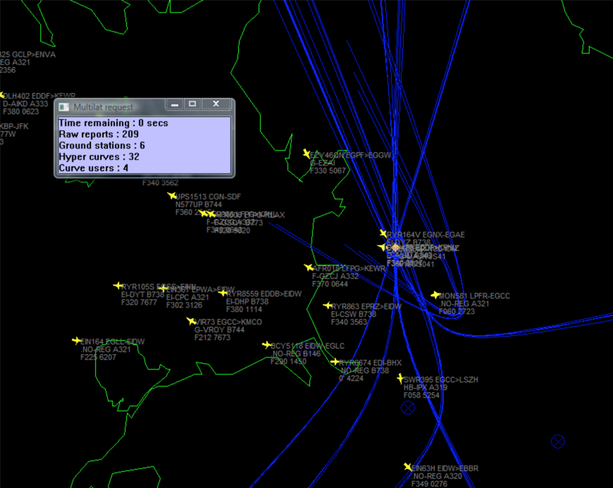
Perhaps a picture will say a thousand words.
The blue lines show 32 hyperbolic curves of possible position, calculated from data received at six ground stations. The intersection of multiple curves is highlighted by a blue circle of probable position and a yellow diamond indicating the likely position of the target aircraft.
Interesting. So this means exact time synchronization is needed for all receivers as well I guess.
@LeSving: Yes, exactly! That’s easy to solve using an internet time server (NTP protocol) <— sorry if that’s stating the obvious.
GPS time is used. The base stations have GPS receivers.
Yes; NTP would not be any good. You need really high resolution timing for triangulation. 1 microsecond is worth 300m and FR24 is a lot more accurate than 300m. I reckon they use something like 10ns resolution.
Incidentally, this portion of my last flight

was done with a 7000 squawk so FR24 doesn’t simply discard 7000 targets. Moreover, while the above is from the FR24 webpage, I get an alert on the (paid) FR24 android app every time I get airborne – usually delayed by about 10 minutes which I think is their policy. This happens on IFR flights too, which depart with 7000 until the handover to London Control.
Just a note to say that FR24’s updated Android and iOS apps now offer much the same functions as the FR24 website – for instance, they can now search for and replay GA flights.
There’s also, until June 30th, a “free” 3-month trial of FR24’s paid (advert-free) services.
Indeed, although it is strange how they have done it. The new app installs alongside the existing one, so you get two very very similar icons. Also there is no way to transfer any config from the old to the new. And if you uninstall the old you lose all its config, obviously. And you do want to uninstall the old one because the new one does all the old functions AFAICT.
The other thing is that the new app is crippled with a limit of 10 on the alerts (aircraft types etc) whereas the old one had no limit. You can expand it with the Gold subscription – what a ripoff.