172driver wrote:
He was high enough, no need to climb and had a wide valley to his right, around 2 o’clock which he should (and easily could!) have flown into
We are theorising that the pilot(s) may have been fixated with climbing in the face of the big mountain ahead, and hence completely obviated the (yes, lower) mountain pass at their 2-o’clock. It is quite apparent that at the crash site they had plenty of altitude to clear the pass.
It is also apparent they had been climbing close to max performance since the last radar track all the way to the crash site , (did someone calculate that?), and had they not initiated such climb they would have had trouble to clear the pass, so they must have had some knowledge of terrain heights along their planned path. If so, at their slow-climb-speed they would have had enough clearance to turn around and head back the way they came or climb further had they not been willing to cross the pass at that altitude for whatever reason.
So @172driver you are right: they had enough altitude to give them quite a few easy options as alternatives to the path that was followed.
There was once when terrain caught me unaware while flying a bit faster than usual and miscalculating how much space I needed to turn away from the mountain ahead. As discussed turn radius is twice larger at 140KTS than at 100KTS. I had plenty of energy (too much) and solved it by climbing (slowing down) and turning at 50 degree- bank vs the usual 30, but it was not nice or desirable.
However, in this case, had they been flying at 140KTAS they would have had zero climb performance, so at least for most of the time from the last FR24 plot to the crash site they would have flying significantly slower than that.
Perhaps they found they had enough clearance for the pass then lowered the nose, sped up then misjudged their turn radius?
Peter wrote:
The problem is that any flap setting reduces your angle of climb. So the improved “picture ahead” is a fallacy.
The object is to see ahead, not to climb as fast as possible. If you are in a situation where you have to climb at max climb against rising terrain, you are already way over your head, and you better turn around and get some alt before trying again. The whole idea is to NOT enter such a situation, or recognize it as soon as possible. I would assume this was obvious, but I was wrong  Still it leaves me wondering why no one “got it”
Nevertheless 1 notch is hardly noticeable performance vise in climb on many planes, but could give you a much better fwd view. Other planes could be opposite, but the only one I can think right now is the Sonex line of aircraft due to the “unorthodox” flaps configuration.
Climbing as fast as possible is of no help if you can’t see where you are going.
I think it was posted and established before: there is a straight-line distance of around 6.5 km from the last radar track up to the crash site: that is about two minutes for a delta of about 1000ft hence 500fpm. Seems that the aircraft was climbing pretty well, so whatever went wrong, it was not aircraft performance.
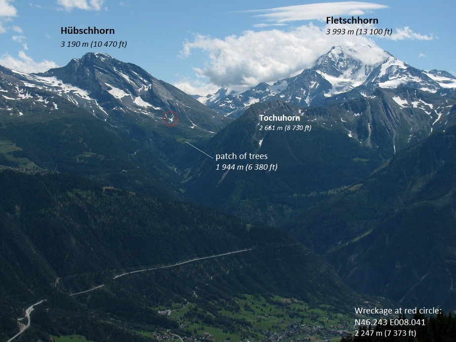
This photo on Flickr (link) shot 20 July 2009 from below Riederhorn, north of Brig, complements the GE screenshot by Raiz in post 376. It looks south to Hübschhorn on the left and Fletschhorn on the right (link). See Swiss terrain viewer if the orientation is unclear (link) or reproduce the view in GE with a marker for the wreckage at the coordinates determined in post 362. For scale the cleared area with a patch of trees is about 300 to 400 metres across. The power distribution cables referred to earlier in this thread cross the valley starting on the left of that patch. That segment crosses about 30 degrees left of the line of sight.
Re foregoing discussion on power distribution cables and pylons. These are visible in high-resolution aerial photographs held in Swiss archives. See link to LUBIS viewer on Swisstopo (link). A colour photograph (link) done 17 Aug 2005 at 0924z shows a segment running southwest on the Hübschhorn side of the main road between the artificial lake Rotelschsee (elevation 2 030 m, 6 660 ft) and the mountain. These cross the road at the western end of the tunnel then cross the valley. The valley segment is clearer in this colour IR (link) done 25 July 1999 at 1008z.
Qalupalik wrote:
This photo on Flickr (link) shot 20 July 2009 from below Riederhorn, north of Brig
That picture was taken by someone standing on Glishhorn or Spitzhorli at 7000ft?
Wind is probably WSW 20kts judging by clouds at FL130
Ibra wrote:
That picture was taken by someone standing on Glishhorn or Spitzhorli at 7000ft?
Wind is probably WSW 20kts judging b
in 2009…..
172driver wrote:
I don’t quite get that climb discussion. He was high enough, no need to climb and had a wide valley to his right, around 2 o’clock which he should (and easily could!) have flown into. A quick look at the map would have confirmed that. Instead he flew straight into a mountain which would prob90 have pretty much filled his window. To me this makes absolutely no sense.
It makes no sense indeed. Either he was incapacitated or he was pre-occupied (with whatever), or he was utterly confused with the situation. It could be a bit of all factors. I still consider a poor fwd vision a factor. Judging the distance when there are no familiar objects, only rock and patches of snow, is impossible. It’s impossible IF you haven’t observed it over a longer time, and even then it is difficult. The only reasonable accurate way to do it, is to fly parallel, so you get the speed sensation. Which is one main reason why eyes outside is all important. A dip down with the nose is of little help. If he was thinking in roughly the same lines as the reactions to my post up here, this only strengthens my believe that this could be important in understanding this accident.
Do you mean a CFIT due to climb pitch angle and not enough forward view?
Is it know in which direction the plane impacted?
Snoopy wrote:
Is it know in which direction the plane impacted?
This might be relevant if he was actually trying to turn back but run out of space. We have been mostly assuming he was flying easterly.
He may have stalled by initiating a sharp turn.
The witnesses seemed to indicate that the plane had fallen and not hit the montane with full force