Another vote for Windy. Old fashioned met office charts help understand what is making the weather, and satellite brings that to life. I’m also finding the auto router gramet is not far off the mark.
Clipperstorch wrote:
Unless we are talking about something different than DWD GAFOR this is not true for Germany.
Oh, great. I did not know that portal nor that the DWD lets that happen. Good. I’ve been trying to get the others to do the same….
Peter wrote:
It presents the European ECMWF model which is the best out there; all this stuff was “top secret” until just a few years ago (because the met offices sell the data to commercial wx data repackagers) forcing GA to brief from the free US GFS model …………. which is not so good for Europe.
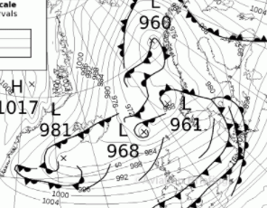
Like a mantra, it is claimed that the ecmwf model is the best. If we look at the picture below, it shows a recent 10-day forecast, ecmwf on the left, gfs on the right. Below is the analysis after 10 days, i.e. for yesterday. The ecmwf had predicted a strong high over the UK with northerly winds over Germany/Poland, the gfs a broad southwesterly flow. The reader may decide for him-/herself which model fits better the flow pattern. It is not (any longer) true to say that the ecmwf is always the better one. In the 1-3 day range, i.e. the important range for the GA, the two models nearly never differ.

In the 1-3 day range, i.e. the important range for the GA, the two models nearly never differ.
At large distance scales ECMWF is calibrated on GFS “boundary conditions” for wind & pressure
ECMWF does not run equation on the whole earth surface just build on top of similar GFS outputs with more “European ad-hoc add-on” or local runs, it’s on local European weather where it shines as it has better terrain, average for many snapshots & locations ECMWF will look like GFS, on a single small location & snapshot, ECMWF is likely to be more accurate but predictions are instable at every recalibration & updates…
A bit like comparing your instantaneous GPS ground speed to to ground speed for old fashion navigation
It’s hard to compare models when the time stamp for update is different and inputs are different even GFS at 11am may differ from GFS run at 12am due to “new data”, so comparing 6am ECMWF to 11am GFS at 1pm is none sens but it works on average 
It is not (any longer) true to say that the ecmwf is always the better one
Has anyone said “always”? That’s obviously impossible. To give an extreme example, if you stuck 20 MSLP charts around the edge of a bucket and floated a rubber duck in there, and looked at the chart which it points at when it settles, eventually it will give a totally accurate forecast  So then people will post on forums that a rubber duck is the most reliable wx forecaster.
ECMWF clearly stands out as the most accurate for GA flying, GFS less good, ICON total crap, GFS-derived gramets mostly crap in depicting IMC, ICON-derived gramets crap… but often ECMWF isn’t right. One could also say ECMWF is the best because it is available for free.
And many conditions are impossible to forecast, and a part of the skill of “understanding wx” is that a lot of scenarios will almost never be accurately forecast. For example forecasting any detail in this
is a complete waste of time. Flying in that wx will work if you have decent hardware with radar and ice and lightning protection (which is why airlines have such a great despatch rate and a great safety record; they can just drill a hole right through that, and it isn’t because they are flown by PhD-level atmospheric physicists who passed 13 exams) otherwise stay at home, or do a very short local.
Has anyone mentioned GRAMET ? I use a combination of Windy and Autorouter GRAMET, plus due diligence on Sig wx charts etc. I get most of this via the briefing pack in Garmin Pilot (with the exception of Windy of course).
NeilC wrote:
Has anyone mentioned GRAMET ? I use a combination of Windy and Autorouter GRAMET, plus due diligence on Sig wx charts etc. I get most of this via the briefing pack in Garmin Pilot (with the exception of Windy of course).
Tried. Does not always show the correct picture (to put it mildly) as compared with other source.
Quite often I see one thing on Windy + GRAMET and a different one in METARs (military aerodromes often use AUTO, so show all the cloud layers).
NeilC wrote:
Has anyone mentioned GRAMET ?
Sometimes it gives correct picture, sometimes not. Yesterday in Croatia depicted icing from mainland to coastline from 5000 to 11000 feet but in reality it was layered clouds with practically no icing at all or very light in some clouds.
With the release of Windy (which I hope you all support by paying for the premium account) I don’t use it as frequently as I used to, but can still give my vote to meteo.pl, it doesn’t cover all of Europe though. Their model was often solid, and I still use it from time to time in addition to Windy.
Yesterday in Croatia depicted icing from mainland to coastline from 5000 to 11000 feet but in reality it was layered clouds with practically no icing at all or very light in some clouds.
Was that with GFS? or ICON? I think AutoRouter does let you compare ANOA GFS and DWD ICON both are not very good compared to ECMWF for predicting layered cloud amount or cover
Now even if all agree and predict solid stratus layer, AutoRouter will systematically predict icing at -7deg in solid overcast stratus even if there is no water on it, what was the OAT between 5kft & 11kft?
AutoRouter Stratus Icing = layered cover * layered index, where index = -t*(t+14)
I think in convective icing, AutoRouter does things better (as it looks at vertical profile of vapour amount in clouds and some icing & weather dynamics) but for layered icing it’s way off to to be useful: the formula is not even mathematically sound nor incorporate any icing dynamic: it does not say much other than “don’t fly in stratus bellow 0C, especially at -7C” !