It should be easy to have e.g. SkyDemon, Foreflight measure your take-off performance.
Hit a ‘start’ button before brake release, work out the distance to the point where you altitude increases at a rate that must mean flight, and distances to 50ft/100ft above the lift-off point, etc.
Do any packages do this? The data you could gather on what you personally manage to achieve in the real world might be very useful.
You can achieve this pretty easily by just exporting your breadcrumbs into Google Earth.
GE can measure a line distance. So just look to see where your altitude started to increase.
The sampling rate of most moving map breadcrumbs is probably too slow to give meaningful results for typical GA take off duration of 5 to 10 seconds.
Perhaps the easiest is for a bystander with a video camera to record ground roll time and distance.
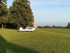
For example, we see this short-wing Maule lifting into ground effect in 11 seconds (about twice as long as it would take without half a ton of ASK 13 in tow). 
Oziexplorer (the generic GPS moving map app I’ve been using since 2001) can be set up for any logging frequency, and I reckon there are others. Even some ski app would do…
The GPS chip itself is slow. I think max 1 Hz. It used to be 0.2 Hz for older ones. Or perhaps it is improved? You certainly could log it faster, but that wouldn’t help. Several glass panels have logging capabilities and include AHRS and air data. That will greatly improve stuff.
I am planning to fly a Lance II (the t-tail one) from shortish strips this season, and for this I am planning a couple of take-off distance checks tomorrow, with a forward CoG, which is notoriously interesting for that type.
In my experience, GPS is not good at identifying the point of lift-off, although a WAAS one should give the distance to 50 ft height with fair precision. An observer preferably with a camera is necessary for a good estimate of ground run. And you need the wind at the time of take-off to get anything really useful from the distance measurements.
Also, you don’t really know the precision you are getting without doing it several times and see how well you can reproduce the numbers.
LeSving wrote:
Several glass panels have logging capabilities and include AHRS and air data.
Yep. Even my “low cost basic” dual G5 panel allowed me to perform, record, and plot the flight test data that was required for a MTOM increase on my steed 2 years ago. Loads of extractable data, such as accelerations, pitch/bank/yaw, speeds, etc.
Having seen aviation pass from steam to digital has been a mesmerising experience 
LeSving wrote:
The GPS chip itself is slow. I think max 1 Hz. It used to be 0.2 Hz for older ones. O
Lots of modern chipsets do 10 Hz updates.
I’ve built a tool to scorecard all my flights, and finding the point of take off, to measure take off roll and initial climb performance, is surprisingly difficult because… runways are not flat. So I focused on distance to 50 feet instead, which is a bit easier, and afaik is part of every poh so an easy comparison point.
Yes if your GPS chip and breadcrumbs software was sampling 10 times a second that would probably be sufficient for good info.
You’d certainly then be able to check altitude against time for a rate of increase that is too great to be an upslope or undulation and must mean lift off. Probably wouldn’t work for departures where you hold it in ground effect to build speed.