I started to use garmin pilot and also have been using SD for IFR for years. VFR for sure SD is the best. What is a pain that for France SD does not generate geo referenced IFR APP plates. This is much more consistent better in Garmin Pilot. Also if you need to load another approach in GP this goes more easy. For IFR GP is a bit better structured. If you fly a SID STAR you better read also the AD section in the AIP ;-). GP and SD have that option to read or download that section.
I started to use GP because i can use autorouter and GP seamlessly and upload it over the Garmin connext to the navigator through my smartphone. The GP route generator and autorouter are basically the same I would say the autorouter interface is better to generate a route….
boscomantico wrote:
a few other nitty gritty details, which, if undiscovered, could theoretically cost you your life one day
Like DME referred by channel rather than frequency when not colocated with VOR/ILS. Then you suddenly have to pull out translation of DME X/Y channels to actual frequency in order to set proper one.
Having calculated the minimum you can check with world wide jepp charts provided with navigraph flight simulator add on it costs about £100 per annum for all jepp plates for flight simulator they are updated with airac
Vref wrote:
What is a pain that for France SD does not generate geo referenced IFR APP plates.
Indeed. A combination of the decision by France to not upload plates separately to EAD and the decision by SD to handle the downloads automatically.
Emir wrote:
Like DME referred by channel rather than frequency when not colocated with VOR/ILS. Then you suddenly have to pull out translation of DME X/Y channels to actual frequency in order to set proper one.
Any decent IFR navigator should have the frequency in its database (The GTN650Xi certainly does.)
Any decent IFR navigator should have the frequency in its database (The GTN650Xi certainly does.)
I agree but we’re discussing plates.
I have been given enroute waypoints that couldn’t be located in SD.
I alwas have SD running. But navigation primary, is the panel and Garmin Pilot. I actually do everything in GP which updates the panel, which simplifies everything greatly. I leave SD in VFR mode for a contrasting view which for me helps situational awareness and in the UK if you get an IFR dump, it’s no big deal in terms of immediate info, just a pain to be dumped.
Emir wrote:
I agree but we’re discussing plates.
I know. My point was that you don’t need to carry a translation table.
GA_Pete wrote:
I have been given enroute waypoints that couldn’t be located in SD.
That’s interesting. Are you sure they were not terminal waypoint that ATC happened to use enroute?
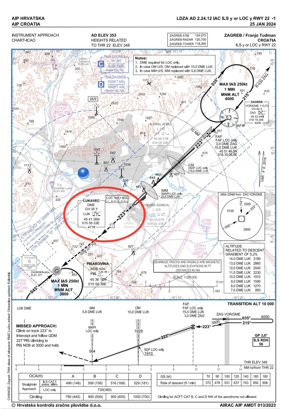
Airborne_Again wrote:
I know. My point was that you don’t need to carry a translation table.
That’s absolutely true if you have any navigator with current database. However, I always wander who decided that it’s great idea to omit DME frequency from chart below (and from other Croatian AIP plates where DME is not colocated with VOR e.g. LSJ DME at LDLO), especially where this DME is primary navaid to check distance in localizer approach.