dublinpilot wrote:
f you’d like a trial of EasyVFR
I think we should talk in Croatia  – if you come
Roger! I’ll be there as a result of Peter’s kindness in offering me a lift 
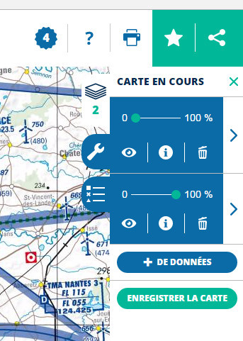
@Peter, for some reason, the satellite photo layer is placed on top of the ICAO chart. Turn it off in the right pane: click on “<” to the left of “CARTE OACI-VFR 2016”, then the cogwheel to the right of the satellite image thumbnail, then the eye icon (or the bin). Here you go!
I did it by setting the opacity of the sat layer to zero
What a bizzare site!
Duh, indeed new isn’t always better…
I started this thread to get an overview of ICAO charts of European countries available for free so feel free to contribute.
I’ll start with what I know is available for Switzerland. In the web browser you can get it from the official site here or in the app store for iOS here. The latter is the official map of Switzerland but in the settings you can switch to aeronautical mapping and also get the restriction area map for drone flying.
And then there is of course Openflightmaps.org but that is not ICAO…
The challenge is to download the map tiles from these sites and combine them into a single graphic file, so it can be run offline, as a GPS moving map. You may safely assume it has been done but not by anybody who posted about it on EuroGA
And the ICAO Map viewer mentioned in this thread