
An AIC is found here. The English translation of the text is of painful quality, but that’s not the point here.
Basically, they have understood that their TMA design in the past was crap. They had what they called “VFR sectors” in their class A TMAs (Milan and Rome); something that nobody really understood.
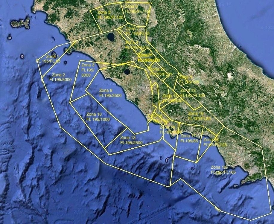
The Rome TMA has already been redesigned, the other three will follow soon.
In summary:
- there will be no substantial changes, i.e.: the TMAs of Rome and Milan will remain class A and thus a huge obstacle to VFR
- they will adopt a more standard TMA design, i.e. a collection of TMA sectors with different lower limits; below the lower limit, you will be below the TMA, above the upper limit you will be above the TMA (sounds funny, but this was not the case so far)
- all lower limits of the TMA will in future be defined as “xxxx feet MSL” (or “FLxxx”). No more definitions based on AGL, which is a big improvement. On the other hand, this will lead to a higher number of sectors, making things more complicated again.
Some first notes on the new Roma TMA:
- they managed to create the astonishing number of 21 (twentyone!) different TMA sectors!
- there are still many sectors with very low lower limits and these sectors are still quite vast. This means that VFR pilots will still be forced to fly quite low, even when quite far away from the primary airports. This is a huge chance lost and a big disappointment
- however, here and there, things have improved a bit. For example, when flying from Olbia to the mainland near the Orbetello (many miles away from Rome) one used to be restricted to 2500 feet MSL over the sea. Now, one will be able to fly up to FL85.
- the overall lateral size of the TMA has reduced a little bit, particularly in the north. The Isle of Elba is no longer “covered” by the TMA.
Lessons learned: don’t buy paper charts for Italy. They often make huge changes to the airspace structure whenever they want, making paper charts (published once year) totally useless.
To be seen: how will the Milan TMA turn out? In particular, will there be more “space” to play with for VFR pilots crossing the Alps southbound, i.e.: more time to descend at reasonable RODs? Given the result with the Roma TMA, it doubt it.
Here is a graphic of the new Rome TMA. As said, not a lot has changed. Still a massive obstable to VFR flying…
Looking at Zone 10 for example, how many transport jets are going to be1500ft amsl out there?
I was thinking the same. Especially when zone 8 is down to only 3500’. And what is the point of all those funny-shaped little zones to the north-east?
Zone 14 and the little rectangular Zone 15 appear to be associated with Latina, a joint use airport where the Air Force does basic training. Those connect to Zones 13, 10 and 3 which have lower floors than Zone 8 in the middle, which they surround. Maybe the Air Force wants their own space for low level aerobatics.
It looks like a bunch of lines thrown down at random on a map.
A missed chance I’d say. If Milan goes the same way…. then not much has changed really for VFR.
And yes, what is the idea with this 1000 ft thing over the sea? Right over the airport you get 3000 ft and there, where it is really dangerous to fly this low for any SEP and VFR in murky conditions, they still force everyone down to 1000 ft?
Well, I’ll save Italy till I have my IR back. Much safer.
The reason why zone 8 has a higher base is that this is where the CTR sits (which has a eiling of. 3500 feet).
Zone 10 really seems excessive. Looks like that’s at least 15 miles from the airport.
As I said in the opening post, much of the complexity in the inland part is a consequence of changing from AGL defined to MSL defined bases of the CAS. When you use AGL, you can have a single sector cover big areas, even if they are mountainous. When use you MSL, then potentially you have to make many many small sectors, all of them taking into consideration the terrain. The alternative would have been to make a more crude sectorization, but that would have “wasted” even more airspace.
It’s still a good move to change to MSL, but one has to live with the added complexity of the chart.


