Peter wrote:
I reckon they already have the tops, to within say 1000ft.
They do have the tops, but only for the actual weather, not as a forecast.
In Germany you can always call the weather service, and ask for the weather for a specific route. Don’t know if thats available elsewhere as well.
Peter wrote:
But there is no current website which applies the real (ok; ex-GFS-forecast) temp profile to the EUMETSAT images. There’s a nice project!
I sent them an e-mail with two questions, one about how they determine cloud tops, and the other about the influence and differences to GFS. I now received these answers (my translation):
About cloud tops
- First of all, we analyse where there are clouds and of what kind they are. This is not trivial. Thin Cirrus for example falsifies the temperature signal and it would only output nonsense.
- The temperature also has to be determined with a lot of effort. Information about this is available from several spectral channels which have to be calibrated/modified due to CO2.
- The temperature is then compared to the one according to our model run at the respective hour and the altitude in the model is determined.
- These then have to be converted to flight levels, i.e. height above 1013,25 hPa in the ISA, since altimeters are calibrated to this.
About our model chain
- GFS initializes our regional model (European model)
- We run our own regional model with differing physics, differing resolution, different numerics and varying emphasis on calibrations of the parameterisations. So it’s a model that is fundamentally different from GFS.
- Since this is not sufficient for our services, we also run a convection model with very fine resolution which is run at the end of the model chain.
So it’s much more than just a reconditioning of GFS.
Peter wrote:
Let’s take a more difficult scenario. No fronts forecast at all on this route. Take Salamanca LESA to Split LDSP, Saturday 6th August 12Z
That’s more difficult especially because there is no chart cut that contains the whole route, short of the one for the whole of Europe.
Already I entered the route in Skydemon and wouldn’t want to fly it in a straight line, too much water. I would try something roughly like this:

Difficult points can be the Pyrenees and the marine overflight parts.
As always, let’s start with the potential VFR hours:

Don’t see a problem already, maybe in Italy I’ll have to deviate a bit to the north.
Significant weather looks good, maybe some convective activity in Italy. Again, maybe need to deviate north.
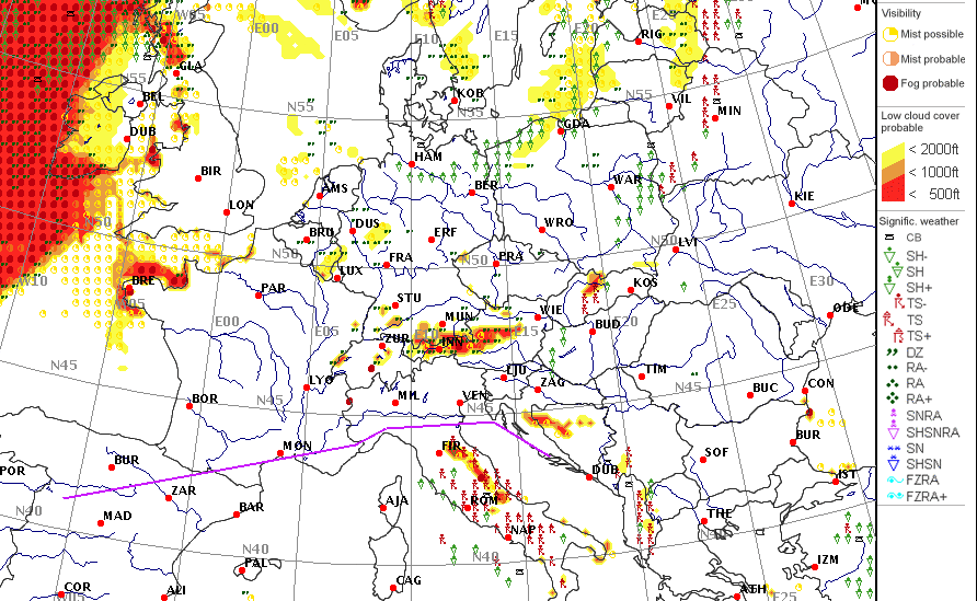
Clouds look fine. Nothing but blue skies!

Weather at destination:
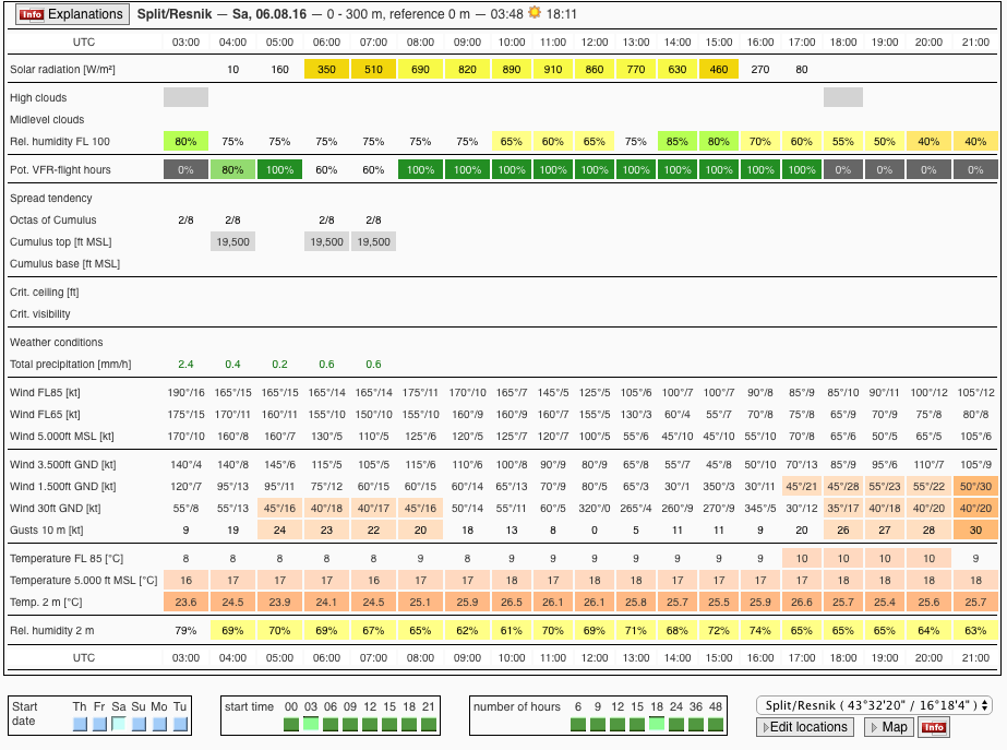
So maybe for reasons of wind, I want to arrive between 08Z and 16Z.
Where is the “gotcha”?
There is no gotcha 
I was hoping that maybe there will be some low stratus or fog along that route which will show that there are limitations to these forecasts. Let’s take a look at the tafs and metars on Saturday.
Normally, in southern Europe, a nice clean high pressure on the MSLP does mean blue skies, more or less. In northern Europe you can get other stuff (which GFS may not show at all) and in the winter you can get low stratus (e.g. base 700ft, really bad vis below, tops 2000ft) which GFS will not show at all.
On your post before that… this bit

does suggest they again are not correcting the IR image temperature for anything like actual temps aloft, but are using the ISA rate. Just like the SAT24 site which also presents EUMETSAT with cloud tops corrected for ISA only

So if say (summer) you have ISA+10 that means the clouds will be 5000ft higher than they say. The other day I saw ISA+15, which is fairly common, and sure enough not only I only just managed to get on top of what should have been easy but the plane would not climb above FL175 or so. In ISA-15 it would do something like FL220-230.
I am no wx forecaster. I did the IR Met exam by doing the computer one on an Ipad 35 times… I just know how to press buttons on wx websites, and I have done quite a lot of that
Peter wrote:
this bit … does suggest they again are not correcting the IR image temperature for anything like actual temps aloft, but are using the ISA rate. Just like the SAT24 site which also presents EUMETSAT with cloud tops corrected for ISA only
That is not how I read it. This step comes last, but step 3 already takes care of the actual temperature aloft (as predicted by their model, not as measured – but better than just taking ISA).
3. The temperature is then compared to the one according to our model run at the respective hour and the altitude in the model is determined.
Actually there was one sentence in the e-mail I received which I didn’t translate, because it seemed obvious to me from reading points 1 to 4. It says:
We think that using only the standard atmosphere for correlating the temperatures is unjustifiable from a scientific as well as an aeronautical point of view
That sounds really good then! I will check out the subscription costs.
Peter wrote:
Let’s take a look at the tafs and metars on Saturday.
Here are the forecast blue skies, and the forecast wind around the adriatic sea, and the little convective tendency in Italy:

Almost no cloud, except some high cloud over Croatia:

OK; let’s try it for the UK next time
The “problem” with Spain etc is that a simple high pressure is usually CAVOK.