
In the case of Mönchengladbach the terrain shown on my 795 is always away to the right of track. In the same vein, returning to Lelystad EHLE from the east I always get a warning – and the terrain here is as flat as the proverbial pancake 
Peter wrote:
The certified TAWS products are believed to contain more aircraft performance specific stuff, so as to more intelligently disable warnings on procedures.
About the performance I am not so sure. The EGPWS boxes come in different "Mark"s for different categories of aircraft (https://aerospace.honeywell.com/en/pages/enhanced-ground-proximity-warning-system) but apart from that I don’t think they are aircraft specific. Especially as the performance of the aircraft will vary greatly (by a factor of at least 2 for a light jet!) with load and temperature, both of which are not known to the GPWS.
Peter wrote:
It would be a brave person to ignore a TAWS warning in IMC,…
Strictly speaking, with certified TAWS, warnings are just warnings (“CAUTION TERRAIN!”). One does not have to react to those other than wake up and have a look at the screen which will automatically display terrain data, even it it had been deselected. But the command “PULL UP!” must be followed instantly. Opinions (and SOPs of different companies) vary if that is also the case when one has visual contact.
LFHNflightstudent wrote:
It shouldn’t really get to that point though should it. Not sure what terrain warning you would be getting – but I assume what you mean it says is indeed terrain, (not an obstacle/antenna for example in which case in most SEP’s you wouldn’t be getting that warning – not sure about more advanced aircraft) which by definition doesn’t move. So for argument sake – let’s say you are in a single engine plane – you should know from the Jepp charts at what altitude you ought to be by then.
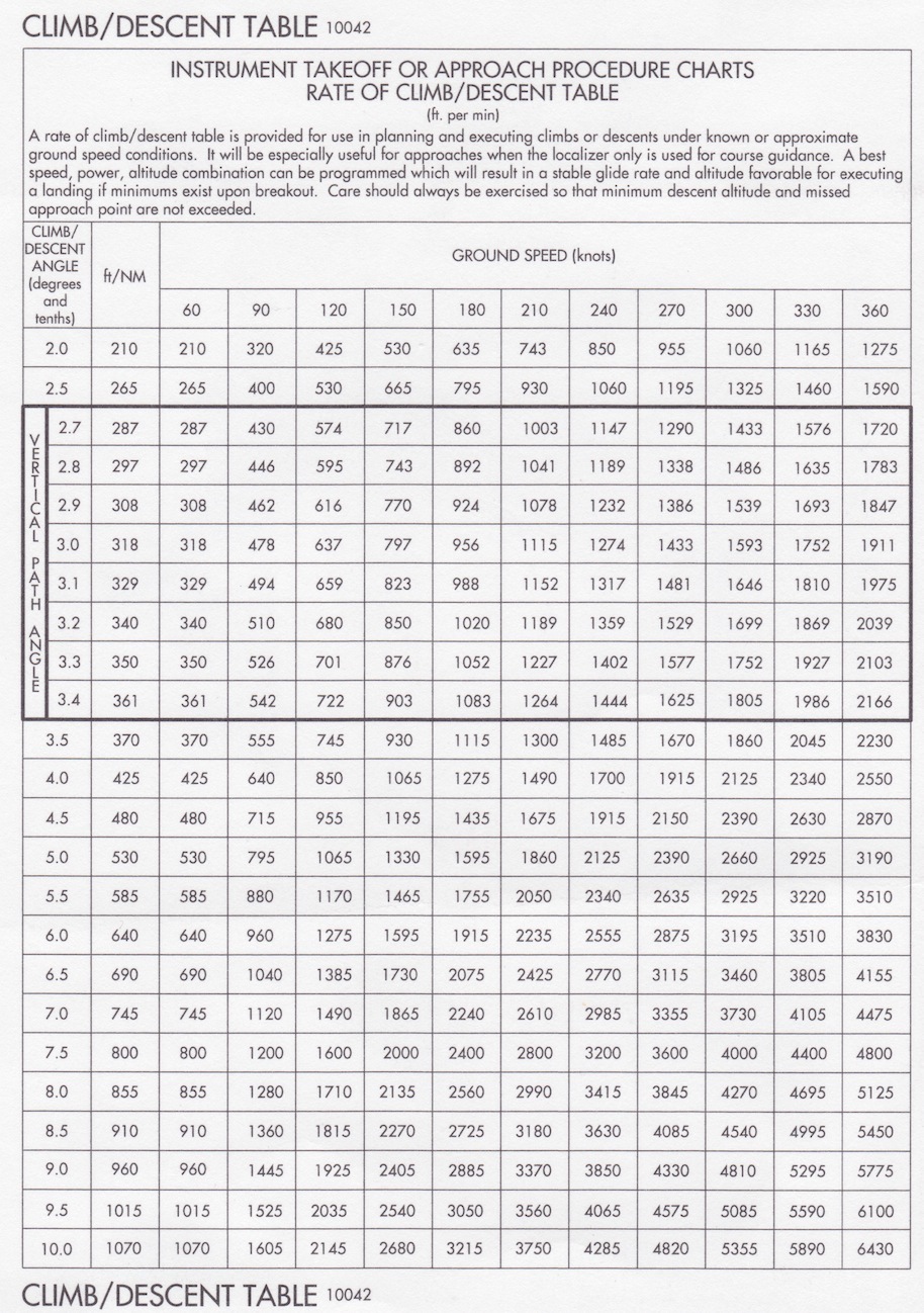
The situation that prompted my question was a climbout at Henderson (Las Vegas) KHND after taking off to the south from runway 17R. I don’t remember if we were given the SID. But on that chart, you can read the following note: “TAKEOFF MINIMUMS – Rwy 17R: Standard with minimum climb of 560’ per NM to 5000.”

According to this climb gradient table, assuming 120 kts which is a normal cruise climb in an SR22TN, that equates to a required vertical speed of about 1100 fpm (no wind):
Maximum rate of climb speed at MTOM is 101 kts at sea level (96 kts at 10’000 ft), which is what all the tables in the POH take into account:

We got an “obstacle ahead” alert from the plane’s TAWS at one point, which is kind of scary at night. The only action taken was to decrease the speed for a better climb angle. The warning then went away. ATC didn’t say anything, which I have also seen differently where they would inquire if you’re VMC and have the terrain in sight almost at the same moment where a terrain warning from the plane pops up – even when you are on VFR flight following.
Afterwards I looked at the trace in Google Earth, and it didn’t look awfully close to the terrain. But it got me thinking.
rwy20: One shouldn’t really take it into consideration, BUT: SIDs are calculated on a worst case takeoff assumption, i.e. passing the runway end at 50 feet AGL. In most piston singles, particularly an SR22, one will usually pass the runway end of most instrument runways at closer to 1000 feet AGL. This gives you a good head start and reduces the required climb rate considerably in most cases.
@Caba, thanks, and it’s a great service around Cologne.
Caba wrote:
But here comes the real irony:A0846/17 NOTAMN
Q) EDGG/QPACH/I /NBO/A /000/999/5052N00709E005
A) EDDK B) 1703020000 C) 1705212359 EST
E) DUE TO OUTAGE OF NVO DVORTAC THE FLW CHANGES TO STAR OCCUR:AMEND NVO DVORTAC TO READ NVO INT. PSN REMAINS UNCHANGED.
That’s hilarious!
Regarding the NORxP SID as an alternative: It´s only longer on paper, in real life we usually turn prop aircraft direct out of 4000ft, jets out of 6000ft.
Indeed you do, so I normally ask for the NORxP and prompt for direct when passing 4000, and it works very nicely. However, the time I flew the NORxF was a day when a glider area was active and I was told the NORxP wasn’t available. The alternative was the left-turning NOR departure, I forget the letter, but it looked like it involved a trip to Berlin and back with a different departure sector. So I was motivated to do the math and flog the engines a bit. Besides, 1000 feet per mile in a PA30 is kinda fun. :)
.
bookworm wrote:
Besides, 1000 feet per mile in a PA30 is kinda fun.
Not for the Pa30.
Aviathor wrote:
So although the margin would not be great, I would make 6000’ before OHR.
That particular departure has the advantage that if you’re uncertain of the climb gradient or it turns out you can’t cross OHR at 6000+, you could ask ATC for an additional “figure 8” around OHR.
I had a long conversation with ATC prior to the intended departure and did ask him whether it was an option. His answer was “no”. But clearly, if push came to shove…
To answer the earlier question, here is the data

but the CHTs may go quite high if you climb like that.
What I always wondered about some of these POH climb performance tables: do they really mean “Mixture: FULL RICH” for the entire climb profile?
It is obvious that these values are only attainable with a properly leaned mixture. But why don’t they write so properly under “Conditions”?
Same for climb speed: those 95 knots only work down low. Higher up, Vy reduces. Why don’t they write so? One can’t make a POH table which is supposed to be valid for entire climb profile, yet under “Conditions” indicate only the starting conditions at MSL…
Silly POHs…


