The Eastbourne air show in on mid August. There is likely to be a prohibited zone for the whole week.
My post #12 was something much smaller…
I called Brize and Farnborough about some of the restrictions as some of them have a component where is says if you are in receipt of a service then entry is possible.
The controllers were very relaxed and very helpful.
Went something like…
I’m trying to work out the best times to avoid but my flight is close to ending and starting times. If it doesn’t work out perfectly for me I’m going to be looking for an entry clearance. How likely is it that I’m actually going to get that……
Reply…..should be fine sir, we’re not actually too busy today and we’ve got everything on radar with enough space to keep everything moving. Give us an early call and you probably be right through.
How’d it go?
Easy peasy.
Here is another – a Belgian pilot got a £5000 fine for this one some years ago
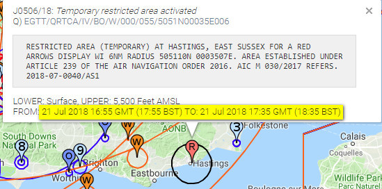
This time it is for just a short part of one day. On previous occassions the area was closed for several days, IIRC.
Private pilots will plot the points and draw them on their paper charts, because that’s part of flying, that’s what we all do and no-one uses electronic navigation aids or sources of information.
If putting sarcasm on the internet, it is necessary to make it very obvious and you did that correctly 
I’d add one thing:
Commercial pilots don’t worry about it as their ops department takes care of it.
Actually they fly almost totally in CAS and most of these RAs are OCAS. Also they fly under ATC control and when flying thus, ATC keep you away from anything active. This is why enroute notams are almost never looked at for such flights – one of the advantages of having an IR
Probably because in the CAA’s world:
Commercial pilots don’t worry about it as their ops department takes care of it.
Military pilots don’t worry about it because enlisted men and women take care of it.
Private pilots will plot the points and draw them on their paper charts, because that’s part of flying, that’s what we all do and no-one uses electronic navigation aids or sources of information.
Yes that is exactly the wheel which everyone has reinvented separately
The problem is there is no standard format and it needs to be done manually.
Obviously SD will do it for the UK watering hole runs.
It is a very unsatisfactory situation but as long as the legal obligations are discharged by the publication of the coordinates in a pdf, why should they change?
Peter wrote:
I wonder if they do that for every country and every object thus notamed?There is no obvious automated process.
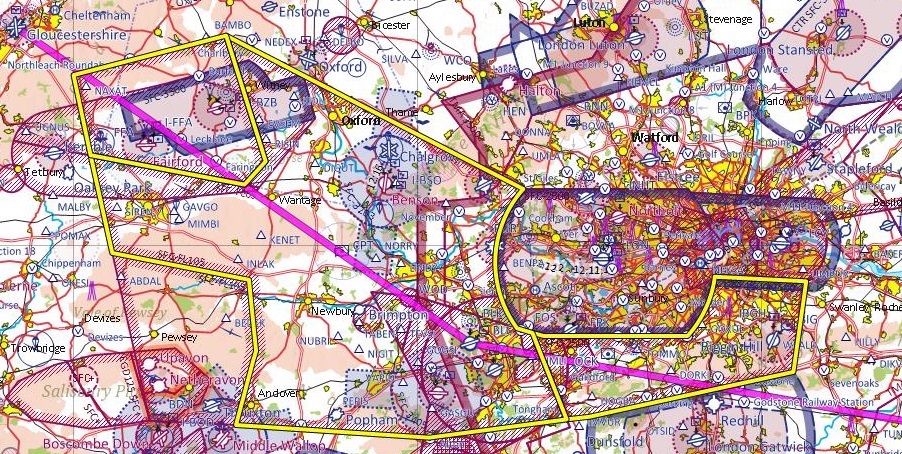
Would it not be relatively trivial to have a programme which drew a polygon and stuck it onto the chart based on coordinates provided in a list form?
I saw something similar in France for a restricted area above a tall ship show.
No idea if it is automated or not.
SD is definitely a bit more extensive in the UK than elsewhere, it is easily explained by their membership :)
I wonder if they do that for every country and every object thus notamed?
There is no obvious automated process.
That’s where SD gets handy :