AF wrote:
The reason that GLONASS satellites don’t really help the accuracy of a fix is that it has its own set of errors, which are different to GPS, and therefore the constellation only adds to the availability of the overall solution, not really the accuracy (except in situations where the observed GPS satellite geometry is poor, and a Glonass bird helps that geometry issue).
GLONASS also increases the total number of satellites in view, thereby reducing the resulting positioning error (which in the first approximation should be, if my intuition serves me well, inversely proportional to the square root of the number of satellites used in the solution).
AF wrote:
The fundamental difference between the satellite systems (GPS, GLO, GALILEO, BEIDOU, etc) and the augmentation systems (WAAS, EGNOS, etc.) is that the augmentation system is transmitting atmospheric corrections which are applied to the signal received from the satellites to minimize/correct signal attenuation errors induced by e.g. the Ionosphere.
Beidou by itself contains an augmentation system of a kind – it has both medium-orbit and geostationary satellites – and the declared accuracy of its military subsystem is as good as 0.1 m.
Ultranomad wrote:
and the declared accuracy of its military subsystem is as good as 0.1 m.
Possibly true.
It isn’t so dissimilar for the military access to the GPS signals too… (they are almost always accurate to sub-meter) because they have access to codes that aren’t released, which improves both the time to fix and accuracy metrics.
You won’t see that in very many places or talked about much outside of academic circles though, because effectively, it doesn’t really matter for civilian use.
An anecdote: the US Military wanted to phase out GPS in support of a new GNSS… but the US public cried foul and the mil had to go back and re-work how to do this without just shutting down the GPS satellites…
Thus the new L5 signal, which is causing them all manner of problems.
This is what doing something nice brings you: obligation and responsibility to those who take up your offer…
(All this GPS navigation stuff wouldn’t really be used if the US military hadn’t switched off Selective Availability in 2000, which scrambled the pseudo-code to disable positions better than about 100m). Now the whole world runs on it…
And they have to carry that service without much payback (although the US economy has definitely reaped the benefits!)
I have just been doing some processing on GPS tracks for subtitling a movie and found that the geoid error in Scotland (Oban) was 200ft whereas just about everywhere else in Europe it is 160ft.
I am referring to the difference between the output of the old SIRF-2 chip, and the real altitude of the airport on which one has landed.
The SIRF-2 was widely used until some years ago but the SIRF-3 replacement has the same issue. And this seems to have carried on because my Samsung phones have the same error. I am not actually sure where it is coming from…
Here is a link to a graphic map of the geoid around the UK and Ireland.
That is very useful NCYankee and it corresponds accurately with my findings. Many thanks.
Copy here in case that link goes dead
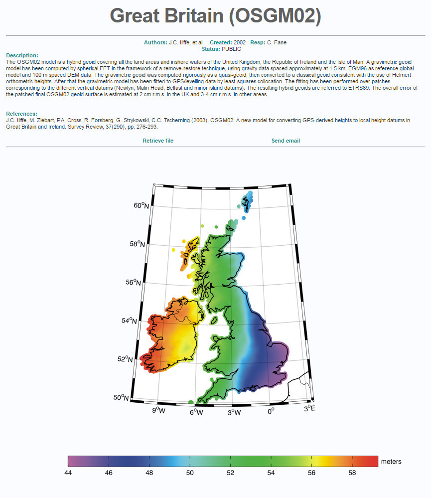
Strangely enough, here’s a copy on a Russian site…
Peter wrote:
I don’t know which direction this is to be applied, however.
It is GPS Value – Geoid Value.
This is the clearest diagram I could find to show it (although the image is fuzzy…)

I am working on a little project with a WAAS/EGNOS GPS module and noticed in the spec that the accuracy is given as 2m without SBAS and 1.5m with SBAS.
This confirms my findings with the Garmin 496 and later with the Garmin Aera 660. SBAS (EGNOS in Europe) makes negligible difference to accuracy, especially the – easily verifiable – vertical accuracy, which is always given within ~10ft by the KLN94 which of course doesn’t do SBAS at all.
Why the poor contribution of SBAS?
And why is it used to deliver so much more in aviation? For example I can’t see why LPV would not work just as well without SBAS. I understand modern navigators can deliver the +V “glideslope” without SBAS. It is probably just the integrity. It is very hard to distort GPS signals in such a way that SBAS would not detect it.
Funny, a colleague of mine have made this altitude app for Samsung smart watches. He is a paraglider. The watch has a barometric altitude meter which works just fine, the only problem is to calibrate it. Punching in the QNH is one solution of course, but this also requires online access which complicates stuff and it’s not available to everyone from anywhere. So he went for using the GPS in the watch and ended up will all these GPS problems concerning alt  He solved it somehow using some corrective maps laying around the internet somewhere I think.