Airplanes still only carry magnetic compasses and no true compasses, so I guess we’re stuck with variation and GPS.
Arne wrote:
Airplanes still only carry magnetic compasses and no true compasses, so I guess we’re stuck with variation and GPS.
An interesting question is if we really need the compasses. Airplanes are always moving so there is always a GPS track. Of course if there is a GPS system failure (or jamming) we have to revert to the old-style navigation.
What we need is an actual compass inside the GPS hardware (or mounted out on a wingtip away from interference), just one of those IC’s like you have in your smartphone, plus a bit of code so that the GPS can automatically look up your variation based on your location, then use that to display magnetic heading, rather than track. Sometimes you need to know where you are pointed rather than where you are going…
What we need is an actual compass inside the GPS hardware (or mounted out on a wingtip away from interference)
That’s how most EFISes are set up.
Magnetic North is magnetic North no matter where it can be pinpointed geographically. At the poles the field is mostly perpendicular to the surface and therefore useless. Away from the poles it is modulated by terrain and rock composition. If it moves around, what does it matter? I mean in a practical sense.
Aren’t there regions where people are flying regularly with deviation of 30 degrees and more ?
EuroFlyer wrote:
Aren’t there regions where people are flying regularly with deviation of 30 degrees and more ?Given the map, Northern Canada obviously.
Yes, don’t panic about the magnetic vs true. Although the magnetic field is changing much faster now than before in a geological timeframe, more dramatic changes will still be many flying careers of time away.
But why not start flying track instead of heading. Track is what gets us where we want. Track is what every tiny GPS chip will tell. Track is what the controllers see on their radar screens. The altitude wind forecast is never accurate anyway, the controllers have to ask for present heading before he issues turns, the old Cherokees suffer from frequent vacuum failures and hence no steady heading indication, we all have track information backup in the pocket while only geriatric scouts have backup heading information there, autopilot coupling to track is simpler and cheaper that to heading etc…
True track or magnetic, whatever, but I think heading just seems increasingly as a complication to navigation.
Coda wrote:
plus a bit of code so that the GPS can automatically look up your variation based on your location
That’s how the IRU on the likes of the 777 determines local magnetic declination. Garmin’s integrated flight decks do the same. The magnetic compass, whether it’s a whiskey variety or a wing-mounted 3-axis magnetometer with a RS-485 link, is also present as a backup but they’re notoriously error-prone and the latter will only be accurate to within 2 degrees of the local magnetic direction if it’s something like a Bendix King KCS 55A system.
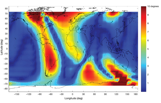
A weakness in the use of MagVar tables is the use of an outdated epoch. The secular variation accumulated over the life of an epoch can produce an error, in some regions, whose magnitude exceeds what the underlying instruments are capable of producing. As an extreme example consider the change in declination between the 1980 and 2005 epochs as illustrated in a Boeing AERO Magazine (Q4, 2009) article, Correcting the Effects of Magnetic Variation :
AIUI every certified IFR GPS includes a means of calculating the mag variation from the GPS position, and this is how it can fly a “magnetic” track etc.
If, or how often, this gets updated, I have no idea…
In most (all?) units this is implemented as a 2D lookup table which is interpolated. An alternative means is a polynomial (you can find it on google) but that works only between certain latitudes, and I am sure it is quite impossible to construct a polynomial with a finite number of terms which would work at the poles 
huv wrote:
But why not start flying track instead of heading. Track is what gets us where we want. Track is what every tiny GPS chip will tell. Track is what the controllers see on their radar screens.
Flying a constant track value will result in a loxodrome (rhumb line) which is typically inefficient over large distances. A track angle is nothing more than the direction of a tangent to the path measured at the position of the aircraft.