One needs a PhD to work out the pricing but this is what the price list shows
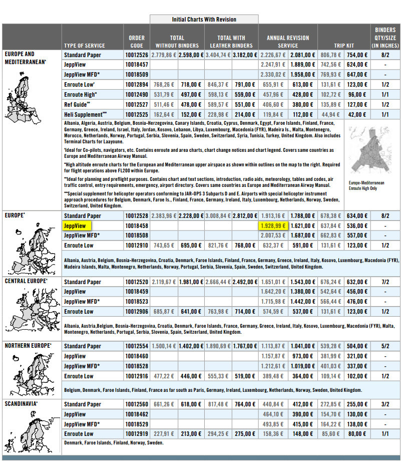
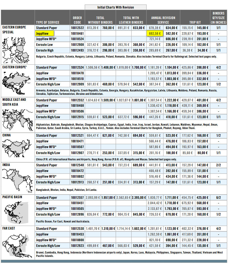
so to get what Joe Public (well anybody who attended a school) would call “Europe”, and more to the point to get coverage for not just “nice” places like the Czech Rep but also coverage for the area which one can fly around without permits etc, you need to spend 1928+692=€2620, including VAT.
Europe VFR is €329 on top:
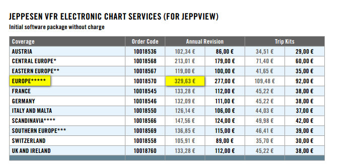
which is not as bad as it looks if you can chuck away subs to other VFR products, especially the German VFR plates. Against that you have the MFD-VFR product at €297 for n+1 year, and I believe this includes the plates in the above “Europe VFR” – Peter Mundy sells these so will no doubt confirm or not.

Bear in mind that even if you have an IR, the moment you
you need a good VFR chart, not some synthetic presentation with no spot elevations. Of the current tablet products, Jepp MFD-VFR is the best.
That gives you four installations, and you are right, I can’t find a single device Jeppview sub.
But they play the same “Europe” trick for the Ipad platforms but possibly with slightly different map collections (I can’t find the actual maps). This is for a single device i.e. no backup in the cockpit unless you laboriously print off the individual pages:

Historically most pilots with money have gone for Jeppview and maybe one panel mounted platform, which seems to be in the region of €2600/year. That gives them 3 or 4 PC installations, so they can get 2 or 3 other people to contribute to the cost (not quite in line with Jepp T+Cs IIRC but they have told enough customers that they don’t really care). Most of these people bought all of Europe plus the VFR Europe which seems to be around 3k now – a big increase from the ~2k I recall from some years ago.
These Jepp pricing debates always come back to what exact coverage you are getting. And the net cost to you the customer depends on what you can share with friends. The Ipad subs and the panel mount subs cannot be shared – short of (obviously) syndicating the Ipad and/or the aircraft.
I would never ever fly with the plates on just one device. I have had many shutdowns and they happen right when you need the stuff. The only device which I always have to hand and which has never shut down is my Samsung phone but that cannot run any of these apps. All one can have on a phone is PDFs, which takes us back to Jeppview 
If you can jailbreak two Ipads then it should be possible to clone the single-device installation. But you need to know how to hack the unix file system in there. I did a bit of that years ago to fix some trivia and even that was messy.
Well… i dont dispatch in low IFR, not at night IMC and not in icy weather so I am kind of a good weather IFR pilot. Plus: I will print the most critical plates. So Imconsider that a lot should go very wrong bfore ending up without options … unless someone brings me scnearios that i did not consider…
@peter : I converted to that IFR single install VFR+IFR. Czech Republic only gives the VFR charts.
One solution with only one key. Generate .PDFs with Jeppview on your laptop which you bring with you in the cockpit before departure. Distribute the PDFs to your iPads (via mail/Bluetooth etc), use them with a suitable reader such as Goodreader.
Even better if there is a full version of Windows 10 on a small tablet (?) running Jeppview. Anyone tried?
@Jonas : i dont think you can purchase a single install Windows license of Jeppview, unless you consider it part of a 4 key subscription, or am I wrong?
One solution with only one key. Generate .PDFs with Jeppview on your laptop which you bring with you in the cockpit before departure. Distribute the PDFs to your iPads (via mail/Bluetooth etc), use them with a suitable reader such as Goodreader.
Yes, obviously Though I am not sure you can auto-sync files over bluetooth.
Some people use dropbox to replicate the PDFs across devices, but that needs every device internet-connected which will bite you in the bum one day, at some airport when you have no wifi and your SIMs don’t all roam, or the prepaid ones have run out….
With Jeppview on a PC, it is really quick to print off the PDF for every airport anywhere near your proposed trip. And if you carry a laptop or a tablet with a keyboard+mouse then you can have Jeppview on that, which takes care of any unexpected plan changes.
Even better if there is a full version of Windows 10 on a small tablet (?) running Jeppview. Anyone tried?
Yes, though with win8, not win10. However the Jepp PC software is barely usable on a tablet. Like with most serious jobs, you need a proper PC with a keyboard and a mouse/trackball.
Windows tablets are all basically crap in raw usability, compared to android ones, or an Ipad – because Windows is a torture with a touch screen. However many people use them for good reasons e.g. running serious apps they need. I fly with a win8 tablet because I need the Thuraya satphone connection. The MS Surface tablets are nice, with the keyboard and a mouse, but IMHO all too large for in-cockpit use as a moving map.
i dont think you can purchase a single install Windows license of Jeppview, unless you consider it part of a 4 key subscription, or am I wrong?
You appear to be correct (which was news to me – see above). But four people can buy Jeppview and split the cost 4 ways. Still pricey but 1/4 of 2.6k is a lot better than 2.6k… 400% better, as the Daily Trash would write it.
Seems like a bit of a strong statement given the amount of people who successfully use Skydemon (and soon garmin pilot, and I don’t kno embuchada about foreflight so can’t comment)
I had a look a while ago at Jeep VFR product (not sure which one) and wasn’t impressed.
you need a good VFR chart, not some synthetic presentation with no spot elevations. Of the current tablet products, Jepp MFD-VFR is the best.
I think it depends on what you want to use it for. CAS avoidance, no problem. For an engine failure above an overcast above some terrain, this thread is worth a read.
There is a long thread on the Jepp VFR product here and for sure other products are much more feature-packed, but that’s a different question. There doesn’t appear to be a European VFR product which does the job well for all the points I mentioned in post #12. The Jepp database is probably the best but their app is nowhere near as functional as the others.
I’d argue that a good VFR chart doesn’t need a ton of elevations, since you should be able to see the terrain (well, maybe not entirely true at night or in 1500m visibility). In mountains you need to have an idea where you can pass, but precision is not really needed (that wouuld mean you keep no margin)
In my view, you are describing “avoidance of terrain when not being able to see outside” which is more of a complement to an IFR product than a needed piece of a VFR tool.
All the VFR flight I’ve done in the mountains was either with SkyDemon (for rough navigation), or with no map at all. In the latter case terrain clearance is sometimes very small (maybe something like 200ft), but you generally can see in advance if you are going to pass or not (geometry rule, if you see the feature behind getting more visible / “bigger”, then you’ll pass).
But obviously if flying in the UK, VFR, which is SD’s primary market, there are no real onstacles. The biggest stuff is about 3000ft and you have to go to Wales to find it. I used to fly Shoreham – Welshpool (N Wales) at ~1500ft.
you are describing “avoidance of terrain when not being able to see outside” which is more of a complement to an IFR product than a needed piece of a VFR tool.
Not if the plane is all working ok (you will be either at the enroute MEA or flying a SID/STAR/IAP) hence my comment about emergencies.
But very few pilots will choose a VFR nav product for terrain presentation, like I would, finding myself in sticky situations occassionally. OTOH the OP is obviously an IR holder.