
I guess this is a UK phenomena, being anti-GPS. I have never met anyone being anti-GPS. Every school, every club here have courses and even flight training for VFR-GPS. It’s a tool like ADF or VOR and can be used when flying VFR.
But, in my opinion it should remain a extra tool. I just cannot see any positive effect of making GPS navigation compulsory for VFR. The only effect it will have is raising the bar for the equipment needed for flying VFR. Why would anyone chose to do that?
I don’t agree that a GNS430 or some other panel mount is bad for VFR
Well, sure, it can be used, if you’re immune to pain. But it’s a very inefficient way to use one’s funds, anything you can do with a panel mount for VFR you can do a lot better with your tablet/phone and an application, at a small fraction of the cost
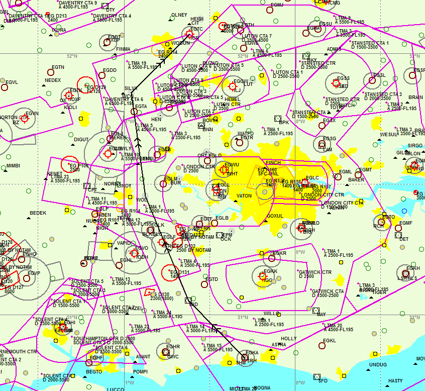
This is a route from Shoreham EGKA to Cranfield EGTC via MID WOD WCO and it is very close to the optimum you would fly using any other tool.
Sure, you can find the occasional city pair where it works like this. And if you’re happy to choose the airports to visit by the availability of a good route using VOR’s, go for it. I tend to want to choose the places to visit using different criteria. In my part of the world, I would get nowhere using that strategy.
The exception to the foregoing would be if flying VFR through airspace which is so complicated that it is almost impossible to plan an OCAS route using existing database waypoints
So that means 100 NM around all major european capitals are off limits
tablet solely you don’t get great stuff like the projected fuel on board at destination…
Yeah right. How many basic training aircraft will have an installation that is capable of this? The original topic was whether it makes sense to install a panel mount GPS in a basic trainer used for PPL training – such as a C152.
I’m still very much convinced it makes no sense, because:
Aircraft with a panel mounted IFR approach approved GPS is still in the minority in the US with 33.3% so equipped. However VFR GPS equipage is fairly high at 41.3%. Overall, GPS panel mount equipage is pretty ubiquitous in addition to very high use of portables. There are still a fairly large number of IFR flights that use the domestic equipment codes of /U (transponder) or /A (transponder with DME) which don’t claim any GPS capability.
In September 2013 I flew with my family on a Cirrus SR20 VFR from Germany through the Czech Republic, Slovakia, Hungary, into Romania and back to Germany through Austria. VFR in Eastern Europe feels like IFR because of ATC – just stay away from the clouds.
To prepare each flight I used Skydemon and then entered the flight plan into the GNS430 and had it visualized on the MFD. Because of the GNS430 I only used IFR waypoints. A good part of the flights was in VMC on top of clouds. SD was running as a 3rd screen and logging so I always had perfect awareness of my position and what might come next.
The flight school in EDFE (Egelsbach) where I reactivated my PPL after a 17 year long pause a few months earlier before going on that long trip makes a point to have the most current equipment. All their aircraft are EFIS or “glass”. They charge the same money for training or renting their aircraft as anybody else. One of the examiners working in that district is one of their instructors as well and the head instructor flies business jets for Netjets.
Sometime in 1989 when I did my PPL the first time I learned visual navigation with map and clock. Radio navigation was never a topic and I learned about VORs on my own. It proved to be helpful during my first landing at Brussels with a PA-28 Warrior. Later I convinced the owner to install a Garmin GPS100 and one of the instructors of a flight school at EDVK just last year reached out to me to comment on my remarks years about that having a moving map would be so helpful. Back then when I was advocating the GPS100 he deemed it unnecessary. Yes, it was. I flew from EDVK to Budapest in another PA-28 from VOR to VOR as VFR-only PPL and that worked but all the cross-checking was tedious.
I believe that once people start to go places the use of GPS is a no-brainer. If they only fly around the local airfield, then they never realize the value and are overwhelmed with all the things one is supposed to know. The same talk happened when I learned on my own about VOR navigation and how to use the localizer for my flight to Brussels. It is related to small aircraft “as a means for travel” vs “as a hobby”.
In the UK, I’ll bet the anti-GPS crowd are mostly the folks who fly no more than 25 nm from their home airfield.
A certified onboard GPS is far more reliable (and even redundant in most IFR aircraft).
Exactly. If GPS is to be used as more than a “ad hoc, but unnecessary” addition, then it needs to be certified and panel mount. That wouldn’t be a bad thing, but it would make aircraft even more complex and expensive.
VFR navigation is not complicated. You don’t need a GPS to do it. It’s like saying you need a PC and excel to add together a couple of numbers.
Funny thing. VFR navigation (precision navigation) is a sport practice’s by many PPL pilots. To judge the accuracy, a GPS logger is mandatory in competitions 
If you are tired of looking out the window, then EIR is the next step.
yes but why would one want to use the FPL function for VFR, given it’s a major PITA to use
My point was that VFR pilots are not trained to do anything with the GPS, except maybe using the DCT button.
A function which is very useful for VFR is the OBS function. I always use it when flying to a unknown VFR field. Its a great tool to visualize where the circuit is.
Having a FPL loaded will give you any data which is on the PLOG, but far more accurate. ETE, ETA, tracks, distances, fuel calculations, etc.
When I am flying VFR, I just use IFR waypoints. I can imagine that for a flight through valleys that won’t work and you have to use user waypoints.
But for a simple flight like EHLE-EGKA it will work just fine.
I have a tablet running Skydemon, and use that as well. But the GPS signal is not reliable. It might not get a fix at all when it is switched on during flight.
A certified onboard GPS is far more reliable (and even redundant in most IFR aircraft).
There is a UK PPL instructor I know who says that you could teach the entire PPL using GPS navigation (I mean actually flying with GPS) except ~2 specific exercises which require DR.
That would be a novel approach and I wonder if any other country in Europe does it.
As to what happens in the PPL skills test is another matter. I know that in the FAA system the examiner can request the demonstration of all installed equipment, but I don’t think that’s the case in Europe. And the school has to teach to pass the skills test.
I know that in the IR skills test the examiner could ask for an installed GPS to be used but one IR examiner told me that FTOs get around that by making the database 1 or 2 cycles out of date, which totally prevents it being used for any test.
BTW I don’t agree that a GNS430 or some other panel mount is bad for VFR. I have been flying VFR with my KLN94 since 2002. All I do is plan a route around waypoints which are already in the database. In most cases there are enough waypoints for the job, especially if airway intersections are used. This is a route from Shoreham EGKA to Cranfield EGTC via MID WOD WCO and it is very close to the optimum you would fly using any other tool. I run a GPS moving map on a tablet, showing the “real printed” chart and then I can use that for shortcuts or just for any change of plan, but the primary plan is on the KLN94 whose battery will never go flat and which will never shut down because it has sunlight shining on it… Obviously it’s a lot quicker to enter a route into any of the tablet apps and fly with that, but then if the tablet packs up or crashes (which happens a lot) you have nothing. The exception to the foregoing would be if flying VFR through airspace which is so complicated that it is almost impossible to plan an OCAS route using existing database waypoints, as for example in the recent VFR flight I did from Bergerac to Cannes to Lucca. I would never use user-specified waypoints; too much hassle. But then if you use the tablet solely you don’t get great stuff like the projected fuel on board at destination…
Page 185:
(xxiv) Exercise 18c: Radio navigation:
(A) use of GNSS:
(a) selection of waypoints;
(b) to or from indications and orientation;
(c) error messages.
It’s in the LAPL-Syllabus, too.
And the syllabus has to be filled with life by an instructor. This is as true for GNSS navigation, as it is for slow flight or crosswind take offs.
GPS IS part of the EASA PPL-syllabus. (AMC1 FCL.210; FCL.215)
This is the Syllabus of Theoretical Knowledge
It is very far away from teaching anything useful on how to use a GPS.


